Lake Worth Topo Map Texas
To zoom in, hover over the map of Lake Worth
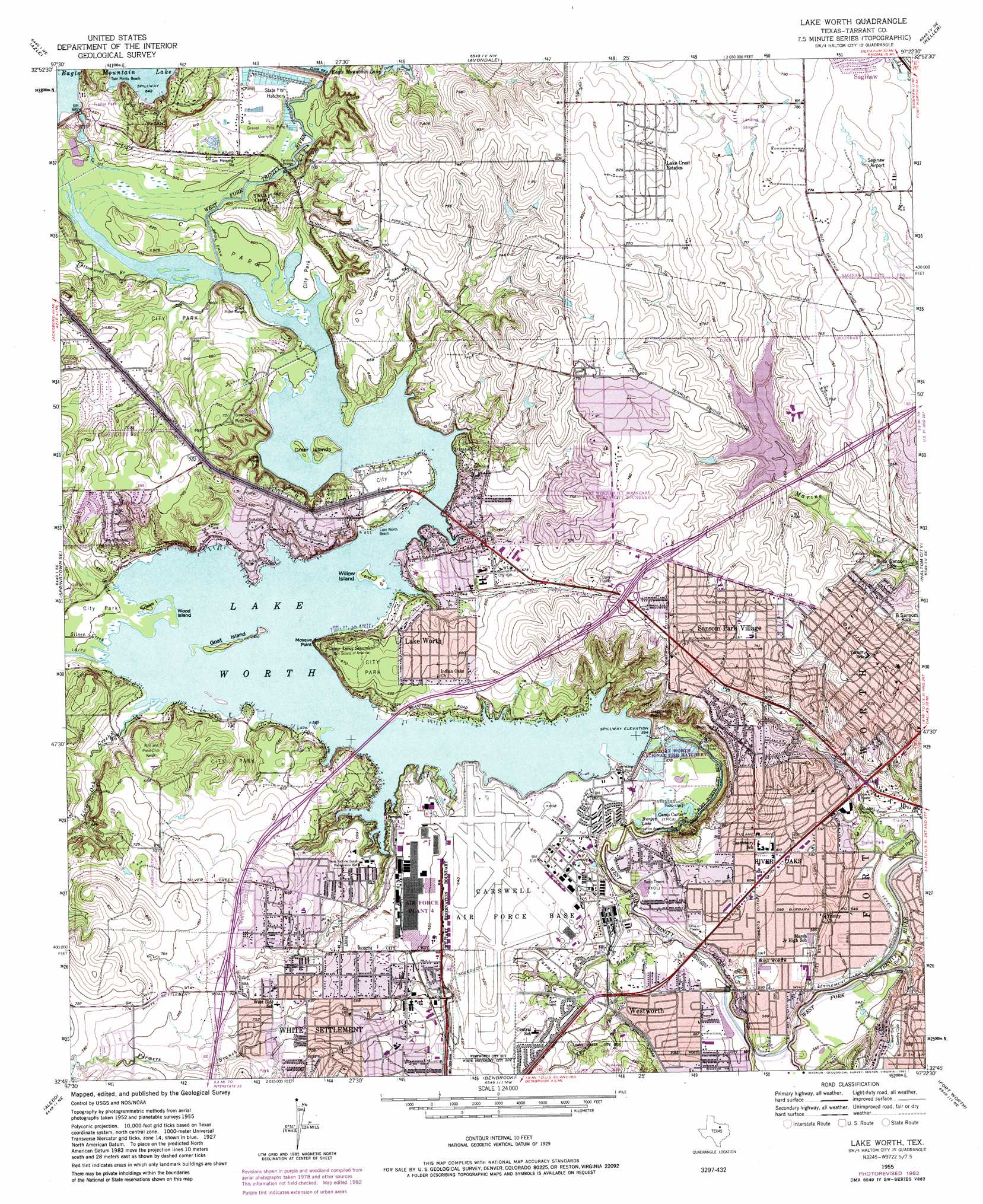
USGS Topo Quad 32097g4 - 1:24,000 scale
| Topo Map Name: | Lake Worth |
| USGS Topo Quad ID: | 32097g4 |
| Print Size: | ca. 21 1/4" wide x 27" high |
| Southeast Coordinates: | 32.75° N latitude / 97.375° W longitude |
| Map Center Coordinates: | 32.8125° N latitude / 97.4375° W longitude |
| U.S. State: | TX |
| Filename: | o32097g4.jpg |
| Download Map JPG Image: | Lake Worth topo map 1:24,000 scale |
| Map Type: | Topographic |
| Topo Series: | 7.5´ |
| Map Scale: | 1:24,000 |
| Source of Map Images: | United States Geological Survey (USGS) |
| Alternate Map Versions: |
Lake Worth TX 1955, updated 1957 Download PDF Buy paper map Lake Worth TX 1955, updated 1969 Download PDF Buy paper map Lake Worth TX 1955, updated 1974 Download PDF Buy paper map Lake Worth TX 1955, updated 1982 Download PDF Buy paper map Lake Worth TX 1955, updated 1982 Download PDF Buy paper map Lake Worth TX 1995, updated 2001 Download PDF Buy paper map Lake Worth TX 2010 Download PDF Buy paper map Lake Worth TX 2013 Download PDF Buy paper map Lake Worth TX 2016 Download PDF Buy paper map |
1:24,000 Topo Quads surrounding Lake Worth
Cottondale |
Boyd |
Rhome |
Justin |
Argyle |
Springtown |
Azle |
Avondale |
Keller |
Colleyville |
Lake Weatherford |
Springtown Se |
Lake Worth |
Haltom City |
Hurst |
Anneta |
Aledo |
Benbrook |
Fort Worth |
Kennedale |
Chapin |
Cresson |
Primrose |
Burleson |
Mansfield |
> Back to 32097e1 at 1:100,000 scale
> Back to 32096a1 at 1:250,000 scale
> Back to U.S. Topo Maps home
Lake Worth topo map: Gazetteer
Lake Worth: Airports
Cowden Heliport elevation 239m 784′Saginaw Airport elevation 232m 761′
Stubbs Strip elevation 222m 728′
Lake Worth: Beaches
Lake Worth Beach elevation 181m 593′Twin Points Beach elevation 210m 688′
Lake Worth: Bridges
Tenmile Bridge elevation 186m 610′Lake Worth: Capes
Mosque Point elevation 200m 656′Lake Worth: Cliffs
Inspiration Point elevation 220m 721′Lone Point elevation 193m 633′
Lake Worth: Dams
Eagle Mountain Dam elevation 196m 643′Lake Worth Dam elevation 180m 590′
Marine Creek Dam elevation 195m 639′
Lake Worth: Islands
Goat Island elevation 186m 610′Greer Island elevation 187m 613′
Snake Island elevation 183m 600′
Willow Island elevation 183m 600′
Wood Island elevation 183m 600′
Lake Worth: Lakes
Burger Lake elevation 169m 554′Lake Worth: Parks
Broadview Picnic Area elevation 213m 698′Casino Park elevation 184m 603′
Fort Worth Refuge elevation 208m 682′
Kelly Park elevation 161m 528′
Kittrell Stadium elevation 232m 761′
Marine Creek Lake Park elevation 215m 705′
W O Barnes Stadium elevation 181m 593′
White Settlement City Park elevation 219m 718′
Willow Creek Park elevation 219m 718′
Lake Worth: Populated Places
Lake Crest Estates elevation 248m 813′Lake Worth elevation 196m 643′
Lakeside elevation 217m 711′
River Oaks elevation 183m 600′
Sansom Park elevation 229m 751′
Westworth elevation 173m 567′
White Settlement elevation 203m 666′
Lake Worth: Reservoirs
Lake Worth elevation 173m 567′Marine Creek Reservoir elevation 195m 639′
Lake Worth: Streams
Cottonwood Branch elevation 183m 600′Farmers Branch elevation 162m 531′
Kings Branch elevation 172m 564′
Live Oak Creek elevation 181m 593′
Silver Creek elevation 184m 603′
Lake Worth: Trails
Crosstimbers Trail elevation 189m 620′Fort Worth Nature Center and Refuge Trails elevation 204m 669′
Lake Worth digital topo map on disk
Buy this Lake Worth topo map showing relief, roads, GPS coordinates and other geographical features, as a high-resolution digital map file on DVD: