Poolville Topo Map Texas
To zoom in, hover over the map of Poolville
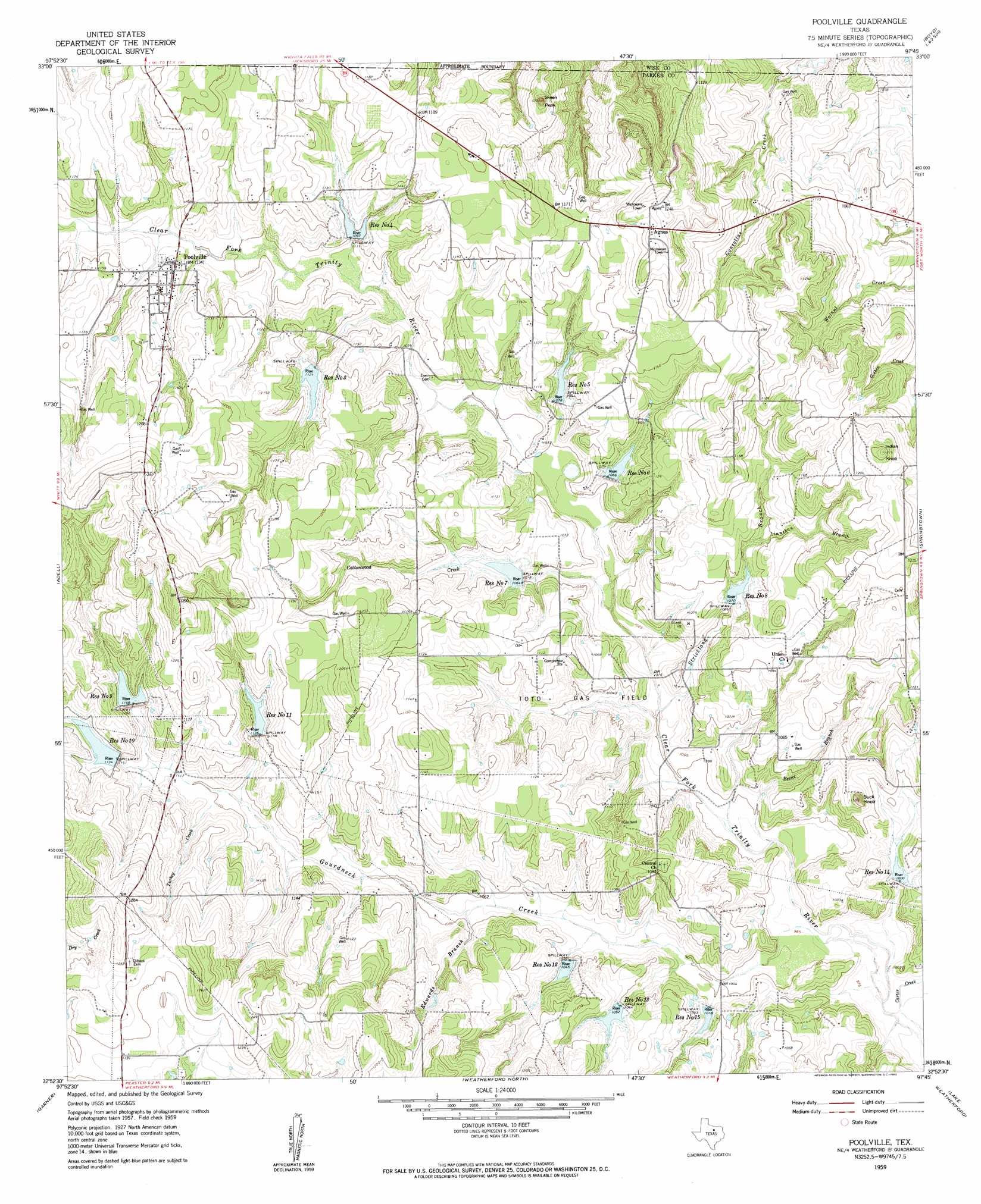
USGS Topo Quad 32097h7 - 1:24,000 scale
| Topo Map Name: | Poolville |
| USGS Topo Quad ID: | 32097h7 |
| Print Size: | ca. 21 1/4" wide x 27" high |
| Southeast Coordinates: | 32.875° N latitude / 97.75° W longitude |
| Map Center Coordinates: | 32.9375° N latitude / 97.8125° W longitude |
| U.S. State: | TX |
| Filename: | o32097h7.jpg |
| Download Map JPG Image: | Poolville topo map 1:24,000 scale |
| Map Type: | Topographic |
| Topo Series: | 7.5´ |
| Map Scale: | 1:24,000 |
| Source of Map Images: | United States Geological Survey (USGS) |
| Alternate Map Versions: |
Poolville TX 1959, updated 1960 Download PDF Buy paper map Poolville TX 1959, updated 1960 Download PDF Buy paper map Poolville TX 2010 Download PDF Buy paper map Poolville TX 2012 Download PDF Buy paper map Poolville TX 2016 Download PDF Buy paper map |
1:24,000 Topo Quads surrounding Poolville
Jacksboro Ne |
Wizard Wells |
Bridgeport West |
Bridgeport East |
Decatur |
Perrin |
Gibtown |
Boonsville |
Cottondale |
Boyd |
Whitt |
Adell |
Poolville |
Springtown |
Azle |
Mineral Wells East |
Garner |
Weatherford North |
Lake Weatherford |
Springtown Se |
Brazos East |
Brock |
Weatherford South |
Anneta |
Aledo |
> Back to 32097e1 at 1:100,000 scale
> Back to 32096a1 at 1:250,000 scale
> Back to U.S. Topo Maps home
Poolville topo map: Gazetteer
Poolville: Dams
Soil Conservation Service Site 10 Dam elevation 350m 1148′Soil Conservation Service Site 11 Dam elevation 353m 1158′
Soil Conservation Service Site 12 Dam elevation 314m 1030′
Soil Conservation Service Site 13 Dam elevation 321m 1053′
Soil Conservation Service Site 14 Dam elevation 309m 1013′
Soil Conservation Service Site 15 Dam elevation 312m 1023′
Soil Conservation Service Site 3 Dam elevation 343m 1125′
Soil Conservation Service Site 4 Dam elevation 352m 1154′
Soil Conservation Service Site 5 Dam elevation 331m 1085′
Soil Conservation Service Site 6 Dam elevation 329m 1079′
Soil Conservation Service Site 7 Dam elevation 327m 1072′
Soil Conservation Service Site 8 Dam elevation 327m 1072′
Soil Conservation Service Site 9 Dam elevation 349m 1145′
Poolville: Oilfields
Toto Gas Field elevation 322m 1056′Poolville: Populated Places
Agnes elevation 370m 1213′Poolville elevation 345m 1131′
Poolville: Reservoirs
Reservoir Number Eight elevation 331m 1085′Reservoir Number Eleven elevation 351m 1151′
Reservoir Number Fifteen elevation 316m 1036′
Reservoir Number Five elevation 326m 1069′
Reservoir Number Four elevation 332m 1089′
Reservoir Number Fourteen elevation 307m 1007′
Reservoir Number Nine elevation 350m 1148′
Reservoir Number Seven elevation 328m 1076′
Reservoir Number Six elevation 332m 1089′
Reservoir Number Ten elevation 349m 1145′
Reservoir Number Thirteen elevation 324m 1062′
Reservoir Number Three elevation 343m 1125′
Reservoir Number Twelve elevation 319m 1046′
Soil Conservation Service Site 10 Reservoir elevation 350m 1148′
Soil Conservation Service Site 11 Reservoir elevation 353m 1158′
Soil Conservation Service Site 12 Reservoir elevation 314m 1030′
Soil Conservation Service Site 13 Reservoir elevation 321m 1053′
Soil Conservation Service Site 14 Reservoir elevation 309m 1013′
Soil Conservation Service Site 15 Reservoir elevation 312m 1023′
Soil Conservation Service Site 3 Reservoir elevation 343m 1125′
Soil Conservation Service Site 4 Reservoir elevation 352m 1154′
Soil Conservation Service Site 5 Reservoir elevation 331m 1085′
Soil Conservation Service Site 6 Reservoir elevation 329m 1079′
Soil Conservation Service Site 7 Reservoir elevation 327m 1072′
Soil Conservation Service Site 8 Reservoir elevation 327m 1072′
Soil Conservation Service Site 9 Reservoir elevation 349m 1145′
Poolville: Streams
Beene Branch elevation 301m 987′Cottonwood Creek elevation 309m 1013′
Edwards Branch elevation 316m 1036′
Gourdneck Creek elevation 296m 971′
Linnehan Branch elevation 330m 1082′
Strickland Branch elevation 305m 1000′
Turkey Creek elevation 332m 1089′
Poolville: Summits
Buck Knob elevation 345m 1131′Indian Knob elevation 387m 1269′
Skeen Peak elevation 373m 1223′
Poolville digital topo map on disk
Buy this Poolville topo map showing relief, roads, GPS coordinates and other geographical features, as a high-resolution digital map file on DVD: