Dublin Topo Map Texas
To zoom in, hover over the map of Dublin
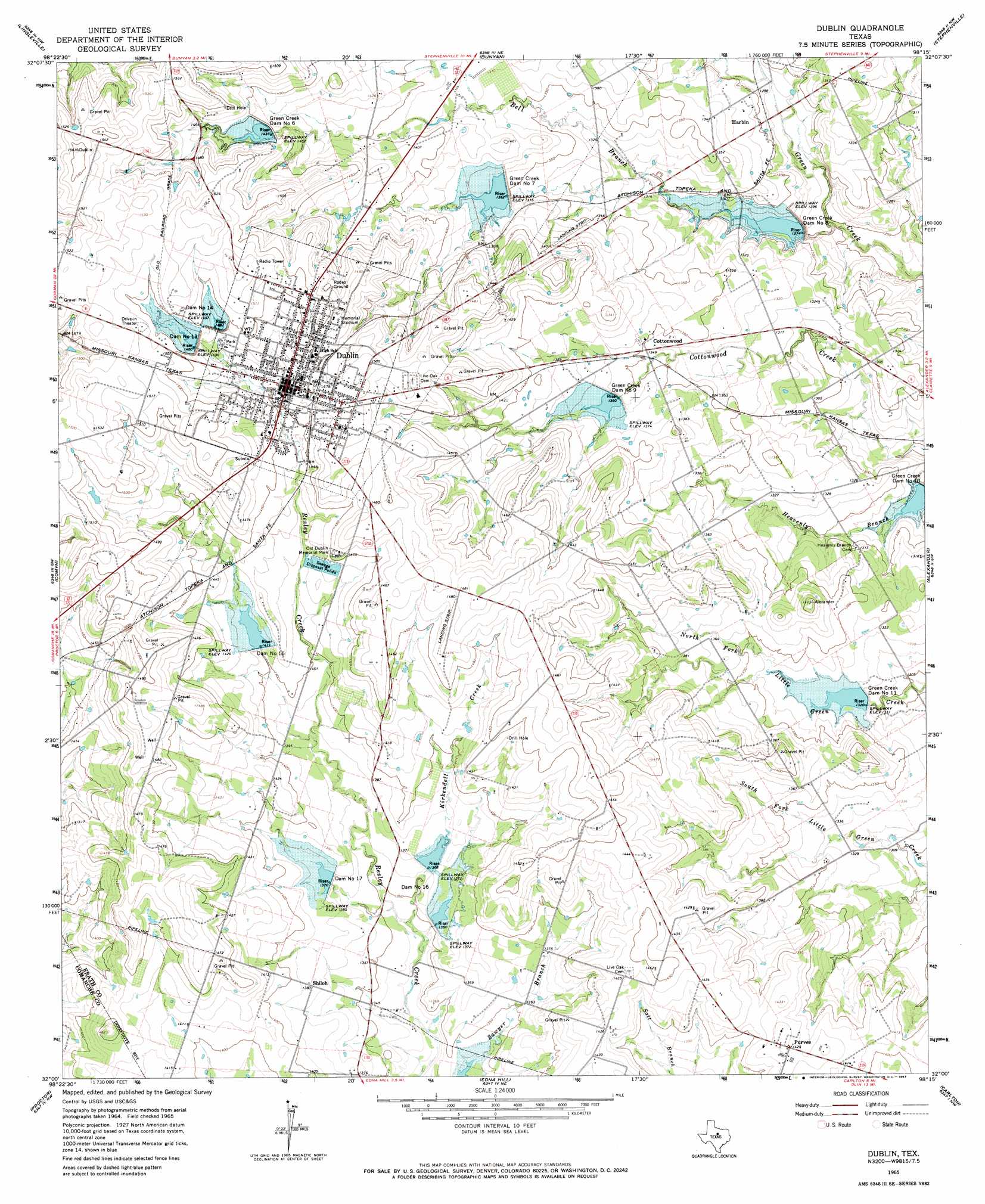
USGS Topo Quad 32098a3 - 1:24,000 scale
| Topo Map Name: | Dublin |
| USGS Topo Quad ID: | 32098a3 |
| Print Size: | ca. 21 1/4" wide x 27" high |
| Southeast Coordinates: | 32° N latitude / 98.25° W longitude |
| Map Center Coordinates: | 32.0625° N latitude / 98.3125° W longitude |
| U.S. State: | TX |
| Filename: | o32098a3.jpg |
| Download Map JPG Image: | Dublin topo map 1:24,000 scale |
| Map Type: | Topographic |
| Topo Series: | 7.5´ |
| Map Scale: | 1:24,000 |
| Source of Map Images: | United States Geological Survey (USGS) |
| Alternate Map Versions: |
Dublin TX 1965, updated 1967 Download PDF Buy paper map Dublin TX 2010 Download PDF Buy paper map Dublin TX 2012 Download PDF Buy paper map Dublin TX 2016 Download PDF Buy paper map |
1:24,000 Topo Quads surrounding Dublin
Desdemona |
Huckabay Sw |
Huckabay |
Knob Hill |
Bluff Dale |
Rucker |
Lingleville |
Bunyan |
Stephenville |
Johnsville |
De Leon |
Comyn |
Dublin |
Alexander |
Clairette |
Comanche |
Proctor |
Edna Hill |
Carlton |
Hico |
Newburg |
Gustine |
Lamkin |
Gentrys Mill |
Eidson Lake |
> Back to 32098a1 at 1:100,000 scale
> Back to 32098a1 at 1:250,000 scale
> Back to U.S. Topo Maps home
Dublin topo map: Gazetteer
Dublin: Airports
Dublin Municipal Airport elevation 451m 1479′Dublin: Dams
Dam Number 13 elevation 451m 1479′Dam Number 14 elevation 456m 1496′
Dam Number 15 elevation 431m 1414′
Dam Number 16 elevation 417m 1368′
Dam Number 17 elevation 418m 1371′
Green Creek Dam Number 10 elevation 387m 1269′
Green Creek Dam Number 11 elevation 404m 1325′
Green Creek Dam Number 6 elevation 443m 1453′
Green Creek Dam Number 7 elevation 411m 1348′
Green Creek Dam Number 8 elevation 394m 1292′
Green Creek Dam Number 9 elevation 418m 1371′
Hopson Dam elevation 423m 1387′
Soil Conservation Service Site 10 Dam elevation 387m 1269′
Soil Conservation Service Site 11 Dam elevation 403m 1322′
Soil Conservation Service Site 13 Dam elevation 454m 1489′
Soil Conservation Service Site 14 Dam elevation 452m 1482′
Soil Conservation Service Site 15 Dam elevation 430m 1410′
Soil Conservation Service Site 16-1 Dam elevation 409m 1341′
Soil Conservation Service Site 16-2 Dam elevation 414m 1358′
Soil Conservation Service Site 17 Dam elevation 418m 1371′
Soil Conservation Service Site 6 Dam elevation 437m 1433′
Soil Conservation Service Site 7 Dam elevation 417m 1368′
Soil Conservation Service Site 8 Dam elevation 385m 1263′
Soil Conservation Service Site 9 Dam elevation 414m 1358′
Dublin: Parks
Memorial Stadium elevation 455m 1492′Dublin: Populated Places
Cottonwood elevation 410m 1345′Dublin elevation 446m 1463′
Harbin elevation 396m 1299′
Purves elevation 435m 1427′
Shiloh elevation 421m 1381′
Dublin: Reservoirs
Hopson Lake elevation 423m 1387′Soil Conservation Service Site 10 Reservoir elevation 387m 1269′
Soil Conservation Service Site 11 Reservoir elevation 403m 1322′
Soil Conservation Service Site 13 Reservoir elevation 454m 1489′
Soil Conservation Service Site 14 Reservoir elevation 452m 1482′
Soil Conservation Service Site 15 Reservoir elevation 430m 1410′
Soil Conservation Service Site 16-1 Reservoir elevation 409m 1341′
Soil Conservation Service Site 16-2 Reservoir elevation 414m 1358′
Soil Conservation Service Site 17 Reservoir elevation 418m 1371′
Soil Conservation Service Site 6 Reservoir elevation 437m 1433′
Soil Conservation Service Site 7 Reservoir elevation 417m 1368′
Soil Conservation Service Site 8 Reservoir elevation 385m 1263′
Soil Conservation Service Site 9 Reservoir elevation 414m 1358′
Dublin: Streams
Bell Branch elevation 379m 1243′Kirkendell Creek elevation 408m 1338′
Dublin digital topo map on disk
Buy this Dublin topo map showing relief, roads, GPS coordinates and other geographical features, as a high-resolution digital map file on DVD: