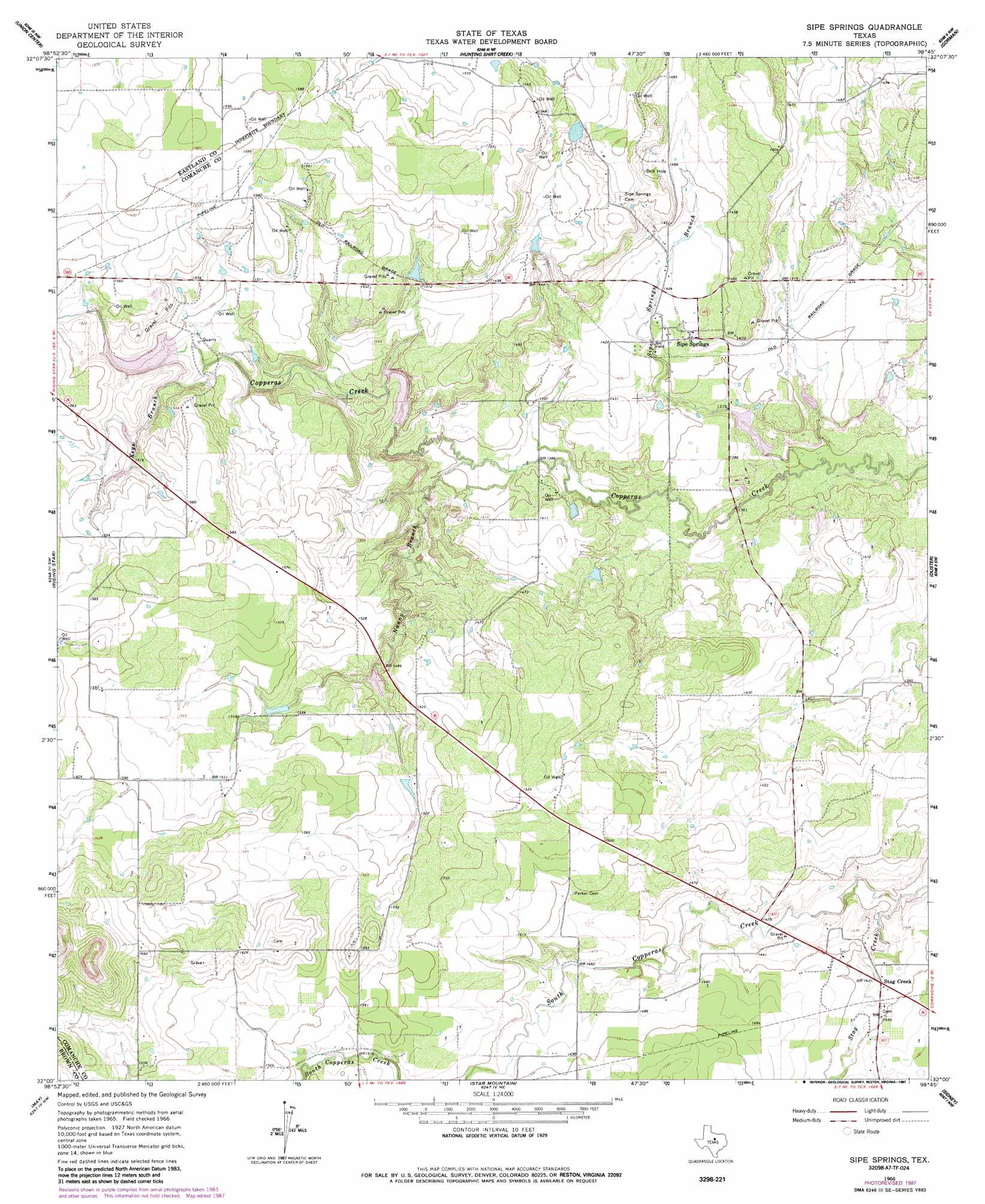
Sipe Springs Topo Map Texas
To zoom in, hover over the map of Sipe Springs
USGS Topo Quad 32098a7 - 1:24,000 scale
| Topo Map Name: | Sipe Springs |
| USGS Topo Quad ID: | 32098a7 |
| Print Size: | ca. 21 1/4" wide x 27" high |
| Southeast Coordinates: | 32° N latitude / 98.75° W longitude |
| Map Center Coordinates: | 32.0625° N latitude / 98.8125° W longitude |
| U.S. State: | TX |
| Filename: | o32098a7.jpg |
| Download Map JPG Image: | Sipe Springs topo map 1:24,000 scale |
| Map Type: | Topographic |
| Topo Series: | 7.5´ |
| Map Scale: | 1:24,000 |
| Source of Map Images: | United States Geological Survey (USGS) |
| Alternate Map Versions: |
Sipe Springs TX 1966, updated 1968 Download PDF Buy paper map Sipe Springs TX 1966, updated 1987 Download PDF Buy paper map Sipe Springs TX 2010 Download PDF Buy paper map Sipe Springs TX 2012 Download PDF Buy paper map Sipe Springs TX 2016 Download PDF Buy paper map |
1:24,000 Topo Quads surrounding Sipe Springs
Scranton |
Cisco South |
Carbon |
Kokomo |
Desdemona |
Sabanno |
Union Center |
Hunting Shirt Creek |
Gorman |
Rucker |
Pioneer |
Rising Star |
Sipe Springs |
Duster |
De Leon |
Byrds |
May |
Star Mountain |
Sidney |
Comanche |
Lake Brownwood |
Owens |
Blanket |
Mercers Gap |
Newburg |
> Back to 32098a1 at 1:100,000 scale
> Back to 32098a1 at 1:250,000 scale
> Back to U.S. Topo Maps home
Sipe Springs topo map: Gazetteer
Sipe Springs: Dams
Highway Lake Dam elevation 455m 1492′North Gibson Dam elevation 419m 1374′
Railroad Lake Dam elevation 463m 1519′
Shults Lake Dam elevation 470m 1541′
Soil Conservation Service Site 1 Dam elevation 457m 1499′
Soil Conservation Service Site 2 Dam elevation 430m 1410′
South Gibson Dam elevation 414m 1358′
Sipe Springs: Populated Places
Sipe Springs elevation 439m 1440′Stag Creek elevation 439m 1440′
Sipe Springs: Reservoirs
Highway Lake elevation 455m 1492′North Gibson Lake elevation 419m 1374′
Railroad Lake elevation 463m 1519′
Shults Lake elevation 470m 1541′
Soil Conservation Service Site 1 Reservoir elevation 457m 1499′
Soil Conservation Service Site 2 Reservoir elevation 430m 1410′
South Gibson Lake elevation 414m 1358′
Sipe Springs: Streams
Keys Branch elevation 447m 1466′Nanny Branch elevation 424m 1391′
Sipe Springs Creek elevation 409m 1341′
Stag Creek elevation 422m 1384′
Walnut Creek elevation 455m 1492′
Sipe Springs digital topo map on disk
Buy this Sipe Springs topo map showing relief, roads, GPS coordinates and other geographical features, as a high-resolution digital map file on DVD: