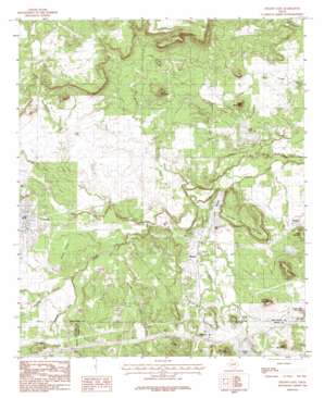
Strawn East Topo Map Texas
To zoom in, hover over the map of Strawn East
USGS Topo Quad 32098e4 - 1:24,000 scale
| Topo Map Name: | Strawn East |
| USGS Topo Quad ID: | 32098e4 |
| Print Size: | ca. 21 1/4" wide x 27" high |
| Southeast Coordinates: | 32.5° N latitude / 98.375° W longitude |
| Map Center Coordinates: | 32.5625° N latitude / 98.4375° W longitude |
| U.S. State: | TX |
| Filename: | o32098e4.jpg |
| Download Map JPG Image: | Strawn East topo map 1:24,000 scale |
| Map Type: | Topographic |
| Topo Series: | 7.5´ |
| Map Scale: | 1:24,000 |
| Source of Map Images: | United States Geological Survey (USGS) |
| Alternate Map Versions: |
Strawn East TX 1984, updated 1984 Download PDF Buy paper map Strawn East TX 2010 Download PDF Buy paper map Strawn East TX 2012 Download PDF Buy paper map Strawn East TX 2016 Download PDF Buy paper map |
1:24,000 Topo Quads surrounding Strawn East
> Back to 32098e1 at 1:100,000 scale
> Back to 32098a1 at 1:250,000 scale
> Back to U.S. Topo Maps home
Strawn East topo map: Gazetteer
Strawn East: Airports
Thurber Lake Airport elevation 341m 1118′Strawn East: Dams
Gordon City Reservoir Dam elevation 296m 971′Lake C B Long Dam elevation 282m 925′
Mingus Lake Dam elevation 296m 971′
Thurber Lake Dam elevation 315m 1033′
Thurber Lake Number 2 Dam elevation 323m 1059′
Thurber Lake Number 3 Dam elevation 311m 1020′
Strawn East: Lakes
Lake C B Long elevation 281m 921′Little Lake elevation 323m 1059′
Strawn East: Oilfields
Boles Rector Oil Field elevation 300m 984′Strawn East: Populated Places
Lyra elevation 294m 964′Mingus elevation 290m 951′
Strawn elevation 306m 1003′
Thurber elevation 314m 1030′
Strawn East: Reservoirs
Gordon City Reservoir elevation 296m 971′Lake C B Long elevation 282m 925′
Lake Mingus elevation 285m 935′
Thurber Lake elevation 315m 1033′
Thurber Lake Number 2 elevation 323m 1059′
Thurber Lake Number 3 elevation 311m 1020′
Strawn East: Ridges
Skunk Ridge elevation 314m 1030′Strawn East: Streams
Bear Creek elevation 299m 980′Edwards Branch elevation 289m 948′
Gilmore Creek elevation 302m 990′
Middle Creek elevation 296m 971′
Panther Creek elevation 275m 902′
Rocky Creek elevation 275m 902′
South Fork Palo Pinto Creek elevation 287m 941′
Turkey Creek elevation 290m 951′
Walnut Creek elevation 287m 941′
Strawn East: Summits
Brushy Mountain elevation 365m 1197′Coal Mine Mountain elevation 359m 1177′
Dairy Mountain elevation 363m 1190′
Dickson-Walker Mountain elevation 341m 1118′
Fox Mountain elevation 306m 1003′
Italian Hill elevation 340m 1115′
New York Hill elevation 350m 1148′
Roundtop Mountain elevation 342m 1122′
Steam Shovel Mountain elevation 317m 1040′
Stump Hill elevation 353m 1158′
Tater Hill elevation 299m 980′
Wilbar Mountain elevation 352m 1154′
Wolf Mountain elevation 351m 1151′
Strawn East digital topo map on disk
Buy this Strawn East topo map showing relief, roads, GPS coordinates and other geographical features, as a high-resolution digital map file on DVD:


