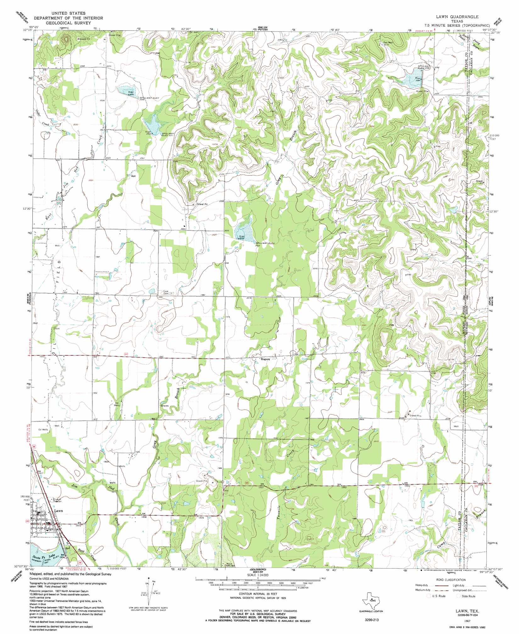
Lawn Topo Map Texas
To zoom in, hover over the map of Lawn
USGS Topo Quad 32099b6 - 1:24,000 scale
| Topo Map Name: | Lawn |
| USGS Topo Quad ID: | 32099b6 |
| Print Size: | ca. 21 1/4" wide x 27" high |
| Southeast Coordinates: | 32.125° N latitude / 99.625° W longitude |
| Map Center Coordinates: | 32.1875° N latitude / 99.6875° W longitude |
| U.S. State: | TX |
| Filename: | o32099b6.jpg |
| Download Map JPG Image: | Lawn topo map 1:24,000 scale |
| Map Type: | Topographic |
| Topo Series: | 7.5´ |
| Map Scale: | 1:24,000 |
| Source of Map Images: | United States Geological Survey (USGS) |
| Alternate Map Versions: |
Lawn TX 1967, updated 1970 Download PDF Buy paper map Lawn TX 1967, updated 1991 Download PDF Buy paper map Lawn TX 2010 Download PDF Buy paper map Lawn TX 2012 Download PDF Buy paper map Lawn TX 2016 Download PDF Buy paper map |
1:24,000 Topo Quads surrounding Lawn
Merkel East |
Abilene West |
Abilene East |
Kirby Lake Ne |
Baird |
View |
Buffalo Gap |
Potosi |
Eula |
Cub Hollow |
Lake Abilene |
Tuscola |
Lawn |
Oplin |
Rowden Nw |
Bradshaw |
Bald Knob |
Goldsboro |
Mcewen Draw |
Crooked Creek |
Winters |
Crews |
Novice West |
Novice East |
Lake Scarborough |
> Back to 32099a1 at 1:100,000 scale
> Back to 32098a1 at 1:250,000 scale
> Back to U.S. Topo Maps home
Lawn topo map: Gazetteer
Lawn: Dams
Lake Lawn Dam elevation 578m 1896′Soil Conservation Service Site 15 Dam elevation 617m 2024′
Soil Conservation Service Site 16 Dam elevation 629m 2063′
Soil Conservation Service Site 17 Dam elevation 627m 2057′
Soil Conservation Service Site 3 Dam elevation 637m 2089′
Lawn: Populated Places
Lawn elevation 584m 1916′Rogers elevation 615m 2017′
Lawn: Reservoirs
Lake Lawn elevation 578m 1896′Santa Fe Lake elevation 579m 1899′
Soil Conservation Service Site 15 Reservoir elevation 617m 2024′
Soil Conservation Service Site 16 Reservoir elevation 629m 2063′
Soil Conservation Service Site 17 Reservoir elevation 627m 2057′
Soil Conservation Service Site 3 Reservoir elevation 637m 2089′
Lawn: Streams
Gray Branch elevation 573m 1879′Lawn digital topo map on disk
Buy this Lawn topo map showing relief, roads, GPS coordinates and other geographical features, as a high-resolution digital map file on DVD: