Lake Abilene Topo Map Texas
To zoom in, hover over the map of Lake Abilene
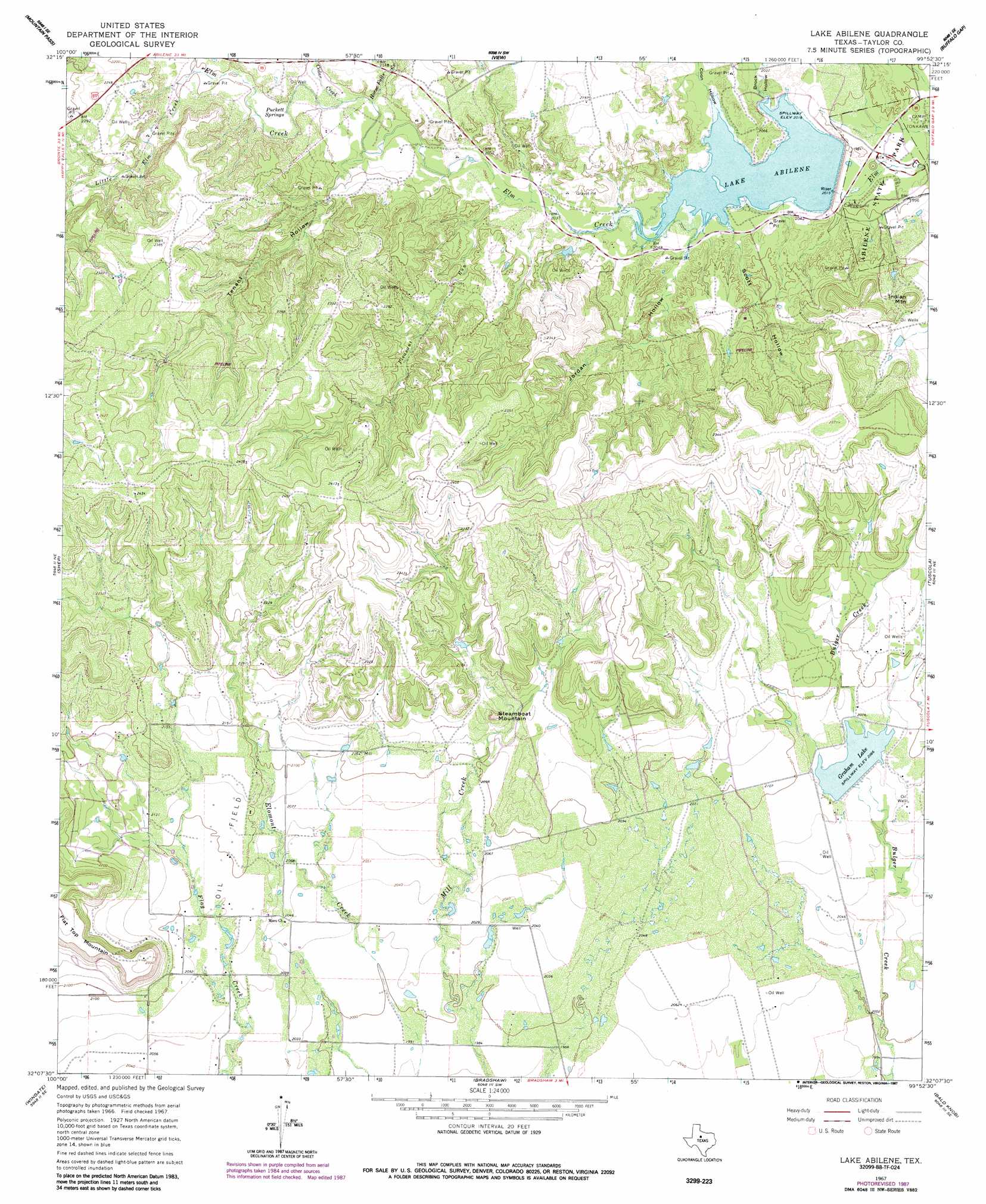
USGS Topo Quad 32099b8 - 1:24,000 scale
| Topo Map Name: | Lake Abilene |
| USGS Topo Quad ID: | 32099b8 |
| Print Size: | ca. 21 1/4" wide x 27" high |
| Southeast Coordinates: | 32.125° N latitude / 99.875° W longitude |
| Map Center Coordinates: | 32.1875° N latitude / 99.9375° W longitude |
| U.S. State: | TX |
| Filename: | o32099b8.jpg |
| Download Map JPG Image: | Lake Abilene topo map 1:24,000 scale |
| Map Type: | Topographic |
| Topo Series: | 7.5´ |
| Map Scale: | 1:24,000 |
| Source of Map Images: | United States Geological Survey (USGS) |
| Alternate Map Versions: |
Lake Abilene TX 1967, updated 1970 Download PDF Buy paper map Lake Abilene TX 1967, updated 1984 Download PDF Buy paper map Lake Abilene TX 1967, updated 1987 Download PDF Buy paper map Lake Abilene TX 2010 Download PDF Buy paper map Lake Abilene TX 2012 Download PDF Buy paper map Lake Abilene TX 2016 Download PDF Buy paper map |
1:24,000 Topo Quads surrounding Lake Abilene
Chalk Peak |
Merkel West |
Merkel East |
Abilene West |
Abilene East |
Nolan |
Mountain Pass |
View |
Buffalo Gap |
Potosi |
Hylton |
Shep |
Lake Abilene |
Tuscola |
Lawn |
Church Peak |
Wingate |
Bradshaw |
Bald Knob |
Goldsboro |
Hog Mountain |
Wilmeth |
Winters |
Crews |
Novice West |
> Back to 32099a1 at 1:100,000 scale
> Back to 32098a1 at 1:250,000 scale
> Back to U.S. Topo Maps home
Lake Abilene topo map: Gazetteer
Lake Abilene: Dams
Lake Abilene Dam elevation 614m 2014′Lake Bulger Dam elevation 630m 2066′
Lake Abilene: Parks
Abilene State Park elevation 602m 1975′Lake Abilene: Reservoirs
Graham Lake elevation 629m 2063′Lake Abilene elevation 615m 2017′
Lake Bulger elevation 630m 2066′
Lake Abilene: Springs
Puckett Springs elevation 634m 2080′Lake Abilene: Streams
Cedar Creek elevation 633m 2076′Horse Fall Creek elevation 631m 2070′
Little Elm Creek elevation 640m 2099′
Pleasant Run elevation 621m 2037′
Lake Abilene: Summits
Indian Mountain elevation 696m 2283′Steamboat Mountain elevation 683m 2240′
Lake Abilene: Trails
Abilene State Park Trail elevation 602m 1975′Lake Abilene: Valleys
Brock Hollow elevation 614m 2014′Coon Hollow elevation 614m 2014′
Jordan Hollow elevation 620m 2034′
Scott Hollow elevation 616m 2020′
Tenant Hollow elevation 632m 2073′
Lake Abilene digital topo map on disk
Buy this Lake Abilene topo map showing relief, roads, GPS coordinates and other geographical features, as a high-resolution digital map file on DVD: