Fort Griffin Topo Map Texas
To zoom in, hover over the map of Fort Griffin
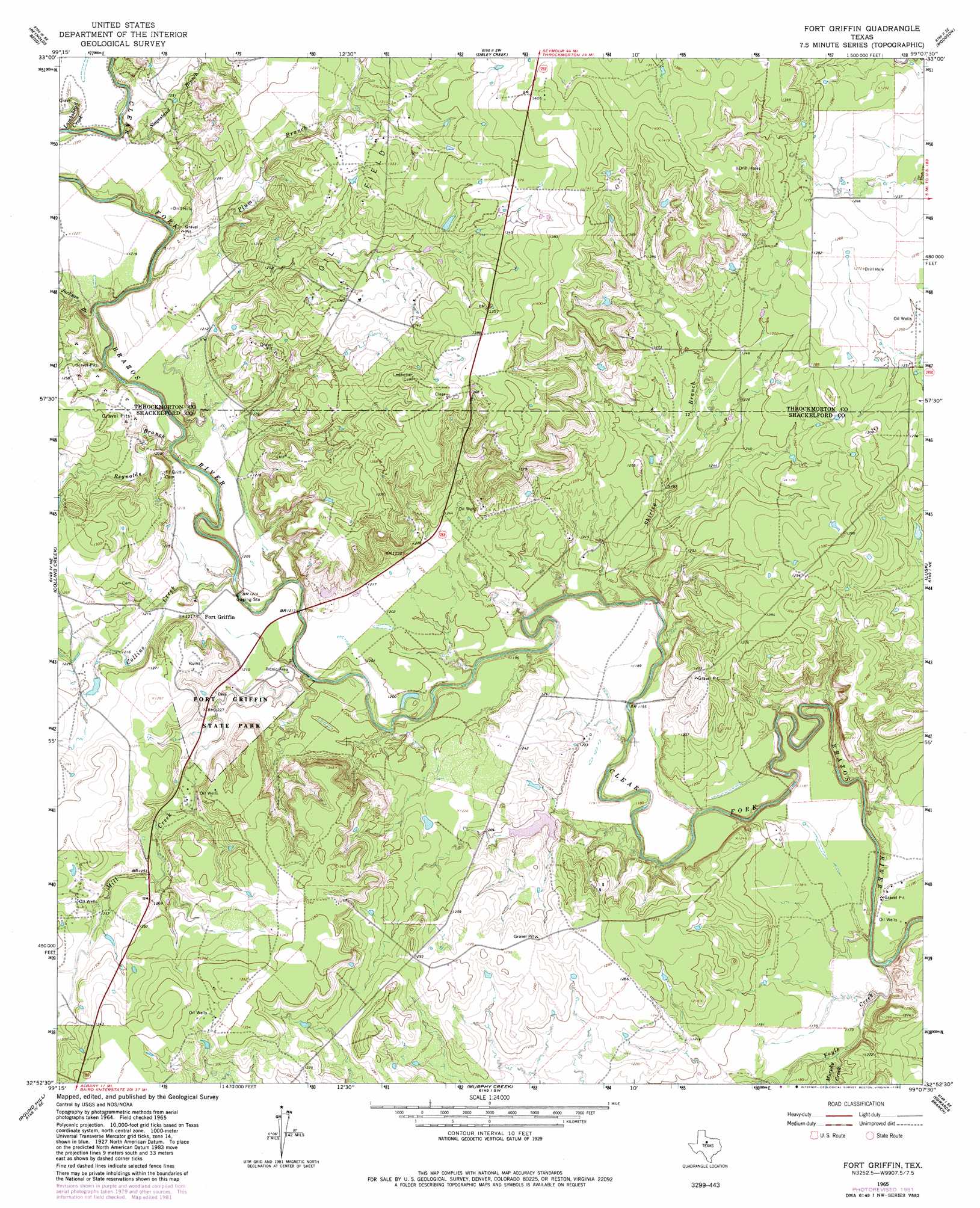
USGS Topo Quad 32099h2 - 1:24,000 scale
| Topo Map Name: | Fort Griffin |
| USGS Topo Quad ID: | 32099h2 |
| Print Size: | ca. 21 1/4" wide x 27" high |
| Southeast Coordinates: | 32.875° N latitude / 99.125° W longitude |
| Map Center Coordinates: | 32.9375° N latitude / 99.1875° W longitude |
| U.S. State: | TX |
| Filename: | o32099h2.jpg |
| Download Map JPG Image: | Fort Griffin topo map 1:24,000 scale |
| Map Type: | Topographic |
| Topo Series: | 7.5´ |
| Map Scale: | 1:24,000 |
| Source of Map Images: | United States Geological Survey (USGS) |
| Alternate Map Versions: |
Fort Griffin TX 1965, updated 1967 Download PDF Buy paper map Fort Griffin TX 1965, updated 1982 Download PDF Buy paper map Fort Griffin TX 2010 Download PDF Buy paper map Fort Griffin TX 2012 Download PDF Buy paper map Fort Griffin TX 2016 Download PDF Buy paper map |
1:24,000 Topo Quads surrounding Fort Griffin
Reynolds Bend Nw |
Tonk Creek |
Throckmorton |
Throckmorton Ne |
Proffitt Crossing |
Hoover Mountain |
Reynolds Bend |
Sibley Creek |
Woodson |
Murray |
Antelope Hills |
Collins Creek |
Fort Griffin |
Lusk |
Crystal Falls |
Collins Creek Sw |
Round Hill |
Murphy Creek |
Edwards Branch |
Breckenridge |
Acampo |
Albany |
Mccathrine Mountain |
Eolian |
Buck Mountain |
> Back to 32099e1 at 1:100,000 scale
> Back to 32098a1 at 1:250,000 scale
> Back to U.S. Topo Maps home
Fort Griffin topo map: Gazetteer
Fort Griffin: Bridges
Fort Griffin Brazos River Bridge elevation 358m 1174′State Highway 23 Bridge elevation 357m 1171′
Fort Griffin: Dams
McCowan Lake Dam elevation 363m 1190′Taylor Lake Dam elevation 377m 1236′
Fort Griffin: Parks
Fort Griffin State Historical Park elevation 368m 1207′Fort Griffin State Park elevation 366m 1200′
Fort Griffin: Populated Places
Fort Griffin elevation 370m 1213′Fort Griffin: Reservoirs
McCowan Lake elevation 363m 1190′Taylor Lake elevation 377m 1236′
Fort Griffin: Streams
Collins Creek elevation 359m 1177′Foyle Creek elevation 348m 1141′
Jackson Branch elevation 361m 1184′
Lambshead Creek elevation 364m 1194′
Mill Creek elevation 356m 1167′
Murphy Creek elevation 352m 1154′
Plum Branch elevation 361m 1184′
Reynolds Branch elevation 361m 1184′
Shirley Branch elevation 352m 1154′
Stagestand Branch elevation 364m 1194′
Fort Griffin: Trails
Fort Griffin State Historical Park Trail elevation 365m 1197′Fort Griffin digital topo map on disk
Buy this Fort Griffin topo map showing relief, roads, GPS coordinates and other geographical features, as a high-resolution digital map file on DVD: