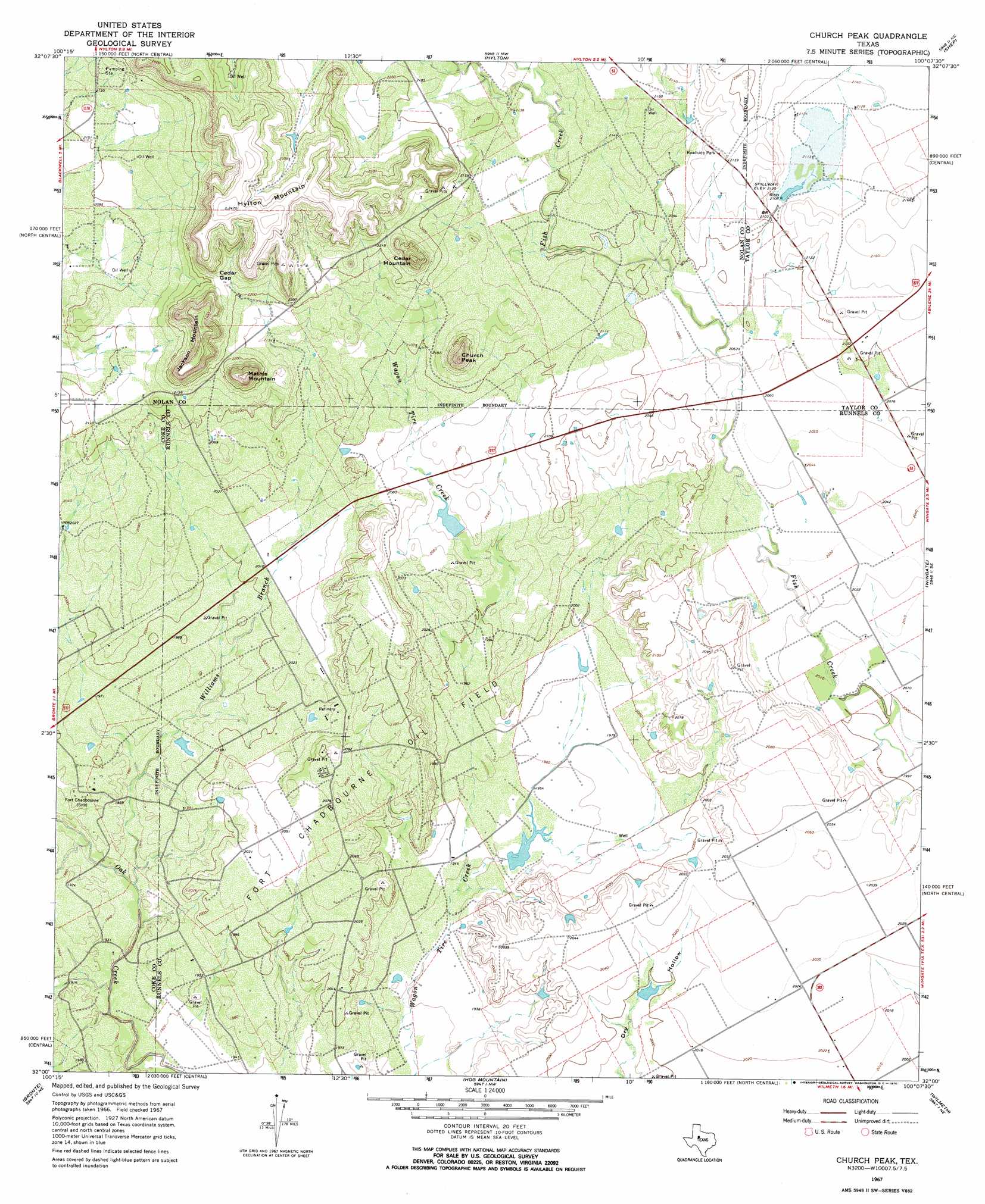
Church Peak Topo Map Texas
To zoom in, hover over the map of Church Peak
USGS Topo Quad 32100a2 - 1:24,000 scale
| Topo Map Name: | Church Peak |
| USGS Topo Quad ID: | 32100a2 |
| Print Size: | ca. 21 1/4" wide x 27" high |
| Southeast Coordinates: | 32° N latitude / 100.125° W longitude |
| Map Center Coordinates: | 32.0625° N latitude / 100.1875° W longitude |
| U.S. State: | TX |
| Filename: | o32100a2.jpg |
| Download Map JPG Image: | Church Peak topo map 1:24,000 scale |
| Map Type: | Topographic |
| Topo Series: | 7.5´ |
| Map Scale: | 1:24,000 |
| Source of Map Images: | United States Geological Survey (USGS) |
| Alternate Map Versions: |
Church Peak TX 1967, updated 1969 Download PDF Buy paper map Church Peak TX 1967, updated 1970 Download PDF Buy paper map Church Peak TX 2010 Download PDF Buy paper map Church Peak TX 2012 Download PDF Buy paper map Church Peak TX 2016 Download PDF Buy paper map |
1:24,000 Topo Quads surrounding Church Peak
Lake Trammell |
Holder Creek |
Nolan |
Mountain Pass |
View |
Maryneal |
Blackwell Ne |
Hylton |
Shep |
Lake Abilene |
Blackwell Sw |
Blackwell |
Church Peak |
Wingate |
Bradshaw |
Robert Lee |
Bronte |
Hog Mountain |
Wilmeth |
Winters |
Cement Mountain |
Shawville |
Maverick |
Herring Ranch |
Hatchel |
> Back to 32100a1 at 1:100,000 scale
> Back to 32100a1 at 1:250,000 scale
> Back to U.S. Topo Maps home
Church Peak topo map: Gazetteer
Church Peak: Dams
Odom Currie Wylie Estate Lake Number 1 Dam elevation 621m 2037′Odom Currie Wylie Estate Lake Number 2 Dam elevation 592m 1942′
Soil Conservation Service Site 1 Dam elevation 636m 2086′
Soil Conservation Service Site 2a Dam elevation 651m 2135′
Soil Conservation Service Site 3 Dam elevation 650m 2132′
Church Peak: Gaps
Cedar Gap elevation 679m 2227′Church Peak: Oilfields
Fort Chadbourne Oil Field elevation 619m 2030′Church Peak: Parks
Fort Chadbourne elevation 605m 1984′Church Peak: Reservoirs
Odom Currie Wylie Estate Lake Number 1 elevation 621m 2037′Odom Currie Wylie Estate Lake Number 2 elevation 592m 1942′
Soil Conservation Service Site 1 Reservoir elevation 636m 2086′
Soil Conservation Service Site 2a Reservoir elevation 651m 2135′
Soil Conservation Service Site 3 Reservoir elevation 650m 2132′
Church Peak: Streams
Williams Branch elevation 585m 1919′Church Peak: Summits
Cedar Mountain elevation 717m 2352′Church Peak elevation 698m 2290′
Hylton Mountain elevation 753m 2470′
Jackson Mountain elevation 741m 2431′
Mathis Mountain elevation 740m 2427′
Church Peak digital topo map on disk
Buy this Church Peak topo map showing relief, roads, GPS coordinates and other geographical features, as a high-resolution digital map file on DVD: