Cedar Bend Topo Map Texas
To zoom in, hover over the map of Cedar Bend
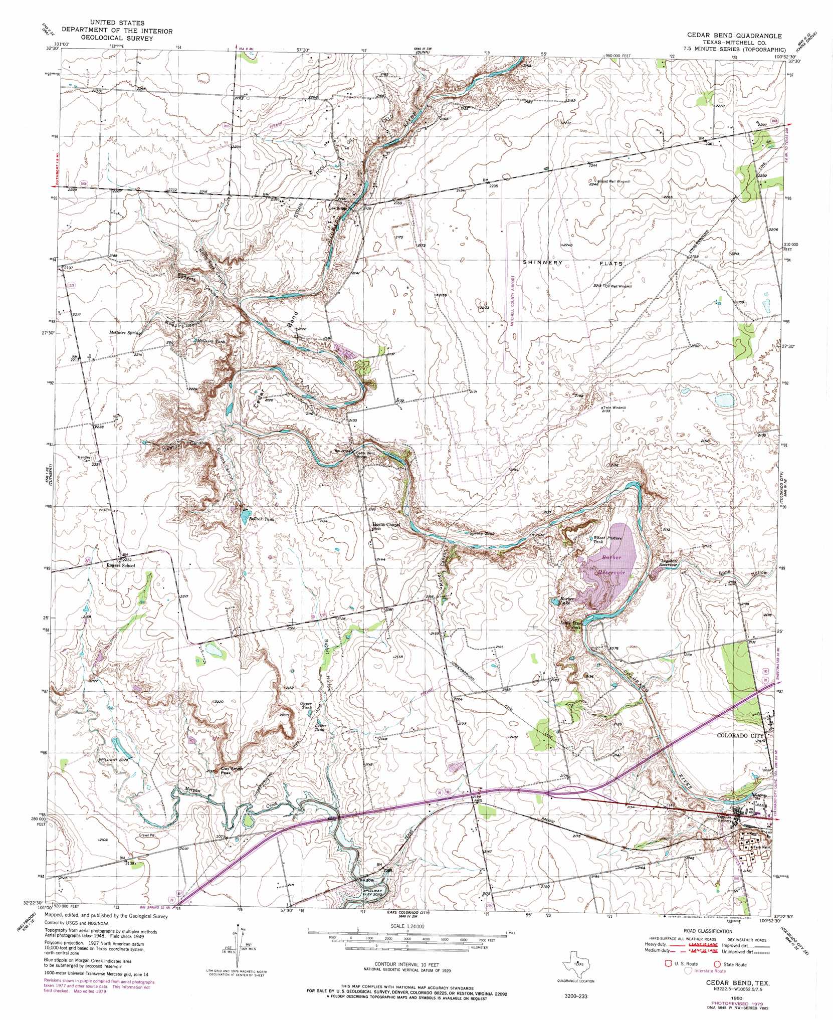
USGS Topo Quad 32100d8 - 1:24,000 scale
| Topo Map Name: | Cedar Bend |
| USGS Topo Quad ID: | 32100d8 |
| Print Size: | ca. 21 1/4" wide x 27" high |
| Southeast Coordinates: | 32.375° N latitude / 100.875° W longitude |
| Map Center Coordinates: | 32.4375° N latitude / 100.9375° W longitude |
| U.S. State: | TX |
| Filename: | o32100d8.jpg |
| Download Map JPG Image: | Cedar Bend topo map 1:24,000 scale |
| Map Type: | Topographic |
| Topo Series: | 7.5´ |
| Map Scale: | 1:24,000 |
| Source of Map Images: | United States Geological Survey (USGS) |
| Alternate Map Versions: |
Cedar Bend TX 1950 Download PDF Buy paper map Cedar Bend TX 1950, updated 1977 Download PDF Buy paper map Cedar Bend TX 1950, updated 1980 Download PDF Buy paper map Cedar Bend TX 2010 Download PDF Buy paper map Cedar Bend TX 2012 Download PDF Buy paper map Cedar Bend TX 2016 Download PDF Buy paper map |
1:24,000 Topo Quads surrounding Cedar Bend
Ira Nw |
Ira Ne |
Snyder |
Hermleigh |
Inadale Nw |
Ira Sw |
Ira |
Dunn |
China Grove |
Inadale |
Vincent |
Cuthbert |
Cedar Bend |
Colorado City |
Loraine |
Iatan |
Westbrook |
Lake Colorado City |
Colorado City Se |
Baumann School |
Hyman |
Hyman Ne |
Spade Ranch |
Pecan Crossing |
Dam Draw |
> Back to 32100a1 at 1:100,000 scale
> Back to 32100a1 at 1:250,000 scale
> Back to U.S. Topo Maps home
Cedar Bend topo map: Gazetteer
Cedar Bend: Airports
Colorado City Airport elevation 674m 2211′Cedar Bend: Bends
Cedar Bend elevation 648m 2125′Cedar Bend: Bridges
Cedar Bend Bridge elevation 628m 2060′Low Bridge elevation 637m 2089′
Cedar Bend: Dams
Colorado River Off Channel Storage Dam elevation 634m 2080′Cedar Bend: Flats
Shinnery Flats elevation 683m 2240′Cedar Bend: Lakes
Little Blue Hole elevation 623m 2043′Cedar Bend: Oilfields
Strain Pool Oil Field elevation 664m 2178′Cedar Bend: Reservoirs
Barber Lake elevation 649m 2129′Bullock Tank elevation 641m 2103′
Colorado River Storage Reservoir elevation 634m 2080′
Logsdon Reservoir elevation 632m 2073′
Lower Tank elevation 639m 2096′
McGuire Tank elevation 658m 2158′
Upper Tank elevation 643m 2109′
Wheat Pasture Tank elevation 645m 2116′
Cedar Bend: Springs
McGuire Spring elevation 672m 2204′Cedar Bend: Summits
Clay Smith Peak elevation 651m 2135′Cedar Bend: Valleys
Badgett Canyon elevation 637m 2089′Bone Hollow elevation 634m 2080′
Bullock Canyon elevation 633m 2076′
Dawson Canyon elevation 633m 2076′
McGuire Canyon elevation 638m 2093′
Moser Canyon elevation 628m 2060′
North Fork Canyon elevation 637m 2089′
Rabbit Hollow elevation 631m 2070′
Cedar Bend digital topo map on disk
Buy this Cedar Bend topo map showing relief, roads, GPS coordinates and other geographical features, as a high-resolution digital map file on DVD: