Javelina Basin Topo Map New Mexico
To zoom in, hover over the map of Javelina Basin
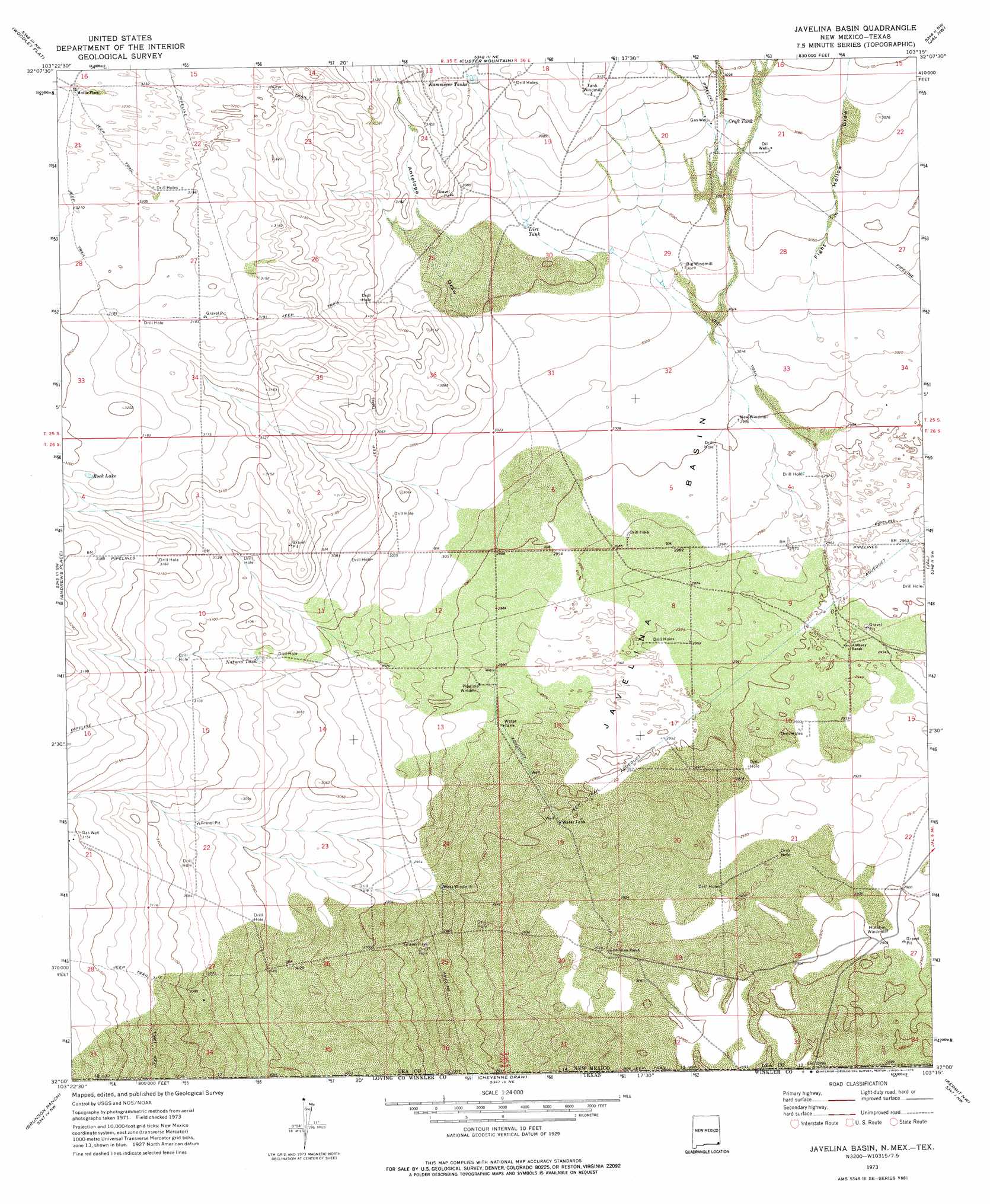
USGS Topo Quad 32103a3 - 1:24,000 scale
| Topo Map Name: | Javelina Basin |
| USGS Topo Quad ID: | 32103a3 |
| Print Size: | ca. 21 1/4" wide x 27" high |
| Southeast Coordinates: | 32° N latitude / 103.25° W longitude |
| Map Center Coordinates: | 32.0625° N latitude / 103.3125° W longitude |
| U.S. States: | NM, TX |
| Filename: | o32103a3.jpg |
| Download Map JPG Image: | Javelina Basin topo map 1:24,000 scale |
| Map Type: | Topographic |
| Topo Series: | 7.5´ |
| Map Scale: | 1:24,000 |
| Source of Map Images: | United States Geological Survey (USGS) |
| Alternate Map Versions: |
Javelina Basin NM 1973, updated 1975 Download PDF Buy paper map Javelina Basin NM 2010 Download PDF Buy paper map Javelina Basin NM 2013 Download PDF Buy paper map Javelina Basin NM 2017 Download PDF Buy paper map |
1:24,000 Topo Quads surrounding Javelina Basin
Tip Top Wells |
San Simon Sink |
East Lake |
Rattlesnake Canyon |
Eunice Se |
Bell Lake |
Woodley Flat |
Custer Mountain |
Jal Nw |
Jal Ne |
Paduca Breaks East |
Andrews Place |
Javelina Basin |
Jal |
Jal Se |
Rudd Draw Ne |
Brunson Ranch |
Cheyenne Draw |
Kermit Nw |
Vesrue |
Rudd Draw |
Cheyenne Draw Sw |
Cheyenne Draw Se |
Wink North |
Kermit |
> Back to 32103a1 at 1:100,000 scale
> Back to 32102a1 at 1:250,000 scale
> Back to U.S. Topo Maps home
Javelina Basin topo map: Gazetteer
Javelina Basin: Basins
Javelina Basin elevation 908m 2979′Javelina Basin: Lakes
Rock Lake elevation 972m 3188′Javelina Basin: Populated Places
Medlin Place elevation 985m 3231′Javelina Basin: Reservoirs
Croft Tank elevation 938m 3077′Dirt Tank elevation 932m 3057′
Kammerer Tanks elevation 945m 3100′
Natural Tank elevation 936m 3070′
Javelina Basin: Valleys
Antelope Draw elevation 927m 3041′Fight in Hollow Draw elevation 921m 3021′
Javelina Basin: Wells
10117 Water Well elevation 940m 3083′11570 Water Well elevation 909m 2982′
11571 Water Well elevation 897m 2942′
11573 Water Well elevation 906m 2972′
11574 Water Well elevation 906m 2972′
11575 Water Well elevation 906m 2972′
11576 Water Well elevation 897m 2942′
11578 Water Well elevation 884m 2900′
11604 Water Well elevation 945m 3100′
11605 Water Well elevation 945m 3100′
11606 Water Well elevation 985m 3231′
11616 Water Well elevation 914m 2998′
12958 Water Well elevation 909m 2982′
12959 Water Well elevation 904m 2965′
13634 Water Well elevation 986m 3234′
Javelina Basin digital topo map on disk
Buy this Javelina Basin topo map showing relief, roads, GPS coordinates and other geographical features, as a high-resolution digital map file on DVD: