Humble City Nw Topo Map New Mexico
To zoom in, hover over the map of Humble City Nw
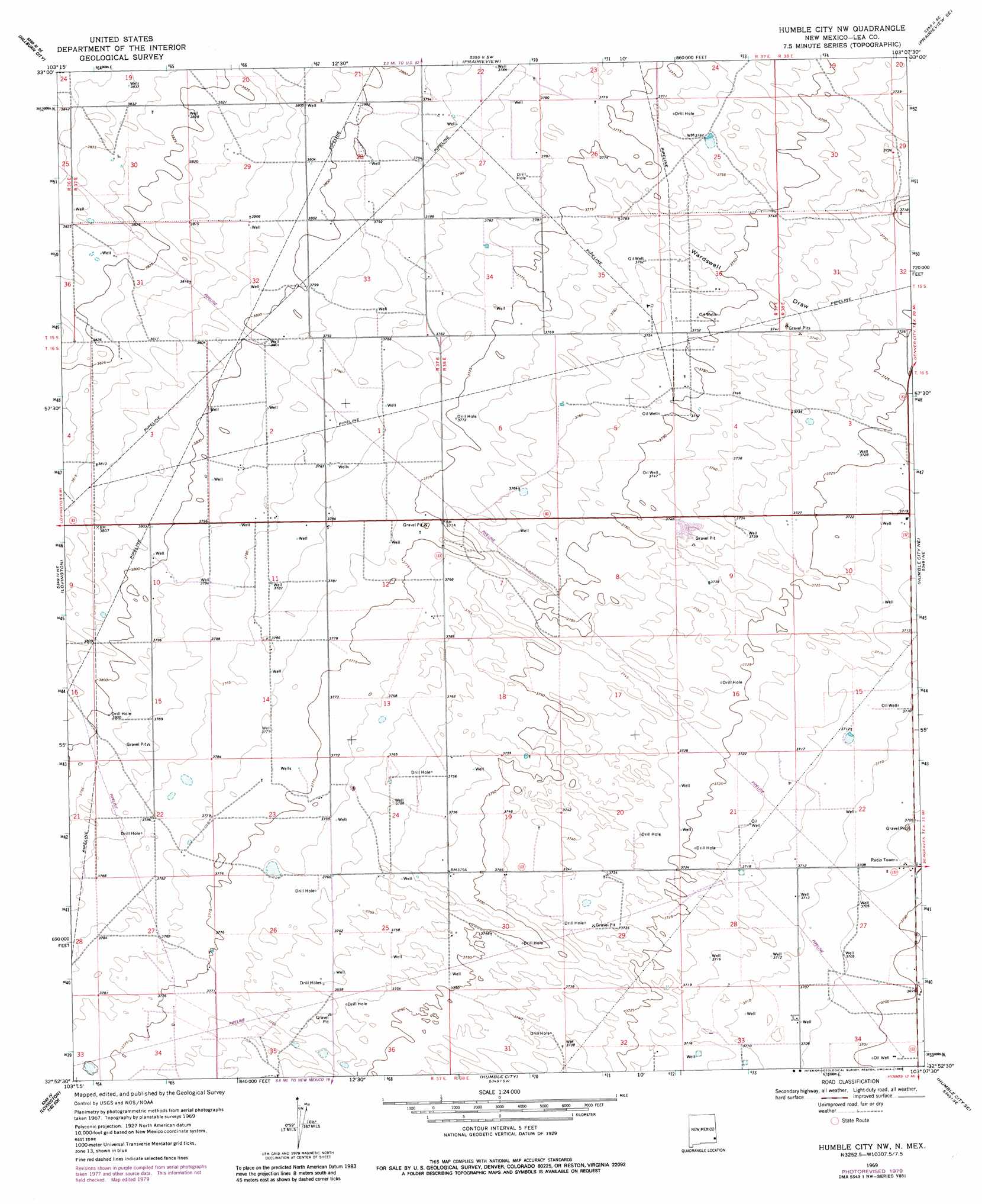
USGS Topo Quad 32103h2 - 1:24,000 scale
| Topo Map Name: | Humble City Nw |
| USGS Topo Quad ID: | 32103h2 |
| Print Size: | ca. 21 1/4" wide x 27" high |
| Southeast Coordinates: | 32.875° N latitude / 103.125° W longitude |
| Map Center Coordinates: | 32.9375° N latitude / 103.1875° W longitude |
| U.S. State: | NM |
| Filename: | o32103h2.jpg |
| Download Map JPG Image: | Humble City Nw topo map 1:24,000 scale |
| Map Type: | Topographic |
| Topo Series: | 7.5´ |
| Map Scale: | 1:24,000 |
| Source of Map Images: | United States Geological Survey (USGS) |
| Alternate Map Versions: |
Humble City NW NM 2010 Download PDF Buy paper map Humble City NW NM 2013 Download PDF Buy paper map Humble City NW NM 2017 Download PDF Buy paper map |
1:24,000 Topo Quads surrounding Humble City Nw
Alston Ranch |
Tatum South |
Prairieview Nw |
Prairieview Ne |
Plains Nw |
Hillburn City Sw |
Hillburn City |
Prairieview |
Prairieview Se |
Ink Basin |
Lovington Nw |
Lovington |
Humble City Nw |
Humble City Ne |
Higginbotham |
Lovington Sw |
Lovington Se |
Humble City |
Humble City Se |
Denver City Sw |
Ironhouse Draw |
Monument North |
Hobbs West |
Hobbs East |
Paynes Corner Nw |
> Back to 32103e1 at 1:100,000 scale
> Back to 32102a1 at 1:250,000 scale
> Back to U.S. Topo Maps home
Humble City Nw topo map: Gazetteer
Humble City Nw: Mines
New Mexico Project Number SP-2-76 elevation 1141m 3743′Humble City Nw: Wells
10144 Water Well elevation 1170m 3838′10146 Water Well elevation 1159m 3802′
10148 Water Well elevation 1155m 3789′
10149 Water Well elevation 1161m 3809′
10150 Water Well elevation 1164m 3818′
10151 Water Well elevation 1165m 3822′
10152 Water Well elevation 1157m 3795′
10153 Water Well elevation 1155m 3789′
10185 Water Well elevation 1156m 3792′
10186 Water Well elevation 1158m 3799′
10189 Water Well elevation 1154m 3786′
10191 Water Well elevation 1146m 3759′
10192 Water Well elevation 1146m 3759′
10193 Water Well elevation 1151m 3776′
10194 Water Well elevation 1131m 3710′
10195 Water Well elevation 1136m 3727′
10199 Water Well elevation 1131m 3710′
10200 Water Well elevation 1131m 3710′
10201 Water Well elevation 1141m 3743′
10202 Water Well elevation 1129m 3704′
10203 Water Well elevation 1130m 3707′
Humble City Nw digital topo map on disk
Buy this Humble City Nw topo map showing relief, roads, GPS coordinates and other geographical features, as a high-resolution digital map file on DVD: