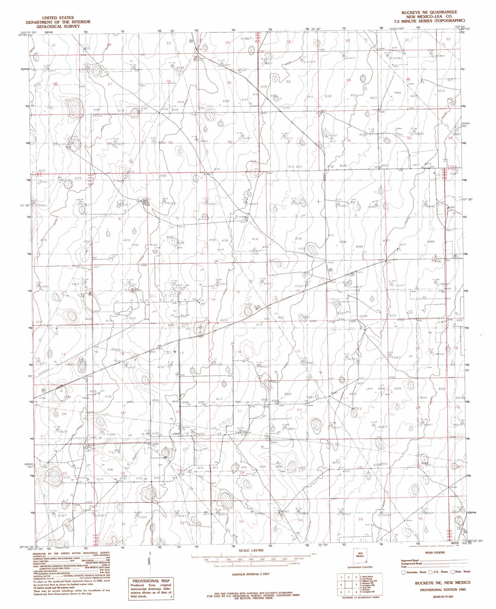
Buckeye Ne Topo Map New Mexico
To zoom in, hover over the map of Buckeye Ne
USGS Topo Quad 32103h5 - 1:24,000 scale
| Topo Map Name: | Buckeye Ne |
| USGS Topo Quad ID: | 32103h5 |
| Print Size: | ca. 21 1/4" wide x 27" high |
| Southeast Coordinates: | 32.875° N latitude / 103.5° W longitude |
| Map Center Coordinates: | 32.9375° N latitude / 103.5625° W longitude |
| U.S. State: | NM |
| Filename: | o32103h5.jpg |
| Download Map JPG Image: | Buckeye Ne topo map 1:24,000 scale |
| Map Type: | Topographic |
| Topo Series: | 7.5´ |
| Map Scale: | 1:24,000 |
| Source of Map Images: | United States Geological Survey (USGS) |
| Alternate Map Versions: |
Buckeye NE NM 1985, updated 1985 Download PDF Buy paper map Buckeye NE NM 2010 Download PDF Buy paper map Buckeye NE NM 2013 Download PDF Buy paper map Buckeye NE NM 2017 Download PDF Buy paper map |
1:24,000 Topo Quads surrounding Buckeye Ne
Caudill Ranch |
Cooper-Good Ranch |
Frier Ranch |
Alston Ranch |
Tatum South |
Cedar Point Se |
Dean Ranch |
Fort Ranch |
Hillburn City Sw |
Hillburn City |
Maljamar Ne |
Buckeye Nw |
Buckeye Ne |
Lovington Nw |
Lovington |
Maljamar |
Dog Lake |
Buckeye |
Lovington Sw |
Lovington Se |
Greenwood Lake |
Laguna Gatuna Nw |
Ironhouse Well |
Ironhouse Draw |
Monument North |
> Back to 32103e1 at 1:100,000 scale
> Back to 32102a1 at 1:250,000 scale
> Back to U.S. Topo Maps home
Buckeye Ne topo map: Gazetteer
Buckeye Ne: Oilfields
Hume Oil Field elevation 1262m 4140′Kemnitz Oil Field elevation 1266m 4153′
Buckeye Ne: Wells
10158 Water Well elevation 1270m 4166′10159 Water Well elevation 1257m 4124′
11070 Water Well elevation 1266m 4153′
11071 Water Well elevation 1261m 4137′
11080 Water Well elevation 1263m 4143′
11081 Water Well elevation 1238m 4061′
11082 Water Well elevation 1239m 4064′
11084 Water Well elevation 1237m 4058′
11086 Water Well elevation 1246m 4087′
11087 Water Well elevation 1256m 4120′
11088 Water Well elevation 1254m 4114′
11089 Water Well elevation 1269m 4163′
11090 Water Well elevation 1264m 4146′
11091 Water Well elevation 1264m 4146′
11092 Water Well elevation 1259m 4130′
11093 Water Well elevation 1256m 4120′
11094 Water Well elevation 1249m 4097′
11095 Water Well elevation 1245m 4084′
11096 Water Well elevation 1237m 4058′
11097 Water Well elevation 1237m 4058′
11098 Water Well elevation 1238m 4061′
11099 Water Well elevation 1234m 4048′
11100 Water Well elevation 1241m 4071′
11101 Water Well elevation 1250m 4101′
11102 Water Well elevation 1248m 4094′
11103 Water Well elevation 1247m 4091′
11105 Water Well elevation 1245m 4084′
11428 Water Well elevation 1239m 4064′
12391 Water Well elevation 1280m 4199′
12392 Water Well elevation 1259m 4130′
12393 Water Well elevation 1268m 4160′
12395 Water Well elevation 1274m 4179′
12414 Water Well elevation 1252m 4107′
12415 Water Well elevation 1252m 4107′
12416 Water Well elevation 1244m 4081′
12769 Water Well elevation 1274m 4179′
12858 Water Well elevation 1265m 4150′
12859 Water Well elevation 1262m 4140′
12860 Water Well elevation 1234m 4048′
13222 Water Well elevation 1246m 4087′
13307 Water Well elevation 1278m 4192′
13309 Water Well elevation 1266m 4153′
13310 Water Well elevation 1241m 4071′
13325 Water Well elevation 1273m 4176′
13331 Water Well elevation 1247m 4091′
13332 Water Well elevation 1244m 4081′
13333 Water Well elevation 1241m 4071′
Buckeye Ne digital topo map on disk
Buy this Buckeye Ne topo map showing relief, roads, GPS coordinates and other geographical features, as a high-resolution digital map file on DVD: