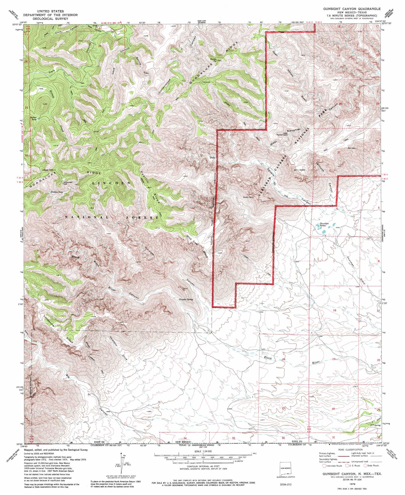
Gunsight Canyon Topo Map New Mexico
To zoom in, hover over the map of Gunsight Canyon
USGS Topo Quad 32104a6 - 1:24,000 scale
| Topo Map Name: | Gunsight Canyon |
| USGS Topo Quad ID: | 32104a6 |
| Print Size: | ca. 21 1/4" wide x 27" high |
| Southeast Coordinates: | 32° N latitude / 104.625° W longitude |
| Map Center Coordinates: | 32.0625° N latitude / 104.6875° W longitude |
| U.S. States: | NM, TX |
| Filename: | o32104a6.jpg |
| Download Map JPG Image: | Gunsight Canyon topo map 1:24,000 scale |
| Map Type: | Topographic |
| Topo Series: | 7.5´ |
| Map Scale: | 1:24,000 |
| Source of Map Images: | United States Geological Survey (USGS) |
| Alternate Map Versions: |
Gunsight Canyon NM 1979, updated 1986 Download PDF Buy paper map Gunsight Canyon NM 2001, updated 2003 Download PDF Buy paper map Gunsight Canyon NM 2011 Download PDF Buy paper map Gunsight Canyon NM 2013 Download PDF Buy paper map Gunsight Canyon NM 2017 Download PDF Buy paper map |
| FStopo: | US Forest Service topo Gunsight Canyon is available: Download FStopo PDF Download FStopo TIF |
1:24,000 Topo Quads surrounding Gunsight Canyon
Algerita Canyon |
Ares Peak |
Red Bluff Draw |
Bandanna Point |
Carnero Peak |
La Paloma Canyon |
Pickett Hill |
Queen |
Serpentine Bends |
Carlsbad Caverns |
Panther Canyon |
El Paso Gap |
Gunsight Canyon |
Grapevine Draw |
Rattlesnake Spring |
P X Flat |
Guadalupe Peak |
Independence Spring |
South Rector Canyon |
Alligator Draw |
Patterson Hills |
Guadalupe Pass |
Long Point |
Cow Mountain |
Delaware Spring |
> Back to 32104a1 at 1:100,000 scale
> Back to 32104a1 at 1:250,000 scale
> Back to U.S. Topo Maps home
Gunsight Canyon topo map: Gazetteer
Gunsight Canyon: Parks
Lonesome Ridge Wilderness Study Area elevation 1984m 6509′Gunsight Canyon: Reservoirs
Helton Tank elevation 1891m 6204′Thurman Tanks elevation 1425m 4675′
Gunsight Canyon: Ridges
Lonesome Ridge elevation 2019m 6624′Pacific Slope elevation 2059m 6755′
Gunsight Canyon: Springs
Aqua Dulce Seep elevation 1781m 5843′Franks Spring elevation 1486m 4875′
Hidden Seep elevation 1946m 6384′
South Seep elevation 1905m 6250′
Spring Seep elevation 1877m 6158′
XT Spring elevation 1326m 4350′
Gunsight Canyon: Streams
Helton Creek elevation 1852m 6076′Gunsight Canyon: Summits
Wild Cow Mesa elevation 1985m 6512′Gunsight Canyon: Trails
Double Trail elevation 1916m 6286′Golden Stairway Trail elevation 1920m 6299′
Ussery Trail elevation 2062m 6765′
Gunsight Canyon: Valleys
Black Canyon elevation 1468m 4816′Calamity Cove elevation 1470m 4822′
Cave Canyon elevation 1764m 5787′
Double Canyon elevation 1419m 4655′
Franks Canyon elevation 1684m 5524′
Goat Canyon elevation 1773m 5816′
Gunsight Canyon elevation 1491m 4891′
Lefthook Canyon elevation 1419m 4655′
Middle Fork Big Canyon elevation 1558m 5111′
North Fork Big Canyon elevation 1555m 5101′
Open Hollow Gulch elevation 1649m 5410′
Spring Canyon elevation 1789m 5869′
Stone Canyon elevation 1797m 5895′
Gunsight Canyon digital topo map on disk
Buy this Gunsight Canyon topo map showing relief, roads, GPS coordinates and other geographical features, as a high-resolution digital map file on DVD: