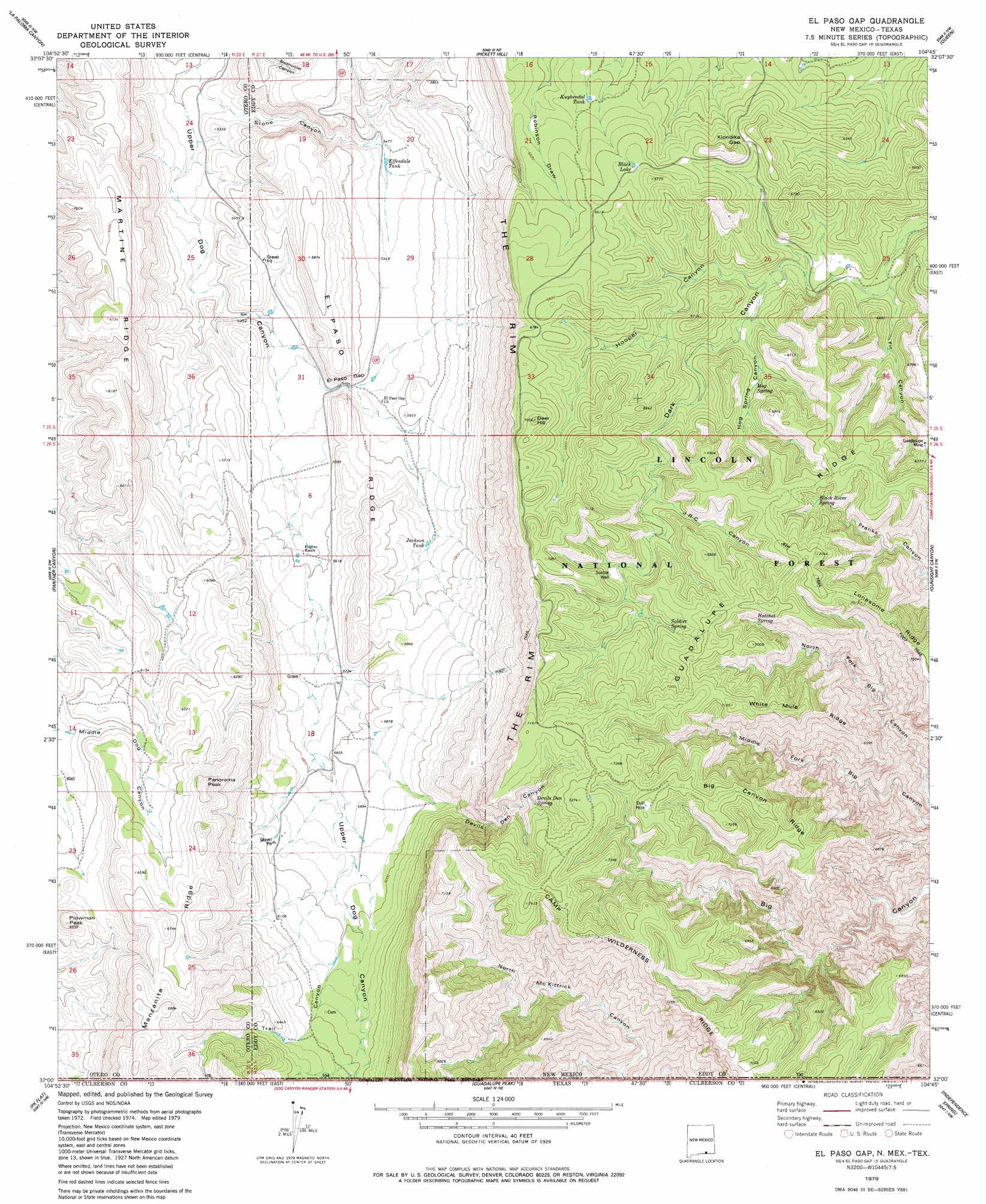
El Paso Gap Topo Map New Mexico
To zoom in, hover over the map of El Paso Gap
USGS Topo Quad 32104a7 - 1:24,000 scale
| Topo Map Name: | El Paso Gap |
| USGS Topo Quad ID: | 32104a7 |
| Print Size: | ca. 21 1/4" wide x 27" high |
| Southeast Coordinates: | 32° N latitude / 104.75° W longitude |
| Map Center Coordinates: | 32.0625° N latitude / 104.8125° W longitude |
| U.S. States: | NM, TX |
| Filename: | o32104a7.jpg |
| Download Map JPG Image: | El Paso Gap topo map 1:24,000 scale |
| Map Type: | Topographic |
| Topo Series: | 7.5´ |
| Map Scale: | 1:24,000 |
| Source of Map Images: | United States Geological Survey (USGS) |
| Alternate Map Versions: |
El Paso Gap NM 1979, updated 1979 Download PDF Buy paper map El Paso Gap NM 2001, updated 2003 Download PDF Buy paper map El Paso Gap NM 2011 Download PDF Buy paper map El Paso Gap NM 2013 Download PDF Buy paper map El Paso Gap NM 2017 Download PDF Buy paper map |
| FStopo: | US Forest Service topo El Paso Gap is available: Download FStopo PDF Download FStopo TIF |
1:24,000 Topo Quads surrounding El Paso Gap
Gowdy Ranch |
Algerita Canyon |
Ares Peak |
Red Bluff Draw |
Bandanna Point |
Sheep Draw |
La Paloma Canyon |
Pickett Hill |
Queen |
Serpentine Bends |
Cienega School |
Panther Canyon |
El Paso Gap |
Gunsight Canyon |
Grapevine Draw |
Linda Lake North |
P X Flat |
Guadalupe Peak |
Independence Spring |
South Rector Canyon |
Linda Lake South |
Patterson Hills |
Guadalupe Pass |
Long Point |
Cow Mountain |
> Back to 32104a1 at 1:100,000 scale
> Back to 32104a1 at 1:250,000 scale
> Back to U.S. Topo Maps home
El Paso Gap topo map: Gazetteer
El Paso Gap: Gaps
El Paso Gap elevation 1674m 5492′Klondike Gap elevation 2000m 6561′
El Paso Gap: Lakes
Black Lake elevation 2034m 6673′El Paso Gap: Mines
Guadalupe Mine elevation 2050m 6725′El Paso Gap: Parks
Devils Den Canyon Wilderness Study Area elevation 1871m 6138′Guadalupe Escarpment Wilderness Study Area elevation 1796m 5892′
McKittrick Canyon Wilderness Study Area elevation 1886m 6187′
Upper McKittrick Canyon Research Natural Area elevation 2007m 6584′
El Paso Gap: Post Offices
El Paso Gap Post Office (historical) elevation 1674m 5492′El Paso Gap: Reservoirs
Black River Storage Tank elevation 2034m 6673′Black River Water Storage elevation 2091m 6860′
Dirt Tank elevation 1942m 6371′
Effendale Tank elevation 1671m 5482′
Hollan Tank elevation 1785m 5856′
Jackson Tank elevation 1734m 5688′
Kuykendal Tank elevation 1966m 6450′
Monzarita Tank elevation 1988m 6522′
Owens Tank elevation 1798m 5898′
Todd Tank elevation 1901m 6236′
El Paso Gap: Ridges
Big Canyon Ridge elevation 2208m 7244′Camp Wilderness Ridge elevation 2256m 7401′
El Paso Ridge elevation 1708m 5603′
Manzanita Ridge elevation 2040m 6692′
Martine Ridge elevation 1833m 6013′
White Mule Ridge elevation 2178m 7145′
El Paso Gap: Springs
Black River Spring elevation 2034m 6673′Devils Den Spring elevation 2114m 6935′
Hatchet Spring elevation 2043m 6702′
Hog Spring elevation 1942m 6371′
JRC Spring elevation 2031m 6663′
Midwater Spring elevation 2035m 6676′
Soldier Spring elevation 2076m 6811′
El Paso Gap: Summits
Deer Hill elevation 2135m 7004′Panorama Peak elevation 2051m 6729′
Plowman Peak elevation 1992m 6535′
El Paso Gap: Valleys
Devils Den Canyon elevation 1826m 5990′Fir Canyon elevation 1875m 6151′
Hog Spring Canyon elevation 1922m 6305′
Hooper Canyon elevation 1900m 6233′
JRC Canyon elevation 1996m 6548′
Shattuck Valley elevation 1669m 5475′
Stone Canyon elevation 1595m 5232′
Trail Canyon elevation 1903m 6243′
Trail Canyon elevation 1819m 5967′
El Paso Gap: Wells
Soldier Well elevation 2043m 6702′El Paso Gap digital topo map on disk
Buy this El Paso Gap topo map showing relief, roads, GPS coordinates and other geographical features, as a high-resolution digital map file on DVD: