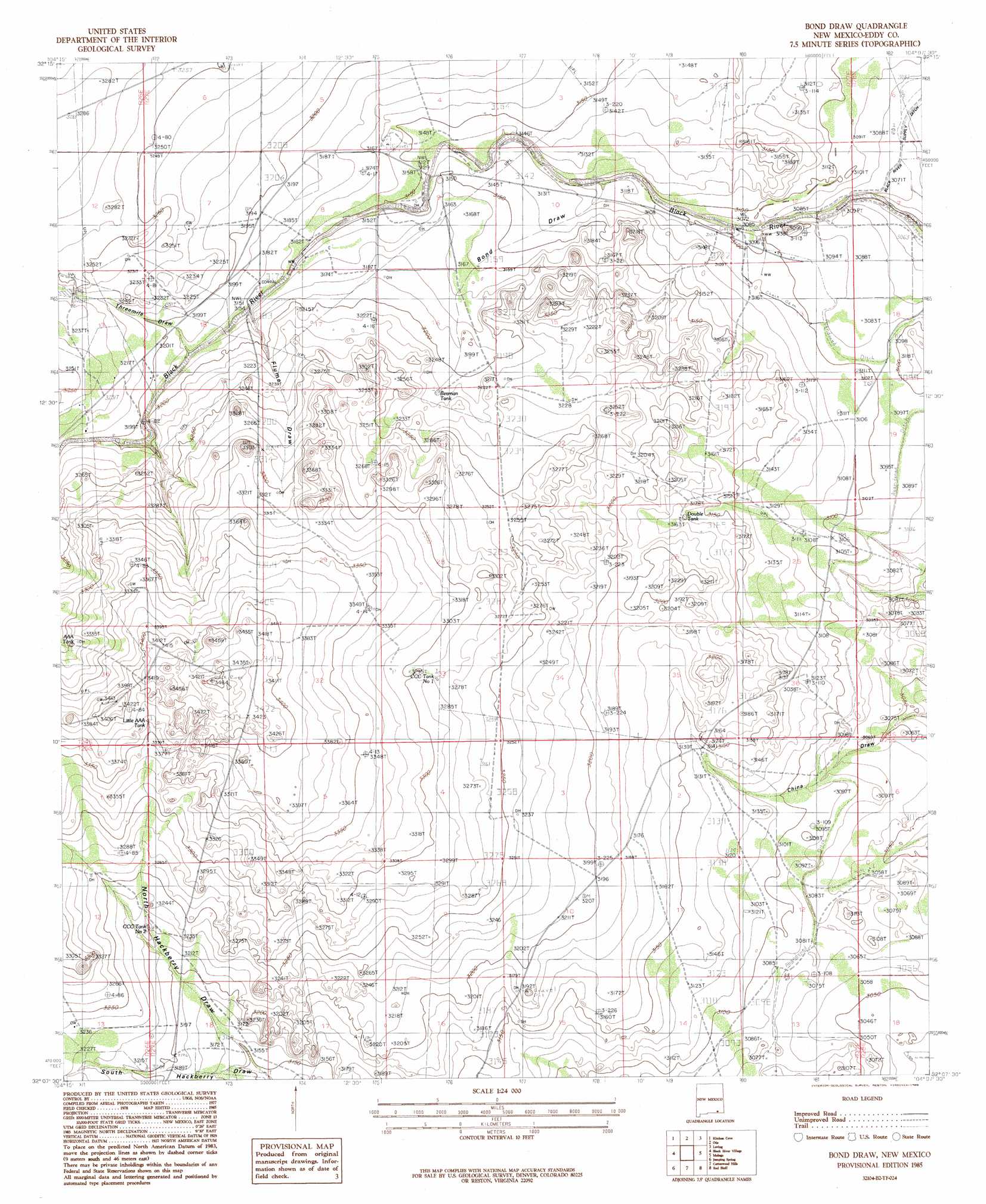
Bond Draw Topo Map New Mexico
To zoom in, hover over the map of Bond Draw
USGS Topo Quad 32104b2 - 1:24,000 scale
| Topo Map Name: | Bond Draw |
| USGS Topo Quad ID: | 32104b2 |
| Print Size: | ca. 21 1/4" wide x 27" high |
| Southeast Coordinates: | 32.125° N latitude / 104.125° W longitude |
| Map Center Coordinates: | 32.1875° N latitude / 104.1875° W longitude |
| U.S. State: | NM |
| Filename: | o32104b2.jpg |
| Download Map JPG Image: | Bond Draw topo map 1:24,000 scale |
| Map Type: | Topographic |
| Topo Series: | 7.5´ |
| Map Scale: | 1:24,000 |
| Source of Map Images: | United States Geological Survey (USGS) |
| Alternate Map Versions: |
Bond Draw NM 1985, updated 1985 Download PDF Buy paper map Bond Draw NM 2010 Download PDF Buy paper map Bond Draw NM 2013 Download PDF Buy paper map Bond Draw NM 2017 Download PDF Buy paper map |
1:24,000 Topo Quads surrounding Bond Draw
Azotea Peak |
Carlsbad West |
Carlsbad East |
Indian Flats |
Tower Hill South |
Carnero Peak |
Kitchen Cove |
Otis |
Loving |
Remuda Basin |
Carlsbad Caverns |
Black River Village |
Bond Draw |
Malaga |
Pierce Canyon |
Rattlesnake Spring |
Jumping Spring |
Cottonwood Hills |
Red Bluff |
Ross Ranch |
Alligator Draw |
Outlaw Spring |
Owl Hills |
Screw Bean Draw Ne |
Red Bluff |
> Back to 32104a1 at 1:100,000 scale
> Back to 32104a1 at 1:250,000 scale
> Back to U.S. Topo Maps home
Bond Draw topo map: Gazetteer
Bond Draw: Populated Places
Harkey Crossing elevation 959m 3146′Bond Draw: Reservoirs
AAA Tank elevation 1005m 3297′Beaman Tank elevation 979m 3211′
CCC Tank Number 1 elevation 1006m 3300′
CCC Tank Number 2 elevation 982m 3221′
Double Tank elevation 964m 3162′
Little AAA Tank elevation 1027m 3369′
Bond Draw: Valleys
Bond Draw elevation 943m 3093′North Hackberry Draw elevation 960m 3149′
South Hackberry Draw elevation 960m 3149′
Threemile Draw elevation 968m 3175′
Bond Draw: Wells
06619 Water Well elevation 975m 3198′06620 Water Well elevation 975m 3198′
06626 Water Well elevation 939m 3080′
20057 Water Well elevation 979m 3211′
20060 Water Well elevation 972m 3188′
20074 Water Well elevation 964m 3162′
20075 Water Well elevation 975m 3198′
20079 Water Well elevation 932m 3057′
20080 Water Well elevation 923m 3028′
Cement Tank Well elevation 950m 3116′
Hackberry Well elevation 976m 3202′
Northwest Well elevation 925m 3034′
Southeast Well elevation 942m 3090′
Bond Draw digital topo map on disk
Buy this Bond Draw topo map showing relief, roads, GPS coordinates and other geographical features, as a high-resolution digital map file on DVD: