Carlsbad Caverns Topo Map New Mexico
To zoom in, hover over the map of Carlsbad Caverns
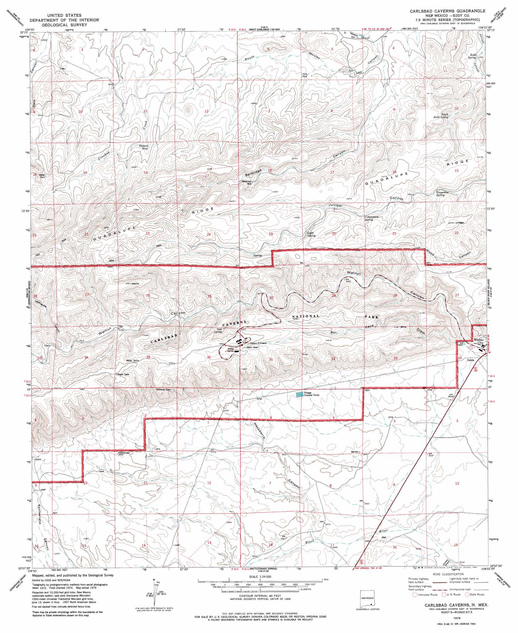
USGS Topo Quad 32104b4 - 1:24,000 scale
| Topo Map Name: | Carlsbad Caverns |
| USGS Topo Quad ID: | 32104b4 |
| Print Size: | ca. 21 1/4" wide x 27" high |
| Southeast Coordinates: | 32.125° N latitude / 104.375° W longitude |
| Map Center Coordinates: | 32.1875° N latitude / 104.4375° W longitude |
| U.S. State: | NM |
| Filename: | o32104b4.jpg |
| Download Map JPG Image: | Carlsbad Caverns topo map 1:24,000 scale |
| Map Type: | Topographic |
| Topo Series: | 7.5´ |
| Map Scale: | 1:24,000 |
| Source of Map Images: | United States Geological Survey (USGS) |
| Alternate Map Versions: |
Carlsbad Caverns NM 1979, updated 1979 Download PDF Buy paper map Carlsbad Caverns NM 1979, updated 1979 Download PDF Buy paper map Carlsbad Caverns NM 2010 Download PDF Buy paper map Carlsbad Caverns NM 2013 Download PDF Buy paper map Carlsbad Caverns NM 2017 Download PDF Buy paper map |
1:24,000 Topo Quads surrounding Carlsbad Caverns
Cawley Draw |
Martha Creek |
Azotea Peak |
Carlsbad West |
Carlsbad East |
Red Bluff Draw |
Bandanna Point |
Carnero Peak |
Kitchen Cove |
Otis |
Queen |
Serpentine Bends |
Carlsbad Caverns |
Black River Village |
Bond Draw |
Gunsight Canyon |
Grapevine Draw |
Rattlesnake Spring |
Jumping Spring |
Cottonwood Hills |
Independence Spring |
South Rector Canyon |
Alligator Draw |
Outlaw Spring |
Owl Hills |
> Back to 32104a1 at 1:100,000 scale
> Back to 32104a1 at 1:250,000 scale
> Back to U.S. Topo Maps home
Carlsbad Caverns topo map: Gazetteer
Carlsbad Caverns: Parks
Carlsbad Caverns National Park elevation 1344m 4409′Carlsbad Caverns: Populated Places
Whites City elevation 1116m 3661′Carlsbad Caverns: Post Offices
Whites City Post Office elevation 1116m 3661′Carlsbad Caverns: Reservoirs
Lowe Tank elevation 1175m 3854′Stone Tank (historical) elevation 1195m 3920′
Carlsbad Caverns: Springs
Cottonwood Spring elevation 1256m 4120′Grapevine Spring elevation 1222m 4009′
Light Spring elevation 1296m 4251′
Mosley Springs elevation 1146m 3759′
North Mosley Spring elevation 1148m 3766′
Oak Spring elevation 1316m 4317′
Robb Spring elevation 1131m 3710′
South Robb Spring elevation 1175m 3854′
Stetson Seep elevation 1277m 4189′
Carlsbad Caverns: Valleys
Baldridge Canyon elevation 1152m 3779′Bat Cave Draw elevation 1114m 3654′
Chosa Draw elevation 1049m 3441′
Hackberry Canyon elevation 1069m 3507′
Lechuguilla Canyon elevation 1319m 4327′
Lechuguilla Canyon elevation 1202m 3943′
North Mosley Canyon elevation 1144m 3753′
South Mosley Canyon elevation 1144m 3753′
Carlsbad Caverns: Wells
10312 Water Well elevation 1057m 3467′Baldridge Well elevation 1257m 4124′
Carlsbad Caverns digital topo map on disk
Buy this Carlsbad Caverns topo map showing relief, roads, GPS coordinates and other geographical features, as a high-resolution digital map file on DVD: