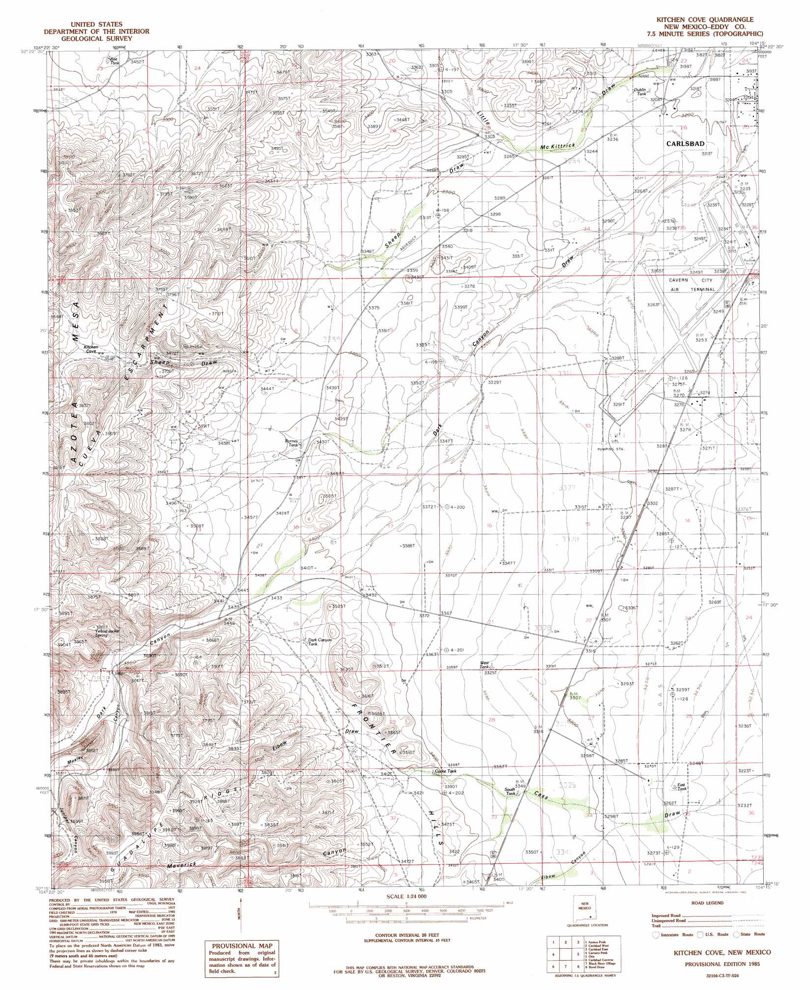
Kitchen Cove Topo Map New Mexico
To zoom in, hover over the map of Kitchen Cove
USGS Topo Quad 32104c3 - 1:24,000 scale
| Topo Map Name: | Kitchen Cove |
| USGS Topo Quad ID: | 32104c3 |
| Print Size: | ca. 21 1/4" wide x 27" high |
| Southeast Coordinates: | 32.25° N latitude / 104.25° W longitude |
| Map Center Coordinates: | 32.3125° N latitude / 104.3125° W longitude |
| U.S. State: | NM |
| Filename: | o32104c3.jpg |
| Download Map JPG Image: | Kitchen Cove topo map 1:24,000 scale |
| Map Type: | Topographic |
| Topo Series: | 7.5´ |
| Map Scale: | 1:24,000 |
| Source of Map Images: | United States Geological Survey (USGS) |
| Alternate Map Versions: |
Kitchen Cove NM 1985, updated 1985 Download PDF Buy paper map Kitchen Cove NM 2010 Download PDF Buy paper map Kitchen Cove NM 2013 Download PDF Buy paper map Kitchen Cove NM 2017 Download PDF Buy paper map |
1:24,000 Topo Quads surrounding Kitchen Cove
Foster Ranch |
Seven Rivers |
Lake Mcmillan South |
Angel Draw |
Illinois Camp Se |
Martha Creek |
Azotea Peak |
Carlsbad West |
Carlsbad East |
Indian Flats |
Bandanna Point |
Carnero Peak |
Kitchen Cove |
Otis |
Loving |
Serpentine Bends |
Carlsbad Caverns |
Black River Village |
Bond Draw |
Malaga |
Grapevine Draw |
Rattlesnake Spring |
Jumping Spring |
Cottonwood Hills |
Red Bluff |
> Back to 32104a1 at 1:100,000 scale
> Back to 32104a1 at 1:250,000 scale
> Back to U.S. Topo Maps home
Kitchen Cove topo map: Gazetteer
Kitchen Cove: Airports
Cavern City Air Terminal elevation 992m 3254′Kitchen Cove: Areas
Kitchen Cove elevation 1085m 3559′Kitchen Cove: Mines
Carlsbad Pit elevation 987m 3238′Eddy County Pits elevation 977m 3205′
Kitchen Cove: Ranges
Frontier Hills elevation 1099m 3605′Kitchen Cove: Reservoirs
Byrnes Tank elevation 1036m 3398′Cocke Tank elevation 1031m 3382′
Dark Canyon Tank elevation 1053m 3454′
Dublin Tank elevation 976m 3202′
East Tank elevation 991m 3251′
Kee Tank elevation 1054m 3458′
South Tank elevation 1020m 3346′
West Tank elevation 1014m 3326′
Kitchen Cove: Ridges
Cueva Escarpment elevation 1187m 3894′Kitchen Cove: Springs
Yellow Jacket Spring elevation 1114m 3654′Kitchen Cove: Valleys
Dark Canyon elevation 1048m 3438′Elbow Canyon elevation 1002m 3287′
Elbow Draw elevation 1035m 3395′
Juniper Canyon elevation 1096m 3595′
Little McKittrick Draw elevation 970m 3182′
Maverick Canyon elevation 1064m 3490′
Mosley Canyon elevation 1061m 3480′
Sheep Draw elevation 994m 3261′
Kitchen Cove: Wells
10215 Water Well elevation 974m 3195′10218 Water Well elevation 994m 3261′
10220 Water Well elevation 984m 3228′
10221 Water Well elevation 983m 3225′
10257 Water Well elevation 1176m 3858′
10258 Water Well elevation 1064m 3490′
10260 Water Well elevation 1002m 3287′
10261 Water Well elevation 1040m 3412′
10262 Water Well elevation 1026m 3366′
10264 Water Well elevation 1047m 3435′
10267 Water Well elevation 1072m 3517′
10268 Water Well elevation 994m 3261′
10411 Water Well elevation 984m 3228′
10416 Water Well elevation 1063m 3487′
Dublin Well elevation 996m 3267′
Kitchen Cove digital topo map on disk
Buy this Kitchen Cove topo map showing relief, roads, GPS coordinates and other geographical features, as a high-resolution digital map file on DVD: