Ares Peak Topo Map New Mexico
To zoom in, hover over the map of Ares Peak
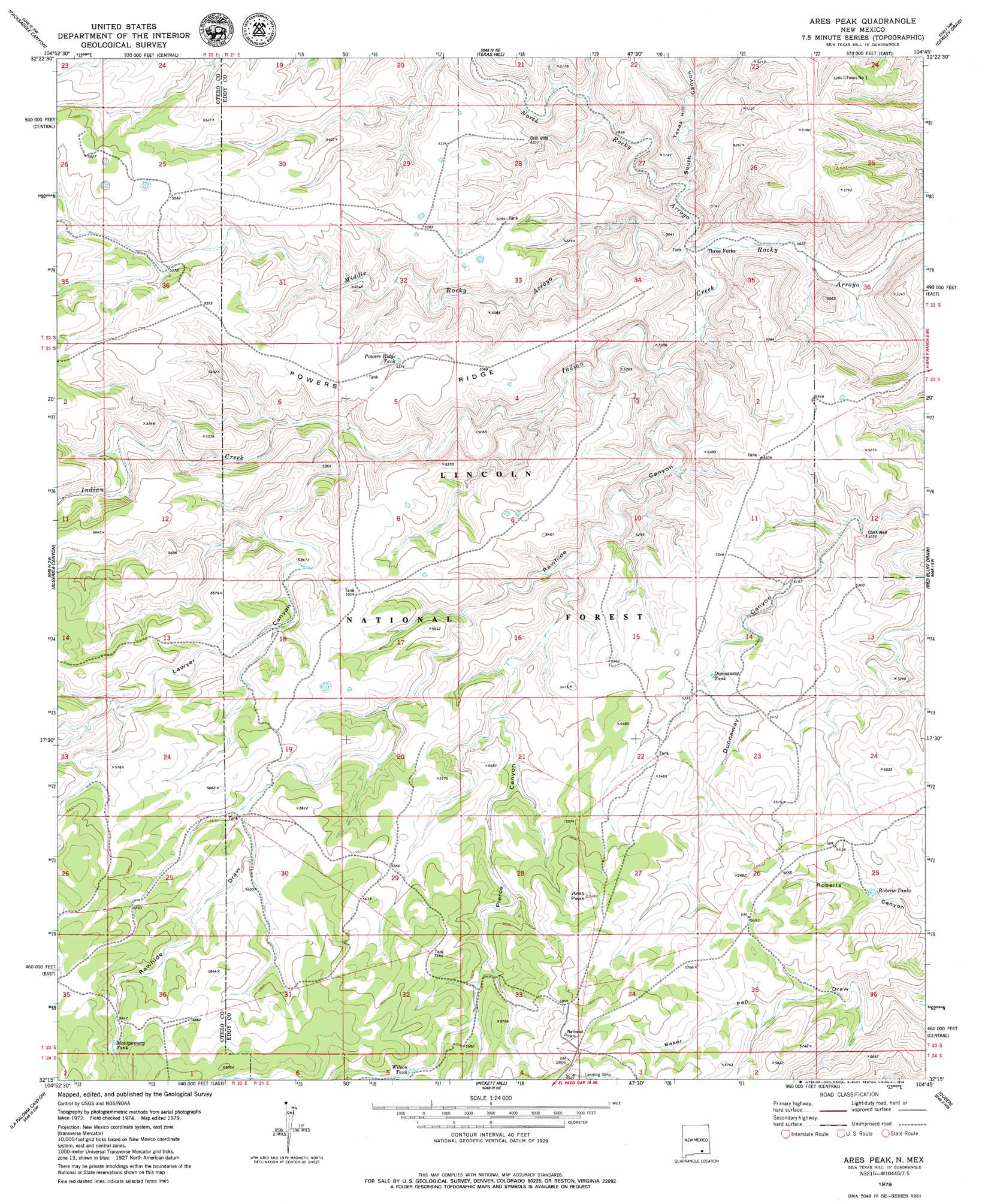
USGS Topo Quad 32104c7 - 1:24,000 scale
| Topo Map Name: | Ares Peak |
| USGS Topo Quad ID: | 32104c7 |
| Print Size: | ca. 21 1/4" wide x 27" high |
| Southeast Coordinates: | 32.25° N latitude / 104.75° W longitude |
| Map Center Coordinates: | 32.3125° N latitude / 104.8125° W longitude |
| U.S. State: | NM |
| Filename: | o32104c7.jpg |
| Download Map JPG Image: | Ares Peak topo map 1:24,000 scale |
| Map Type: | Topographic |
| Topo Series: | 7.5´ |
| Map Scale: | 1:24,000 |
| Source of Map Images: | United States Geological Survey (USGS) |
| Alternate Map Versions: |
Ares Peak NM 2001, updated 2003 Download PDF Buy paper map Ares Peak NM 2011 Download PDF Buy paper map Ares Peak NM 2013 Download PDF Buy paper map Ares Peak NM 2017 Download PDF Buy paper map |
| FStopo: | US Forest Service topo Ares Peak is available: Download FStopo PDF Download FStopo TIF |
1:24,000 Topo Quads surrounding Ares Peak
Bullis Spring Ranch |
South Taylor Tank |
Strychnine Draw |
Box Canyon Ranch |
Foster Ranch |
Panama Ranch |
Packsaddle Canyon |
Texas Hill |
Cawley Draw |
Martha Creek |
Gowdy Ranch |
Algerita Canyon |
Ares Peak |
Red Bluff Draw |
Bandanna Point |
Sheep Draw |
La Paloma Canyon |
Pickett Hill |
Queen |
Serpentine Bends |
Cienega School |
Panther Canyon |
El Paso Gap |
Gunsight Canyon |
Grapevine Draw |
> Back to 32104a1 at 1:100,000 scale
> Back to 32104a1 at 1:250,000 scale
> Back to U.S. Topo Maps home
Ares Peak topo map: Gazetteer
Ares Peak: Parks
Guadalupe Mountains Historical Marker elevation 1647m 5403′Ares Peak: Populated Places
Three Forks elevation 1427m 4681′Ares Peak: Reservoirs
Acrey Water Storage Tank elevation 1653m 5423′Black Water Storage Tank elevation 1656m 5433′
B-Storage Tank elevation 1626m 5334′
Dunnaway Tank elevation 1617m 5305′
Foster Water Storage Tank elevation 1728m 5669′
Heard Storage Tank elevation 1616m 5301′
Hearn elevation 1630m 5347′
Joyce Water Storage Tank elevation 1780m 5839′
Lawyer Dirt Tank elevation 1625m 5331′
Montgomery Tank elevation 1782m 5846′
Montgomery Water Storage Tank elevation 1792m 5879′
Powers Ridge Tank elevation 1632m 5354′
Rawhide Water Storage Tank elevation 1693m 5554′
Roberts Tanks elevation 1658m 5439′
Sandia elevation 1675m 5495′
Wilson Tank elevation 1735m 5692′
Ares Peak: Ridges
Powers Ridge elevation 1651m 5416′Ares Peak: Streams
Indian Creek elevation 1414m 4639′Middle Rocky Arroyo elevation 1430m 4691′
North Rocky Arroyo elevation 1417m 4648′
Ares Peak: Summits
Ares Peak elevation 1757m 5764′Ares Peak: Valleys
Lawyer Canyon elevation 1571m 5154′North Rocky Canyon elevation 1430m 4691′
Pierce Canyon elevation 1559m 5114′
Rawhide Canyon elevation 1459m 4786′
Rawhide Draw elevation 1691m 5547′
South Texas Hill Canyon elevation 1446m 4744′
Ares Peak: Wells
Clark Well elevation 1544m 5065′Ares Peak digital topo map on disk
Buy this Ares Peak topo map showing relief, roads, GPS coordinates and other geographical features, as a high-resolution digital map file on DVD: