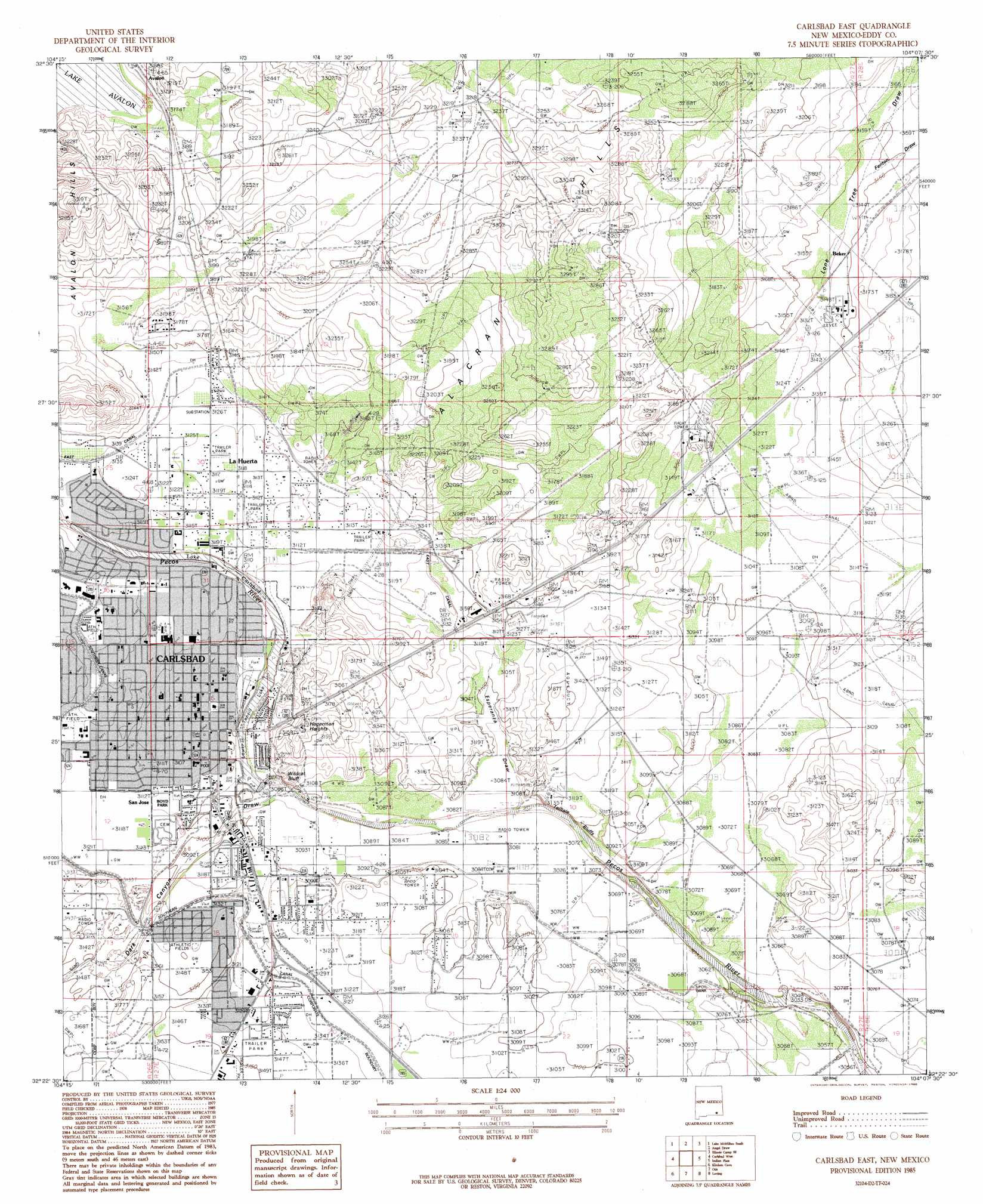
Carlsbad East Topo Map New Mexico
To zoom in, hover over the map of Carlsbad East
USGS Topo Quad 32104d2 - 1:24,000 scale
| Topo Map Name: | Carlsbad East |
| USGS Topo Quad ID: | 32104d2 |
| Print Size: | ca. 21 1/4" wide x 27" high |
| Southeast Coordinates: | 32.375° N latitude / 104.125° W longitude |
| Map Center Coordinates: | 32.4375° N latitude / 104.1875° W longitude |
| U.S. State: | NM |
| Filename: | o32104d2.jpg |
| Download Map JPG Image: | Carlsbad East topo map 1:24,000 scale |
| Map Type: | Topographic |
| Topo Series: | 7.5´ |
| Map Scale: | 1:24,000 |
| Source of Map Images: | United States Geological Survey (USGS) |
| Alternate Map Versions: |
Carlsbad East NM 1985, updated 1985 Download PDF Buy paper map Carlsbad East NM 2010 Download PDF Buy paper map Carlsbad East NM 2013 Download PDF Buy paper map Carlsbad East NM 2017 Download PDF Buy paper map |
1:24,000 Topo Quads surrounding Carlsbad East
Dayton |
Lake Mcmillan North |
Illinois Camp |
Illinois Camp Ne |
Hackberry Lake |
Seven Rivers |
Lake Mcmillan South |
Angel Draw |
Illinois Camp Se |
Tower Hill North |
Azotea Peak |
Carlsbad West |
Carlsbad East |
Indian Flats |
Tower Hill South |
Carnero Peak |
Kitchen Cove |
Otis |
Loving |
Remuda Basin |
Carlsbad Caverns |
Black River Village |
Bond Draw |
Malaga |
Pierce Canyon |
> Back to 32104a1 at 1:100,000 scale
> Back to 32104a1 at 1:250,000 scale
> Back to U.S. Topo Maps home
Carlsbad East topo map: Gazetteer
Carlsbad East: Canals
East Canal elevation 953m 3126′Carlsbad East: Cliffs
Telltale Bluffs elevation 952m 3123′Wildcat Bluff elevation 956m 3136′
Carlsbad East: Dams
Lower Transill Dam elevation 943m 3093′Six Mile Dam elevation 930m 3051′
Tansill Dam elevation 942m 3090′
Carlsbad East: Lakes
Lower Tonsill Lake elevation 942m 3090′Willow lake elevation 959m 3146′
Carlsbad East: Mines
Constructors Pit Incorporated Crusher elevation 950m 3116′New Mexico Salt Company elevation 960m 3149′
Rose Pit elevation 953m 3126′
Townsite Salt elevation 946m 3103′
Carlsbad East: Parks
Boyd Park elevation 948m 3110′Carlsbad Historical Marker elevation 945m 3100′
Carlsbad East: Populated Places
Avalon elevation 970m 3182′Carlsbad elevation 945m 3100′
Hagerman Heights elevation 947m 3106′
La Huerta elevation 951m 3120′
San Jose elevation 948m 3110′
Carlsbad East: Post Offices
Carlsbad Post Office elevation 956m 3136′Carlsbad East: Ranges
Alacran Hills elevation 1009m 3310′Avalon Hills elevation 969m 3179′
Carlsbad East: Reservoirs
Lower Transill Reservoir elevation 943m 3093′Carlsbad East: Springs
Carlsbad Spring Number 3 elevation 949m 3113′Carlsbad Spring Number 5 elevation 947m 3106′
Carlsbad East: Valleys
Dark Canyon Draw elevation 942m 3090′Esperanza Draw elevation 941m 3087′
Fenton Draw elevation 961m 3152′
Lone Tree Draw elevation 953m 3126′
Carlsbad East: Wells
10191 Water Well elevation 960m 3149′10192 Water Well elevation 952m 3123′
10194 Water Well elevation 951m 3120′
10196 Water Well elevation 956m 3136′
10197 Water Well elevation 951m 3120′
10198 Water Well elevation 953m 3126′
10199 Water Well elevation 950m 3116′
10200 Water Well elevation 953m 3126′
10201 Water Well elevation 950m 3116′
10202 Water Well elevation 949m 3113′
10204 Water Well elevation 951m 3120′
10205 Water Well elevation 951m 3120′
10206 Water Well elevation 951m 3120′
10207 Water Well elevation 971m 3185′
10216 Water Well elevation 963m 3159′
10224 Water Well elevation 944m 3097′
10225 Water Well elevation 943m 3093′
10226 Water Well elevation 944m 3097′
10227 Water Well elevation 955m 3133′
10228 Water Well elevation 939m 3080′
10229 Water Well elevation 946m 3103′
10230 Water Well elevation 938m 3077′
10231 Water Well elevation 948m 3110′
10232 Water Well elevation 955m 3133′
10234 Water Well elevation 953m 3126′
10235 Water Well elevation 959m 3146′
10238 Water Well elevation 945m 3100′
10410 Water Well elevation 951m 3120′
10412 Water Well elevation 948m 3110′
Carlsbad East digital topo map on disk
Buy this Carlsbad East topo map showing relief, roads, GPS coordinates and other geographical features, as a high-resolution digital map file on DVD: