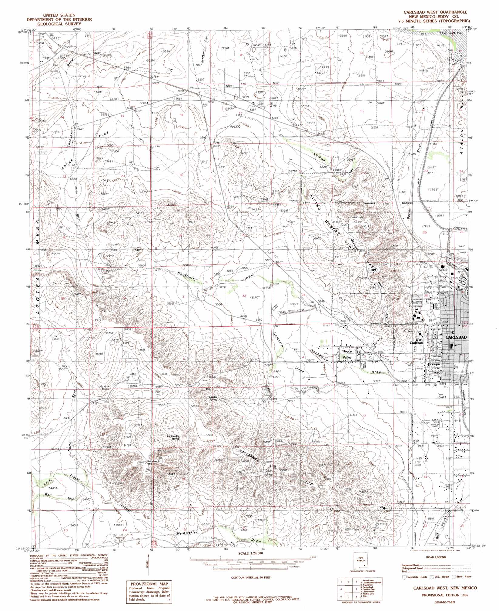
Carlsbad West Topo Map New Mexico
To zoom in, hover over the map of Carlsbad West
USGS Topo Quad 32104d3 - 1:24,000 scale
| Topo Map Name: | Carlsbad West |
| USGS Topo Quad ID: | 32104d3 |
| Print Size: | ca. 21 1/4" wide x 27" high |
| Southeast Coordinates: | 32.375° N latitude / 104.25° W longitude |
| Map Center Coordinates: | 32.4375° N latitude / 104.3125° W longitude |
| U.S. State: | NM |
| Filename: | o32104d3.jpg |
| Download Map JPG Image: | Carlsbad West topo map 1:24,000 scale |
| Map Type: | Topographic |
| Topo Series: | 7.5´ |
| Map Scale: | 1:24,000 |
| Source of Map Images: | United States Geological Survey (USGS) |
| Alternate Map Versions: |
Carlsbad West NM 1985, updated 1985 Download PDF Buy paper map Carlsbad West NM 1985, updated 1985 Download PDF Buy paper map Carlsbad West NM 2010 Download PDF Buy paper map Carlsbad West NM 2013 Download PDF Buy paper map Carlsbad West NM 2017 Download PDF Buy paper map |
1:24,000 Topo Quads surrounding Carlsbad West
Parish Ranch |
Dayton |
Lake Mcmillan North |
Illinois Camp |
Illinois Camp Ne |
Foster Ranch |
Seven Rivers |
Lake Mcmillan South |
Angel Draw |
Illinois Camp Se |
Martha Creek |
Azotea Peak |
Carlsbad West |
Carlsbad East |
Indian Flats |
Bandanna Point |
Carnero Peak |
Kitchen Cove |
Otis |
Loving |
Serpentine Bends |
Carlsbad Caverns |
Black River Village |
Bond Draw |
Malaga |
> Back to 32104a1 at 1:100,000 scale
> Back to 32104a1 at 1:250,000 scale
> Back to U.S. Topo Maps home
Carlsbad West topo map: Gazetteer
Carlsbad West: Areas
Hackberry Slope elevation 984m 3228′Happy Valley elevation 970m 3182′
Carlsbad West: Canals
Main Canal elevation 962m 3156′Southern Canal elevation 957m 3139′
Carlsbad West: Dams
Avalon Dam elevation 959m 3146′Hackberry Draw Site Number One Dam elevation 986m 3234′
Hackberry Draw Watershed Site Number Two Dam elevation 1010m 3313′
Carlsbad West: Flats
Adobe Flat elevation 1006m 3300′Carlsbad West: Mines
Eddy County Pits elevation 958m 3143′Golden Eagle Mine elevation 1024m 3359′
Lone Eagle elevation 1025m 3362′
Rose Gravel Co Plant elevation 955m 3133′
Carlsbad West: Parks
Carlsbad National Wildlife Refuge elevation 974m 3195′Living Desert State Park elevation 1047m 3435′
Carlsbad West: Populated Places
Four Forks elevation 1040m 3412′West Carlsbad elevation 960m 3149′
Carlsbad West: Ranges
Hackberry Hills elevation 1102m 3615′Ocotillo Hills elevation 1068m 3503′
Carlsbad West: Reservoirs
Lake Avalon elevation 959m 3146′Carlsbad West: Springs
Carlsbad Spring Number 16 elevation 963m 3159′Lancaster Spring elevation 1043m 3421′
Lassiter Spring elevation 1042m 3418′
Mc Kitric Spring elevation 1069m 3507′
Mc Kitric Spring elevation 1074m 3523′
McGruder Spring elevation 1072m 3517′
Carlsbad West: Summits
McGruder Hill elevation 1155m 3789′Carlsbad West: Valleys
Adobe Draw elevation 1007m 3303′Calabaza Draw elevation 961m 3152′
Hackberry Draw elevation 961m 3152′
North Fork Little McKittrick Draw elevation 1039m 3408′
West Fork Little McKittrick Draw elevation 1039m 3408′
Carlsbad West: Wells
10189 Water Well elevation 959m 3146′10190 Water Well elevation 959m 3146′
10208 Water Well elevation 963m 3159′
10209 Water Well elevation 969m 3179′
10210 Water Well elevation 962m 3156′
10211 Water Well elevation 957m 3139′
10212 Water Well elevation 958m 3143′
10213 Water Well elevation 968m 3175′
10214 Water Well elevation 987m 3238′
Allen Well elevation 1038m 3405′
Dark Canyon Wells elevation 967m 3172′
Leck Well elevation 995m 3264′
Thayer Wells elevation 1041m 3415′
Carlsbad West digital topo map on disk
Buy this Carlsbad West topo map showing relief, roads, GPS coordinates and other geographical features, as a high-resolution digital map file on DVD: