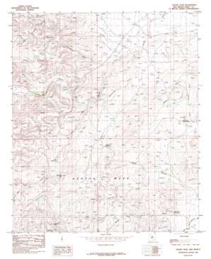
Azotea Peak Topo Map New Mexico
To zoom in, hover over the map of Azotea Peak
USGS Topo Quad 32104d4 - 1:24,000 scale
| Topo Map Name: | Azotea Peak |
| USGS Topo Quad ID: | 32104d4 |
| Print Size: | ca. 21 1/4" wide x 27" high |
| Southeast Coordinates: | 32.375° N latitude / 104.375° W longitude |
| Map Center Coordinates: | 32.4375° N latitude / 104.4375° W longitude |
| U.S. State: | NM |
| Filename: | o32104d4.jpg |
| Download Map JPG Image: | Azotea Peak topo map 1:24,000 scale |
| Map Type: | Topographic |
| Topo Series: | 7.5´ |
| Map Scale: | 1:24,000 |
| Source of Map Images: | United States Geological Survey (USGS) |
| Alternate Map Versions: |
Azotea Peak NM 1985, updated 1985 Download PDF Buy paper map Azotea Peak NM 2010 Download PDF Buy paper map Azotea Peak NM 2013 Download PDF Buy paper map Azotea Peak NM 2017 Download PDF Buy paper map |
1:24,000 Topo Quads surrounding Azotea Peak
> Back to 32104a1 at 1:100,000 scale
> Back to 32104a1 at 1:250,000 scale
> Back to U.S. Topo Maps home
Azotea Peak topo map: Gazetteer
Azotea Peak: Dams
Spencer Dam elevation 1040m 3412′Azotea Peak: Mines
Lepee Claims elevation 1192m 3910′Little Walt Canyon elevation 1194m 3917′
Rocky Arroyo elevation 1118m 3667′
Azotea Peak: Populated Places
Barber Crossing elevation 1030m 3379′Azotea Peak: Ranges
Seven Rivers Hills elevation 1173m 3848′Walt Canyon Hills elevation 1252m 4107′
Azotea Peak: Reservoirs
Boy D S Waterhole elevation 1111m 3645′Middle Fork Waterhole elevation 1087m 3566′
Rounds Waterhole elevation 1133m 3717′
Azotea Peak: Springs
Indian Big Spring elevation 1098m 3602′Little Walt Spring elevation 1180m 3871′
Walt Spring elevation 1181m 3874′
Azotea Peak: Summits
Azotea Peak elevation 1267m 4156′McKittrick Hill elevation 1309m 4294′
Nagooltee Peak elevation 1270m 4166′
Round Mountain elevation 1089m 3572′
Round Mountain elevation 1076m 3530′
Azotea Peak: Valleys
Boyds Canyon elevation 1059m 3474′Catclaw Draw elevation 1009m 3310′
Deadman Draw elevation 1035m 3395′
J Staple Canyon elevation 1084m 3556′
Little Walt Canyon elevation 1053m 3454′
Middle Fork Little McKittrick Draw elevation 1061m 3480′
Rain Spring Draw elevation 1079m 3540′
Righthand Canyon elevation 1131m 3710′
Rock Waterhole Canyon elevation 1201m 3940′
Schoolhouse Canyon elevation 1054m 3458′
Shafer Canyon elevation 1079m 3540′
South Spencer Draw elevation 1032m 3385′
Toms Canyon elevation 1190m 3904′
Walt Canyon elevation 1072m 3517′
Waterhole Draw elevation 1031m 3382′
Azotea Peak: Wells
06731 Water Well elevation 1134m 3720′06732 Water Well elevation 1084m 3556′
06733 Water Well elevation 1083m 3553′
06734 Water Well elevation 1111m 3645′
06735 Water Well elevation 1071m 3513′
06736 Water Well elevation 1123m 3684′
06740 Water Well elevation 1020m 3346′
06741 Water Well elevation 1020m 3346′
06742 Water Well elevation 1020m 3346′
06743 Water Well elevation 1022m 3353′
06744 Water Well elevation 1043m 3421′
06745 Water Well elevation 1048m 3438′
06746 Water Well elevation 1062m 3484′
06748 Water Well elevation 1068m 3503′
20028 Water Well elevation 1021m 3349′
20031 Water Well elevation 1048m 3438′
20033 Water Well elevation 1071m 3513′
20034 Water Well elevation 1067m 3500′
20143 Water Well elevation 1192m 3910′
20150 Water Well elevation 1092m 3582′
20151 Water Well elevation 1075m 3526′
20153 Water Well elevation 1139m 3736′
20154 Water Well elevation 1139m 3736′
Azotea Peak digital topo map on disk
Buy this Azotea Peak topo map showing relief, roads, GPS coordinates and other geographical features, as a high-resolution digital map file on DVD:


