Texas Hill Topo Map New Mexico
To zoom in, hover over the map of Texas Hill
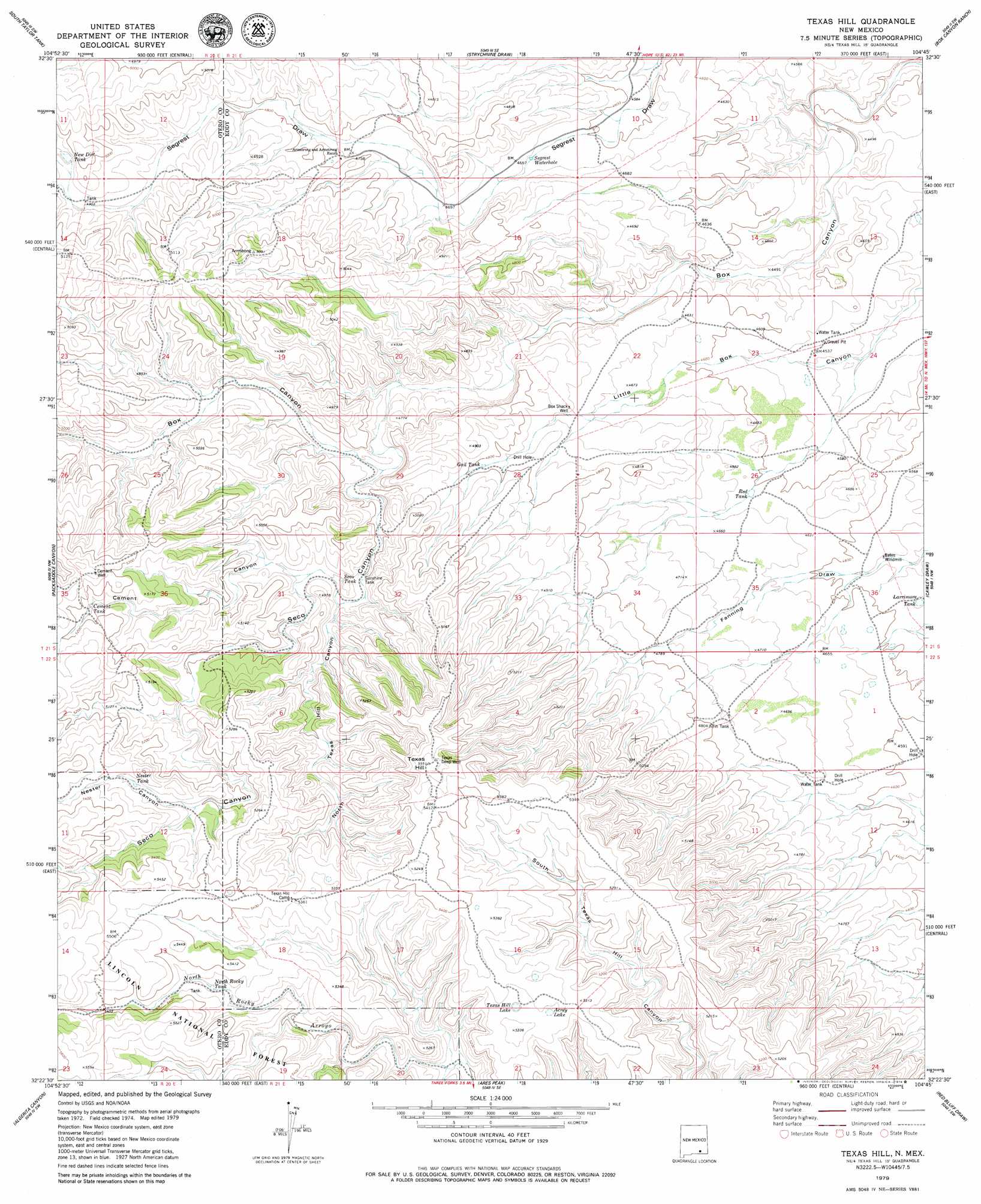
USGS Topo Quad 32104d7 - 1:24,000 scale
| Topo Map Name: | Texas Hill |
| USGS Topo Quad ID: | 32104d7 |
| Print Size: | ca. 21 1/4" wide x 27" high |
| Southeast Coordinates: | 32.375° N latitude / 104.75° W longitude |
| Map Center Coordinates: | 32.4375° N latitude / 104.8125° W longitude |
| U.S. State: | NM |
| Filename: | o32104d7.jpg |
| Download Map JPG Image: | Texas Hill topo map 1:24,000 scale |
| Map Type: | Topographic |
| Topo Series: | 7.5´ |
| Map Scale: | 1:24,000 |
| Source of Map Images: | United States Geological Survey (USGS) |
| Alternate Map Versions: |
Texas Hill NM 2001, updated 2003 Download PDF Buy paper map Texas Hill NM 2011 Download PDF Buy paper map Texas Hill NM 2013 Download PDF Buy paper map Texas Hill NM 2017 Download PDF Buy paper map |
| FStopo: | US Forest Service topo Texas Hill is available: Download FStopo PDF Download FStopo TIF |
1:24,000 Topo Quads surrounding Texas Hill
Lewis Peak Ne |
Encino Draw |
Holt Tank |
Antelope Sink |
Parish Ranch |
Bullis Spring Ranch |
South Taylor Tank |
Strychnine Draw |
Box Canyon Ranch |
Foster Ranch |
Panama Ranch |
Packsaddle Canyon |
Texas Hill |
Cawley Draw |
Martha Creek |
Gowdy Ranch |
Algerita Canyon |
Ares Peak |
Red Bluff Draw |
Bandanna Point |
Sheep Draw |
La Paloma Canyon |
Pickett Hill |
Queen |
Serpentine Bends |
> Back to 32104a1 at 1:100,000 scale
> Back to 32104a1 at 1:250,000 scale
> Back to U.S. Topo Maps home
Texas Hill topo map: Gazetteer
Texas Hill: Lakes
Acrey Lake elevation 1620m 5314′Texas Hill Lake elevation 1609m 5278′
Texas Hill: Reservoirs
Boulder Tank elevation 1439m 4721′Cement Tank elevation 1573m 5160′
Fanning Tank (historical) elevation 1421m 4662′
Gail Tank elevation 1458m 4783′
Howell Tank (historical) elevation 1499m 4917′
Larrimore Tank elevation 1391m 4563′
McGonigle Tanks elevation 1495m 4904′
Nester Tank elevation 1607m 5272′
New Dirt Tank elevation 1500m 4921′
New Dirt Tank elevation 1500m 4921′
North Rocky Tank elevation 1615m 5298′
Red Tank elevation 1404m 4606′
Seco Tank elevation 1487m 4878′
Segrest Waterhole elevation 1411m 4629′
Sunshine Tank elevation 1472m 4829′
Tin Tank elevation 1464m 4803′
Texas Hill: Springs
Boulder Waterhole (historical) elevation 1429m 4688′Texas Hill: Summits
Texas Hill elevation 1689m 5541′Texas Hill: Valleys
Cement Canyon elevation 1485m 4872′Nester Canyon elevation 1593m 5226′
North Texas Hill Canyon elevation 1472m 4829′
Seco Canyon elevation 1437m 4714′
Texas Hill digital topo map on disk
Buy this Texas Hill topo map showing relief, roads, GPS coordinates and other geographical features, as a high-resolution digital map file on DVD: