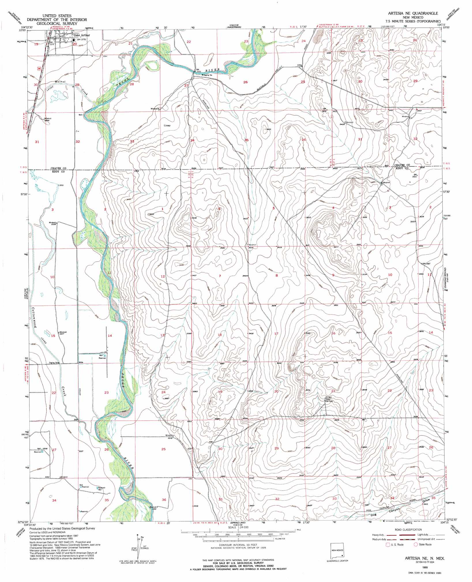
Artesia Ne Topo Map New Mexico
To zoom in, hover over the map of Artesia Ne
USGS Topo Quad 32104h3 - 1:24,000 scale
| Topo Map Name: | Artesia Ne |
| USGS Topo Quad ID: | 32104h3 |
| Print Size: | ca. 21 1/4" wide x 27" high |
| Southeast Coordinates: | 32.875° N latitude / 104.25° W longitude |
| Map Center Coordinates: | 32.9375° N latitude / 104.3125° W longitude |
| U.S. State: | NM |
| Filename: | o32104h3.jpg |
| Download Map JPG Image: | Artesia Ne topo map 1:24,000 scale |
| Map Type: | Topographic |
| Topo Series: | 7.5´ |
| Map Scale: | 1:24,000 |
| Source of Map Images: | United States Geological Survey (USGS) |
| Alternate Map Versions: |
Artesia NE NM 1955, updated 1956 Download PDF Buy paper map Artesia NE NM 1955, updated 1972 Download PDF Buy paper map Artesia NE NM 1955, updated 1993 Download PDF Buy paper map Artesia NE NM 2010 Download PDF Buy paper map Artesia NE NM 2013 Download PDF Buy paper map Artesia NE NM 2017 Download PDF Buy paper map |
1:24,000 Topo Quads surrounding Artesia Ne
Peters Lake |
Dexter West |
Dexter East |
Bar C Bar Ranch |
Conner Well |
Hackberry Ranch |
Hagerman Sw |
Hagerman |
Derrick Draw |
King Camp |
Hope Ne |
Espuela |
Artesia Ne |
Diamond Mound |
Basin Well |
Hope Se |
Artesia |
Spring Lake |
Red Lake |
Red Lake Se |
Parish Ranch |
Dayton |
Lake Mcmillan North |
Illinois Camp |
Illinois Camp Ne |
> Back to 32104e1 at 1:100,000 scale
> Back to 32104a1 at 1:250,000 scale
> Back to U.S. Topo Maps home
Artesia Ne topo map: Gazetteer
Artesia Ne: Populated Places
Lake Arthur elevation 1030m 3379′Artesia Ne: Post Offices
Lake Arthur Post Office elevation 1030m 3379′Artesia Ne: Streams
Cottonwood Creek elevation 1009m 3310′Walnut Creek elevation 1015m 3330′
Artesia Ne: Wells
05346 Water Well elevation 1030m 3379′05347 Water Well elevation 1024m 3359′
05348 Water Well elevation 1027m 3369′
05349 Water Well elevation 1025m 3362′
05350 Water Well elevation 1019m 3343′
05351 Water Well elevation 1016m 3333′
06124 Water Well elevation 1028m 3372′
06126 Water Well elevation 1020m 3346′
10348 Water Well elevation 1020m 3346′
10349 Water Well elevation 1022m 3353′
10354 Water Well elevation 1016m 3333′
10913 Water Well elevation 1016m 3333′
10914 Water Well elevation 1018m 3339′
10915 Water Well elevation 1019m 3343′
10917 Water Well elevation 1019m 3343′
10918 Water Well elevation 1023m 3356′
10919 Water Well elevation 1022m 3353′
12827 Water Well elevation 1019m 3343′
12885 Water Well elevation 1020m 3346′
12886 Water Well elevation 1021m 3349′
12887 Water Well elevation 1021m 3349′
13590 Water Well elevation 1027m 3369′
13593 Water Well elevation 1016m 3333′
Artesia Ne digital topo map on disk
Buy this Artesia Ne topo map showing relief, roads, GPS coordinates and other geographical features, as a high-resolution digital map file on DVD: