Alamo Mountain Topo Map New Mexico
To zoom in, hover over the map of Alamo Mountain
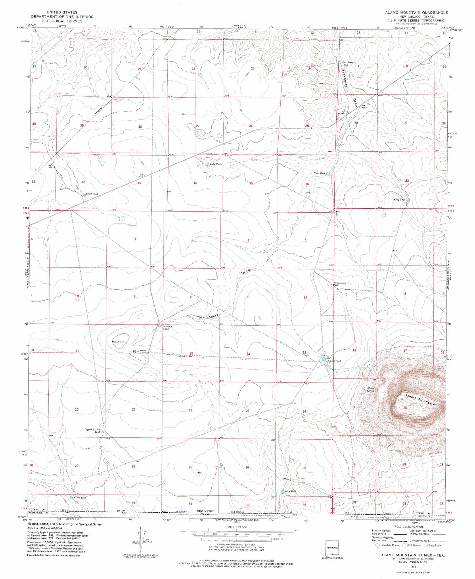
USGS Topo Quad 32105a6 - 1:24,000 scale
| Topo Map Name: | Alamo Mountain |
| USGS Topo Quad ID: | 32105a6 |
| Print Size: | ca. 21 1/4" wide x 27" high |
| Southeast Coordinates: | 32° N latitude / 105.625° W longitude |
| Map Center Coordinates: | 32.0625° N latitude / 105.6875° W longitude |
| U.S. States: | NM, TX |
| Filename: | o32105a6.jpg |
| Download Map JPG Image: | Alamo Mountain topo map 1:24,000 scale |
| Map Type: | Topographic |
| Topo Series: | 7.5´ |
| Map Scale: | 1:24,000 |
| Source of Map Images: | United States Geological Survey (USGS) |
| Alternate Map Versions: |
Alamo Mountain NM 1975, updated 1977 Download PDF Buy paper map Alamo Mountain NM 2010 Download PDF Buy paper map Alamo Mountain NM 2013 Download PDF Buy paper map Alamo Mountain NM 2017 Download PDF Buy paper map |
1:24,000 Topo Quads surrounding Alamo Mountain
Mack Tanks |
Otero Mesa South |
Stone Well |
Stockard Well |
Cleones Tank |
Owl Tank Canyon West |
Owl Tank Canyon East |
B T Ranch |
Alamo Mountain Ne |
Shiloh Hills |
Mountain Tank |
Alamo Mountain |
Alamo Mountain |
Cornudas Mountain |
Mcveigh Hills |
Cerro Alto Mountain |
Hobo Tank |
Big Heiser Tank |
Sixteen Mountains |
Cerro Diablo |
Phone Line Canyon |
Buckhorn Draw West |
Buckhorn Draw East |
Molesworth Mesa North |
Cornudas |
> Back to 32105a1 at 1:100,000 scale
> Back to 32104a1 at 1:250,000 scale
> Back to U.S. Topo Maps home
Alamo Mountain topo map: Gazetteer
Alamo Mountain: Reservoirs
Alamo Tank elevation 1553m 5095′Copper Bottom Tank elevation 1534m 5032′
Grief Tank elevation 1526m 5006′
Hackberry Tank elevation 1475m 4839′
Hood Tank elevation 1501m 4924′
King Tank elevation 1524m 5000′
Lake Tank elevation 1518m 4980′
Line Tank elevation 1516m 4973′
Mixen Tank elevation 1514m 4967′
Murphy Tank elevation 1564m 5131′
Alamo Mountain: Springs
Alamo Spring elevation 1669m 5475′Alamo Mountain: Summits
Alamo Mountain elevation 2031m 6663′Alamo Mountain: Wells
Grief Well elevation 1525m 5003′Partnership Well elevation 1551m 5088′
Alamo Mountain digital topo map on disk
Buy this Alamo Mountain topo map showing relief, roads, GPS coordinates and other geographical features, as a high-resolution digital map file on DVD: