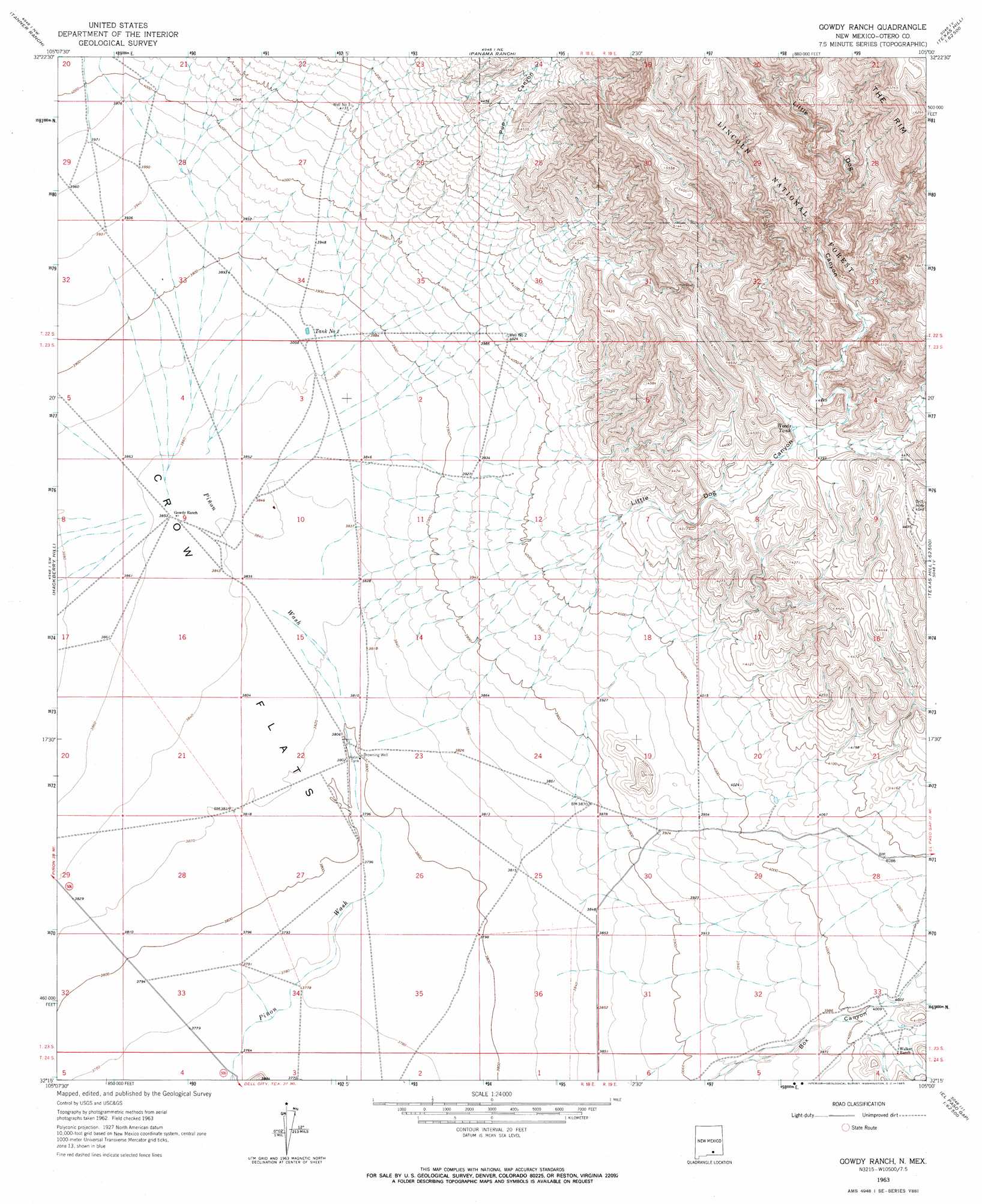
Gowdy Ranch Topo Map New Mexico
To zoom in, hover over the map of Gowdy Ranch
USGS Topo Quad 32105c1 - 1:24,000 scale
| Topo Map Name: | Gowdy Ranch |
| USGS Topo Quad ID: | 32105c1 |
| Print Size: | ca. 21 1/4" wide x 27" high |
| Southeast Coordinates: | 32.25° N latitude / 105° W longitude |
| Map Center Coordinates: | 32.3125° N latitude / 105.0625° W longitude |
| U.S. State: | NM |
| Filename: | o32105c1.jpg |
| Download Map JPG Image: | Gowdy Ranch topo map 1:24,000 scale |
| Map Type: | Topographic |
| Topo Series: | 7.5´ |
| Map Scale: | 1:24,000 |
| Source of Map Images: | United States Geological Survey (USGS) |
| Alternate Map Versions: |
Gowdy Ranch NM 1963, updated 1965 Download PDF Buy paper map Gowdy Ranch NM 2001, updated 2003 Download PDF Buy paper map Gowdy Ranch NM 2011 Download PDF Buy paper map Gowdy Ranch NM 2013 Download PDF Buy paper map Gowdy Ranch NM 2017 Download PDF Buy paper map |
| FStopo: | US Forest Service topo Gowdy Ranch is available: Download FStopo PDF Download FStopo TIF |
1:24,000 Topo Quads surrounding Gowdy Ranch
Cornucopia Canyon |
Pinon Ranch |
Bullis Spring Ranch |
South Taylor Tank |
Strychnine Draw |
Cornucopia Ranch |
Tanner Ranch |
Panama Ranch |
Packsaddle Canyon |
Texas Hill |
Cornucopia Ranch Se |
Hackberry Hill |
Gowdy Ranch |
Algerita Canyon |
Ares Peak |
Van Winkle Lake |
Lewis Canyon |
Sheep Draw |
La Paloma Canyon |
Pickett Hill |
Shiloh Hills Se |
Culp Draw |
Cienega School |
Panther Canyon |
El Paso Gap |
> Back to 32105a1 at 1:100,000 scale
> Back to 32104a1 at 1:250,000 scale
> Back to U.S. Topo Maps home
Gowdy Ranch topo map: Gazetteer
Gowdy Ranch: Reservoirs
Tank Number 2 elevation 1181m 3874′Woods Tank elevation 1326m 4350′
Gowdy Ranch: Valleys
Little Dog Canyon elevation 1165m 3822′Pup Canyon elevation 1177m 3861′
Woods Canyon elevation 1326m 4350′
Gowdy Ranch: Wells
Well Number Three elevation 1261m 4137′Well Number Two elevation 1227m 4025′
Gowdy Ranch digital topo map on disk
Buy this Gowdy Ranch topo map showing relief, roads, GPS coordinates and other geographical features, as a high-resolution digital map file on DVD: