Bear Spring Topo Map New Mexico
To zoom in, hover over the map of Bear Spring
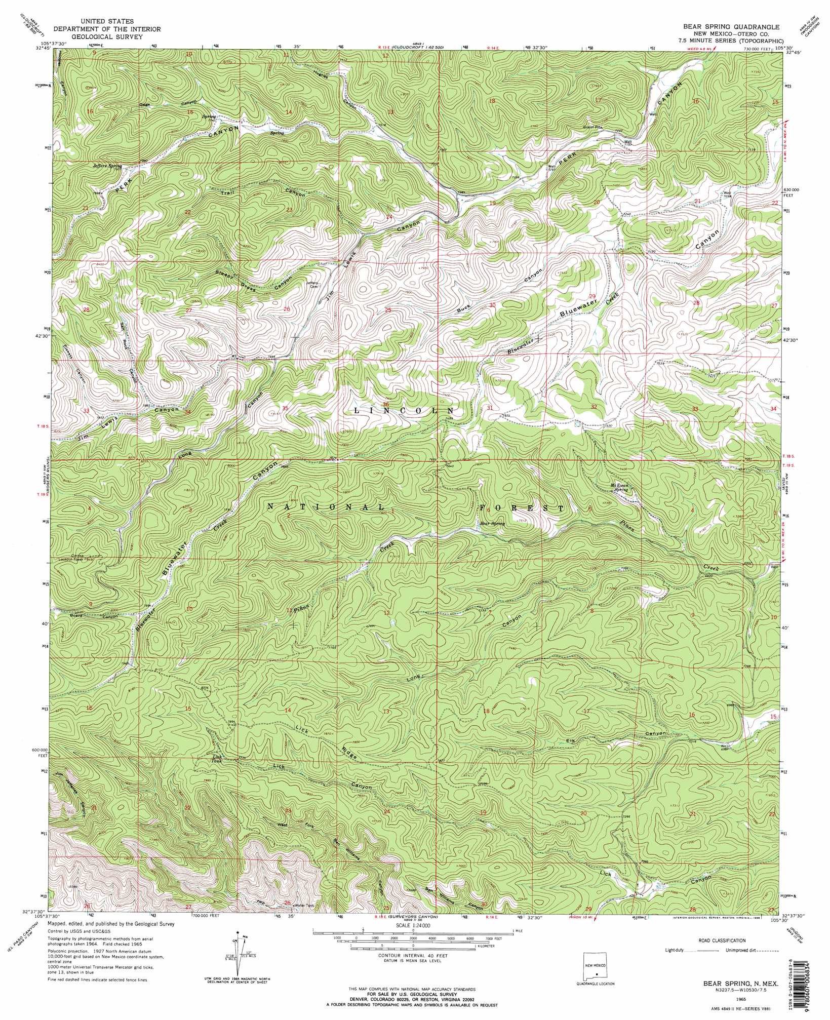
USGS Topo Quad 32105f5 - 1:24,000 scale
| Topo Map Name: | Bear Spring |
| USGS Topo Quad ID: | 32105f5 |
| Print Size: | ca. 21 1/4" wide x 27" high |
| Southeast Coordinates: | 32.625° N latitude / 105.5° W longitude |
| Map Center Coordinates: | 32.6875° N latitude / 105.5625° W longitude |
| U.S. State: | NM |
| Filename: | o32105f5.jpg |
| Download Map JPG Image: | Bear Spring topo map 1:24,000 scale |
| Map Type: | Topographic |
| Topo Series: | 7.5´ |
| Map Scale: | 1:24,000 |
| Source of Map Images: | United States Geological Survey (USGS) |
| Alternate Map Versions: |
Bear Spring NM 1965, updated 1968 Download PDF Buy paper map Bear Spring NM 1965, updated 1968 Download PDF Buy paper map Bear Spring NM 2004, updated 2006 Download PDF Buy paper map Bear Spring NM 2011 Download PDF Buy paper map Bear Spring NM 2013 Download PDF Buy paper map Bear Spring NM 2017 Download PDF Buy paper map |
| FStopo: | US Forest Service topo Bear Spring is available: Download FStopo PDF Download FStopo TIF |
1:24,000 Topo Quads surrounding Bear Spring
High Rolls |
Cloudcroft |
Harvey Ranch |
Mayhill |
Elk |
Sacramento Peak |
Bluff Springs |
Sacramento |
Woodson Canyon |
Robertson Canyon |
Bug Scuffle Canyon |
Rogers Ruins |
Bear Spring |
Avis |
Chimney Lake |
Culp Canyon |
El Paso Canyon |
Surveyors Canyon |
Pinon |
Cornucopia Canyon |
Otero Mesa North |
El Paso Draw |
Sixteen Canyon |
Indian Draw |
Cornucopia Ranch |
> Back to 32105e1 at 1:100,000 scale
> Back to 32104a1 at 1:250,000 scale
> Back to U.S. Topo Maps home
Bear Spring topo map: Gazetteer
Bear Spring: Basins
Cecil Smith Water elevation 2260m 7414′Bear Spring: Reservoirs
Lick Tank elevation 2360m 7742′Lick Trick Tank elevation 2462m 8077′
Upper Long Tank elevation 2260m 7414′
Bear Spring: Ridges
Lick Ridge elevation 2391m 7844′Bear Spring: Springs
Bear Spring elevation 2225m 7299′Jeffers Spring elevation 2426m 7959′
McEwan Spring elevation 2200m 7217′
Bear Spring: Valleys
Board Canyon elevation 2412m 7913′Buck Canyon elevation 2176m 7139′
Gage Canyon elevation 2354m 7723′
Hughes Canyon elevation 2288m 7506′
Jim Lewis Canyon elevation 2248m 7375′
Long Canyon elevation 2346m 7696′
Long Canyon elevation 2107m 6912′
Pickett Canyon elevation 2428m 7965′
Salt Rock Canyon elevation 2411m 7910′
Sleepy Grass Canyon elevation 2308m 7572′
Trail Canyon elevation 2289m 7509′
Bear Spring digital topo map on disk
Buy this Bear Spring topo map showing relief, roads, GPS coordinates and other geographical features, as a high-resolution digital map file on DVD: