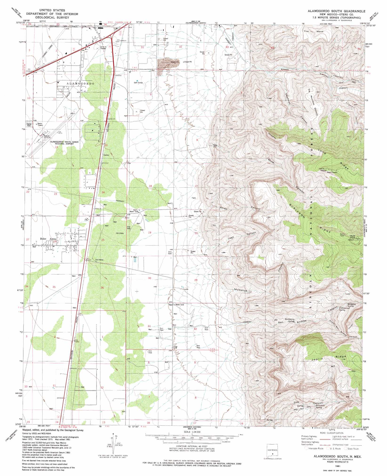
Alamogordo South Topo Map New Mexico
To zoom in, hover over the map of Alamogordo South
USGS Topo Quad 32105g8 - 1:24,000 scale
| Topo Map Name: | Alamogordo South |
| USGS Topo Quad ID: | 32105g8 |
| Print Size: | ca. 21 1/4" wide x 27" high |
| Southeast Coordinates: | 32.75° N latitude / 105.875° W longitude |
| Map Center Coordinates: | 32.8125° N latitude / 105.9375° W longitude |
| U.S. State: | NM |
| Filename: | o32105g8.jpg |
| Download Map JPG Image: | Alamogordo South topo map 1:24,000 scale |
| Map Type: | Topographic |
| Topo Series: | 7.5´ |
| Map Scale: | 1:24,000 |
| Source of Map Images: | United States Geological Survey (USGS) |
| Alternate Map Versions: |
Mule Peak NM 1976, updated 1980 Download PDF Buy paper map Alamogordo South NM 1981, updated 1982 Download PDF Buy paper map Alamogordo South NM 1981, updated 1984 Download PDF Buy paper map Alamogordo South NM 2004, updated 2006 Download PDF Buy paper map Alamogordo South NM 2011 Download PDF Buy paper map Alamogordo South NM 2013 Download PDF Buy paper map Alamogordo South NM 2017 Download PDF Buy paper map |
| FStopo: | US Forest Service topo Alamogordo South is available: Download FStopo PDF Download FStopo TIF |
1:24,000 Topo Quads surrounding Alamogordo South
Tularosa Peak |
Tularosa |
Sabinata Flat |
Domingo Peak |
Firman Canyon |
Lost River |
Malone Draw |
Alamogordo North |
High Rolls |
Cloudcroft |
Garton Lake |
Holloman |
Alamogordo South |
Sacramento Peak |
Bluff Springs |
Foster Lake |
Tres Hermanos |
Deadman Canyon |
Bug Scuffle Canyon |
Rogers Ruins |
Tres Hermanos Sw |
Tres Hermanos Se |
Pipeline Canyon |
Culp Canyon |
El Paso Canyon |
> Back to 32105e1 at 1:100,000 scale
> Back to 32104a1 at 1:250,000 scale
> Back to U.S. Topo Maps home
Alamogordo South topo map: Gazetteer
Alamogordo South: Airports
Alamo Midway Airport elevation 1287m 4222′Alamogordo-White Sands Regional Airport elevation 1269m 4163′
Alamogordo South: Mines
Alamo Number Two Pit elevation 1296m 4251′Alamogordo South: Populated Places
Boles Acres elevation 1251m 4104′Omlee elevation 1280m 4199′
Alamogordo South: Ranges
Alamo Canyon elevation 1464m 4803′Alamogordo South: Reservoirs
Taylor Tanks elevation 1291m 4235′Alamogordo South: Ridges
Burleson Ridge elevation 2315m 7595′Joplin Ridge elevation 2354m 7723′
Long Ridge elevation 2291m 7516′
Alamogordo South: Springs
Cottonwood Spring elevation 1745m 5725′Dripping Spring elevation 1825m 5987′
Fairchild Spring elevation 1670m 5479′
Hackberry Spring elevation 1533m 5029′
Alamogordo South: Summits
Mule Peak elevation 2461m 8074′Steamboat elevation 2044m 6706′
The Mesa elevation 1895m 6217′
The Roundup Ground elevation 1843m 6046′
Alamogordo South: Valleys
Arrow Canyon elevation 1377m 4517′Deadman Canyon elevation 1490m 4888′
Lead Canyon elevation 1377m 4517′
Mule Canyon elevation 1403m 4603′
Muleshoe Canyon elevation 1317m 4320′
Purgatory Canyon elevation 1644m 5393′
San Andres Canyon elevation 1378m 4520′
South San Andres Canyon elevation 1644m 5393′
Alamogordo South: Wells
10047 Water Well elevation 1280m 4199′10050 Water Well elevation 1263m 4143′
10051 Water Well elevation 1258m 4127′
10053 Water Well elevation 1279m 4196′
10054 Water Well elevation 1259m 4130′
10055 Water Well elevation 1261m 4137′
10171 Water Well elevation 1234m 4048′
10618 Water Well elevation 1268m 4160′
10619 Water Well elevation 1260m 4133′
Boles 17 Water Well elevation 1253m 4110′
Boles 35 Water Well elevation 1260m 4133′
Boles Number 12 Water Well elevation 1267m 4156′
Boles Number 13 Water Well elevation 1270m 4166′
Boles Number 14 Water Well elevation 1267m 4156′
Boles Number 15 Water Well elevation 1264m 4146′
Boles Number 16 Water Well elevation 1263m 4143′
Boles Number 3 Water Well elevation 1279m 4196′
Boles Number 4 Water Well elevation 1271m 4169′
Boles Number 5 Water Well elevation 1264m 4146′
Boles Number 7 Water Well elevation 1264m 4146′
Boles Number 9 Water Well elevation 1287m 4222′
C 4 Water Well elevation 1267m 4156′
CPS Number 3 Water Well elevation 1248m 4094′
CPS Number 4 Water Well elevation 1237m 4058′
CPS Test 2 Water Well elevation 1241m 4071′
D 5 Water Well elevation 1271m 4169′
F 7 Water Well elevation 1279m 4196′
Field Number 32 Water Well elevation 1264m 4146′
New Number 13 Water Well elevation 1267m 4156′
Number 18 or A1 Water Well elevation 1287m 4222′
Prther Number 1 Water Well elevation 1248m 4094′
T-11 Water Well elevation 1253m 4110′
T-20 Water Well elevation 1244m 4081′
T-21 Water Well elevation 1255m 4117′
T-8 Water Well elevation 1268m 4160′
Test 17 Water Well elevation 1253m 4110′
Test 4 Water Well elevation 1249m 4097′
Test Number 1 Water Well elevation 1449m 4753′
Test Number 2 Water Well elevation 1416m 4645′
TW-8 Water Well elevation 1259m 4130′
TW-9 Water Well elevation 1262m 4140′
Valmont Water Well elevation 1250m 4101′
Water Well Number 2 elevation 1243m 4078′
Alamogordo South digital topo map on disk
Buy this Alamogordo South topo map showing relief, roads, GPS coordinates and other geographical features, as a high-resolution digital map file on DVD: