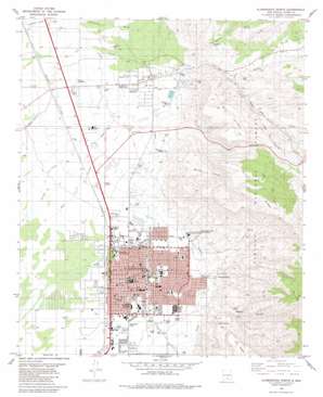
Alamogordo North Topo Map New Mexico
To zoom in, hover over the map of Alamogordo North
USGS Topo Quad 32105h8 - 1:24,000 scale
| Topo Map Name: | Alamogordo North |
| USGS Topo Quad ID: | 32105h8 |
| Print Size: | ca. 21 1/4" wide x 27" high |
| Southeast Coordinates: | 32.875° N latitude / 105.875° W longitude |
| Map Center Coordinates: | 32.9375° N latitude / 105.9375° W longitude |
| U.S. State: | NM |
| Filename: | o32105h8.jpg |
| Download Map JPG Image: | Alamogordo North topo map 1:24,000 scale |
| Map Type: | Topographic |
| Topo Series: | 7.5´ |
| Map Scale: | 1:24,000 |
| Source of Map Images: | United States Geological Survey (USGS) |
| Alternate Map Versions: |
Alamogordo NM 1976, updated 1980 Download PDF Buy paper map Alamogordo North NM 1981, updated 1982 Download PDF Buy paper map Alamogordo North NM 2004, updated 2006 Download PDF Buy paper map Alamogordo North NM 2011 Download PDF Buy paper map Alamogordo North NM 2013 Download PDF Buy paper map Alamogordo North NM 2017 Download PDF Buy paper map |
| FStopo: | US Forest Service topo Alamogordo North is available: Download FStopo PDF Download FStopo TIF |
1:24,000 Topo Quads surrounding Alamogordo North
> Back to 32105e1 at 1:100,000 scale
> Back to 32104a1 at 1:250,000 scale
> Back to U.S. Topo Maps home
Alamogordo North topo map: Gazetteer
Alamogordo North: Airports
Gorby Ranch Airport elevation 1343m 4406′Otero Mill Airport elevation 1391m 4563′
Alamogordo North: Arroyos
Laborcita Arroyo elevation 1354m 4442′Alamogordo North: Dams
Alamogordo Water Supply Reservoir Dam elevation 1357m 4452′Alamogordo North: Mines
Holmes Mine elevation 1316m 4317′Ortega Pit elevation 1396m 4580′
Alamogordo North: Parks
Alameda Park elevation 1328m 4356′Dog Canyon Historical Marker elevation 1323m 4340′
Alamogordo North: Populated Places
Alamogordo elevation 1323m 4340′Kearney elevation 1359m 4458′
La Luz elevation 1448m 4750′
Alamogordo North: Post Offices
Alamogordo Post Office elevation 1323m 4340′La Luz Post Office elevation 1448m 4750′
Alamogordo North: Ridges
Horse Ridge elevation 1878m 6161′Mill Ridge elevation 1771m 5810′
Alamogordo North: Springs
Goat Springs elevation 1570m 5150′Alamogordo North: Streams
Fresnal Creek elevation 1535m 5036′Alamogordo North: Valleys
Beeman Canyon elevation 1443m 4734′Cottonwood Wash elevation 1366m 4481′
Dillard Draw elevation 1371m 4498′
Dry Canyon elevation 1488m 4881′
Fresnal Canyon elevation 1535m 5036′
La Luz Canyon elevation 1478m 4849′
Marble Canyon elevation 2042m 6699′
Alamogordo North: Wells
10035 Water Well elevation 1404m 4606′10042 Water Well elevation 1331m 4366′
Ala Motel Water Well elevation 1334m 4376′
La Luz Number 1 Water Well elevation 1445m 4740′
Alamogordo North digital topo map on disk
Buy this Alamogordo North topo map showing relief, roads, GPS coordinates and other geographical features, as a high-resolution digital map file on DVD:


