La Mesa Topo Map New Mexico
To zoom in, hover over the map of La Mesa
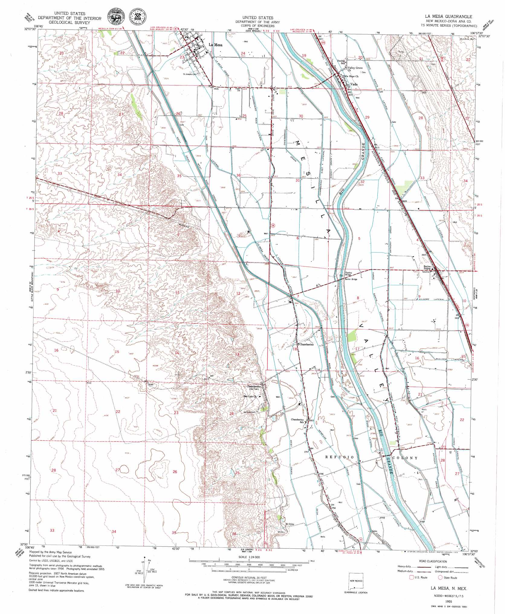
USGS Topo Quad 32106a6 - 1:24,000 scale
| Topo Map Name: | La Mesa |
| USGS Topo Quad ID: | 32106a6 |
| Print Size: | ca. 21 1/4" wide x 27" high |
| Southeast Coordinates: | 32° N latitude / 106.625° W longitude |
| Map Center Coordinates: | 32.0625° N latitude / 106.6875° W longitude |
| U.S. State: | NM |
| Filename: | o32106a6.jpg |
| Download Map JPG Image: | La Mesa topo map 1:24,000 scale |
| Map Type: | Topographic |
| Topo Series: | 7.5´ |
| Map Scale: | 1:24,000 |
| Source of Map Images: | United States Geological Survey (USGS) |
| Alternate Map Versions: |
La Mesa NM 1955, updated 1962 Download PDF Buy paper map La Mesa NM 1955, updated 1979 Download PDF Buy paper map La Mesa NM 1996, updated 2002 Download PDF Buy paper map La Mesa NM 2010 Download PDF Buy paper map La Mesa NM 2013 Download PDF Buy paper map La Mesa NM 2017 Download PDF Buy paper map |
1:24,000 Topo Quads surrounding La Mesa
Picacho Mountain |
Las Cruces |
Tortugas Mountain |
Organ Peak |
Davies Tank |
Afton Nw |
Black Mesa |
San Miguel |
Bishop Cap |
Newman Nw |
Afton |
Little Black Mountain |
La Mesa |
Anthony |
Newman Sw |
Kilbourne Hole |
Lanark |
La Union |
Canutillo |
North Franklin Mountain |
Potrillo |
Noria |
Strauss |
Smeltertown |
El Paso |
> Back to 32106a1 at 1:100,000 scale
> Back to 32106a1 at 1:250,000 scale
> Back to U.S. Topo Maps home
La Mesa topo map: Gazetteer
La Mesa: Bridges
Berino Bridge elevation 1160m 3805′Pipeline Bridge elevation 1160m 3805′
La Mesa: Canals
Anthony Drain elevation 1158m 3799′Bullock Lateral elevation 1159m 3802′
Chamberino Drain elevation 1163m 3815′
Chamberino East Lateral elevation 1165m 3822′
Deck Lateral elevation 1156m 3792′
Jiminez Lateral elevation 1157m 3795′
Kilgore Lateral elevation 1162m 3812′
La Union Main Canal elevation 1159m 3802′
Lower Chamberino Lateral elevation 1159m 3802′
Nemexas Drain elevation 1157m 3795′
Rigney Drain elevation 1163m 3815′
Three Saints Lateral elevation 1161m 3809′
Three Saints West Lateral elevation 1159m 3802′
Wood Lateral elevation 1159m 3802′
La Mesa: Dams
Apodaca Arroyo Dam elevation 1175m 3854′La Mesa: Populated Places
Chamberino elevation 1160m 3805′Chamberino elevation 1165m 3822′
El Ojito elevation 1160m 3805′
La Mesa elevation 1166m 3825′
Vado elevation 1165m 3822′
La Mesa: Post Offices
Chamberino Post Office elevation 1160m 3805′La Mesa Post Office (historical) elevation 1166m 3825′
Vado Post Office (historical) elevation 1165m 3822′
La Mesa: Wells
10058 Water Well elevation 1166m 3825′10066 Water Well elevation 1162m 3812′
10121 Water Well elevation 1157m 3795′
10122 Water Well elevation 1161m 3809′
Bern W 150 Water Well elevation 1162m 3812′
Hutchins Well elevation 1217m 3992′
J 2 Water Well elevation 1158m 3799′
J 3 Water Well elevation 1156m 3792′
K 23 Water Well elevation 1156m 3792′
LM-2 Water Well elevation 1162m 3812′
LM-5 Water Well elevation 1161m 3809′
LM-7 Water Well elevation 1156m 3792′
TW-5 Water Well elevation 1164m 3818′
United States Bureau of Reclamation 5 Water Well elevation 1164m 3818′
Vado 1300 Water Well elevation 1164m 3818′
W Resource Water Well elevation 1163m 3815′
La Mesa digital topo map on disk
Buy this La Mesa topo map showing relief, roads, GPS coordinates and other geographical features, as a high-resolution digital map file on DVD: