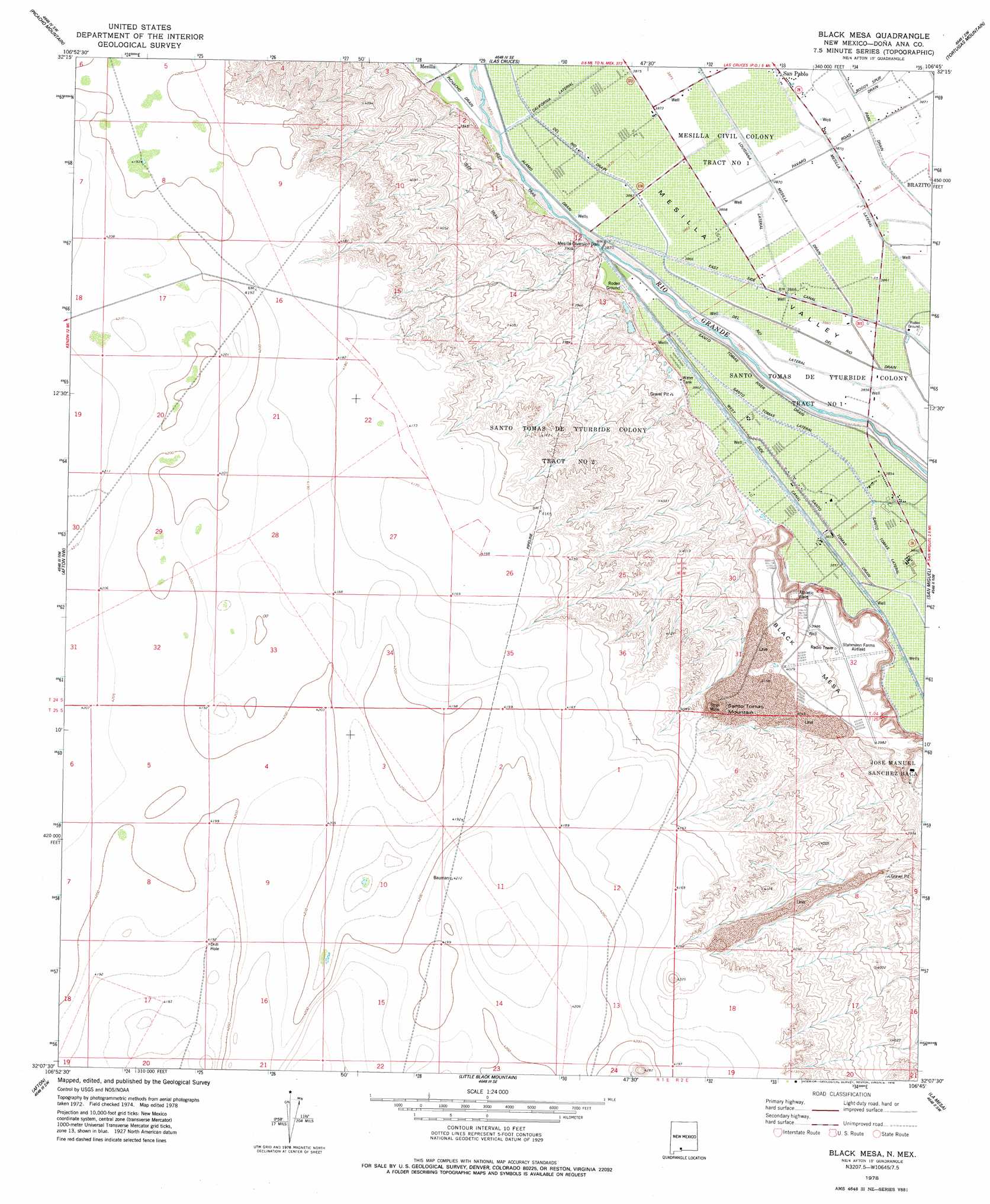
Black Mesa Topo Map New Mexico
To zoom in, hover over the map of Black Mesa
USGS Topo Quad 32106b7 - 1:24,000 scale
| Topo Map Name: | Black Mesa |
| USGS Topo Quad ID: | 32106b7 |
| Print Size: | ca. 21 1/4" wide x 27" high |
| Southeast Coordinates: | 32.125° N latitude / 106.75° W longitude |
| Map Center Coordinates: | 32.1875° N latitude / 106.8125° W longitude |
| U.S. State: | NM |
| Filename: | o32106b7.jpg |
| Download Map JPG Image: | Black Mesa topo map 1:24,000 scale |
| Map Type: | Topographic |
| Topo Series: | 7.5´ |
| Map Scale: | 1:24,000 |
| Source of Map Images: | United States Geological Survey (USGS) |
| Alternate Map Versions: |
Black Mesa NM 1996, updated 2001 Download PDF Buy paper map Black Mesa NM 2010 Download PDF Buy paper map Black Mesa NM 2013 Download PDF Buy paper map Black Mesa NM 2017 Download PDF Buy paper map |
1:24,000 Topo Quads surrounding Black Mesa
Rough And Ready Hills |
Leasburg |
Dona Ana |
Organ Peak Nw |
Organ |
Sleeping Lady Hills |
Picacho Mountain |
Las Cruces |
Tortugas Mountain |
Organ Peak |
Aden Hills |
Afton Nw |
Black Mesa |
San Miguel |
Bishop Cap |
Aden Crater |
Afton |
Little Black Mountain |
La Mesa |
Anthony |
Mount Riley |
Kilbourne Hole |
Lanark |
La Union |
Canutillo |
> Back to 32106a1 at 1:100,000 scale
> Back to 32106a1 at 1:250,000 scale
> Back to U.S. Topo Maps home
Black Mesa topo map: Gazetteer
Black Mesa: Canals
Del Rio Drain elevation 1177m 3861′Del Rio Lateral elevation 1176m 3858′
Louisiana Lateral elevation 1179m 3868′
Park Drain elevation 1179m 3868′
Santo Tomas Lateral elevation 1176m 3858′
Black Mesa: Dams
Mesilla Diversion Dam elevation 1179m 3868′Black Mesa: Populated Places
San Pablo elevation 1181m 3874′Black Mesa: Summits
Black Mesa elevation 1249m 4097′Santo Tomas Mountain elevation 1285m 4215′
Black Mesa: Wells
M-1A Water Well elevation 1176m 3858′M-1B Water Well elevation 1176m 3858′
M-1C Water Well elevation 1176m 3858′
M-2A Water Well elevation 1177m 3861′
M-2B Water Well elevation 1177m 3861′
M-2C Water Well elevation 1177m 3861′
United States Bureau of Reclamation 48 Water Well elevation 1180m 3871′
Black Mesa digital topo map on disk
Buy this Black Mesa topo map showing relief, roads, GPS coordinates and other geographical features, as a high-resolution digital map file on DVD: