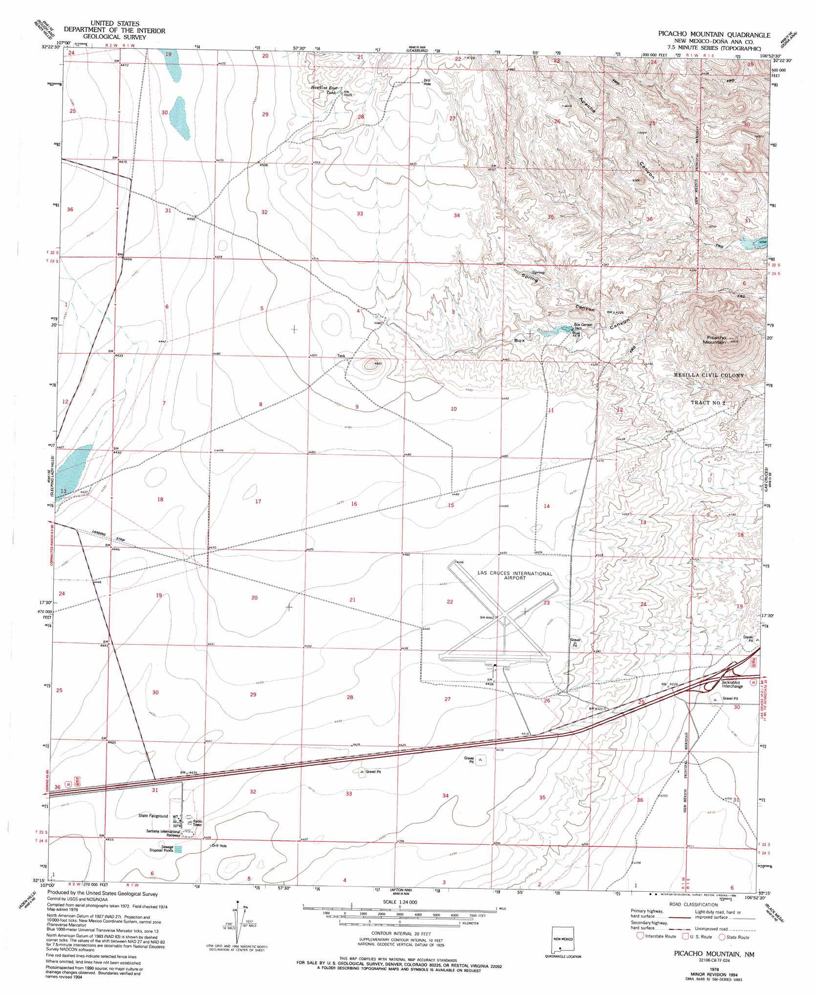
Picacho Mountain Topo Map New Mexico
To zoom in, hover over the map of Picacho Mountain
USGS Topo Quad 32106c8 - 1:24,000 scale
| Topo Map Name: | Picacho Mountain |
| USGS Topo Quad ID: | 32106c8 |
| Print Size: | ca. 21 1/4" wide x 27" high |
| Southeast Coordinates: | 32.25° N latitude / 106.875° W longitude |
| Map Center Coordinates: | 32.3125° N latitude / 106.9375° W longitude |
| U.S. State: | NM |
| Filename: | o32106c8.jpg |
| Download Map JPG Image: | Picacho Mountain topo map 1:24,000 scale |
| Map Type: | Topographic |
| Topo Series: | 7.5´ |
| Map Scale: | 1:24,000 |
| Source of Map Images: | United States Geological Survey (USGS) |
| Alternate Map Versions: |
Picacho Mountain NM 1978, updated 1994 Download PDF Buy paper map Picacho Mountain NM 1996, updated 2002 Download PDF Buy paper map Picacho Mountain NM 2010 Download PDF Buy paper map Picacho Mountain NM 2013 Download PDF Buy paper map Picacho Mountain NM 2017 Download PDF Buy paper map |
1:24,000 Topo Quads surrounding Picacho Mountain
Souse Springs |
Sierra Alta |
Seldon Canyon |
Summerford Mountain |
Taylor Well |
Magdalena Peak |
Rough And Ready Hills |
Leasburg |
Dona Ana |
Organ Peak Nw |
Magdalena Gap |
Sleeping Lady Hills |
Picacho Mountain |
Las Cruces |
Tortugas Mountain |
Mount Aden |
Aden Hills |
Afton Nw |
Black Mesa |
San Miguel |
Mount Aden Sw |
Aden Crater |
Afton |
Little Black Mountain |
La Mesa |
> Back to 32106a1 at 1:100,000 scale
> Back to 32106a1 at 1:250,000 scale
> Back to U.S. Topo Maps home
Picacho Mountain topo map: Gazetteer
Picacho Mountain: Airports
Las Cruces International Airport elevation 1354m 4442′Picacho Mountain: Crossings
131 Airport Interchange elevation 1346m 4416′135-US 70 Jack Rabbit Interchange elevation 1279m 4196′
Jackrabbit Interchange elevation 1279m 4196′
Picacho Mountain: Dams
Box Canyon Dam elevation 1311m 4301′Picacho North Dam elevation 1260m 4133′
Picacho South Dam elevation 1333m 4373′
Picacho Mountain: Mines
Lauer Claims elevation 1323m 4340′Picacho Mountain: Reservoirs
Hawkins East Tank elevation 1401m 4596′Picacho Mountain: Summits
Picacho Mountain elevation 1510m 4954′Picacho Mountain: Valleys
Spring Canyon elevation 1291m 4235′Picacho Mountain digital topo map on disk
Buy this Picacho Mountain topo map showing relief, roads, GPS coordinates and other geographical features, as a high-resolution digital map file on DVD: