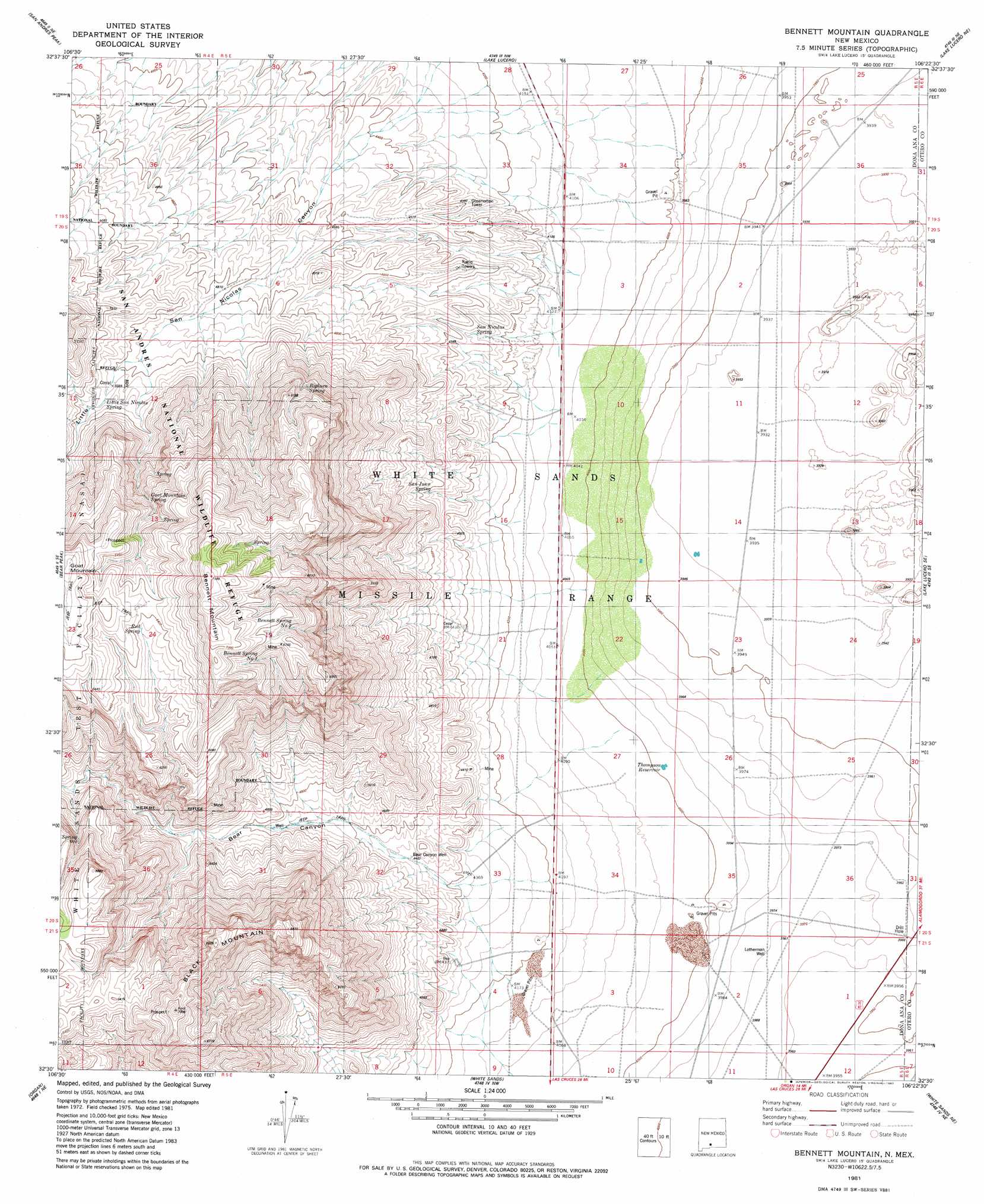
Bennett Mountain Topo Map New Mexico
To zoom in, hover over the map of Bennett Mountain
USGS Topo Quad 32106e4 - 1:24,000 scale
| Topo Map Name: | Bennett Mountain |
| USGS Topo Quad ID: | 32106e4 |
| Print Size: | ca. 21 1/4" wide x 27" high |
| Southeast Coordinates: | 32.5° N latitude / 106.375° W longitude |
| Map Center Coordinates: | 32.5625° N latitude / 106.4375° W longitude |
| U.S. State: | NM |
| Filename: | o32106e4.jpg |
| Download Map JPG Image: | Bennett Mountain topo map 1:24,000 scale |
| Map Type: | Topographic |
| Topo Series: | 7.5´ |
| Map Scale: | 1:24,000 |
| Source of Map Images: | United States Geological Survey (USGS) |
| Alternate Map Versions: |
Lake Lucero SW NM 1948, updated 1973 Download PDF Buy paper map Lake Lucero SW NM 1950 Download PDF Buy paper map Bennett Mountain NM 1981, updated 1982 Download PDF Buy paper map Bennett Mountain NM 2010 Download PDF Buy paper map Bennett Mountain NM 2013 Download PDF Buy paper map Bennett Mountain NM 2017 Download PDF Buy paper map |
1:24,000 Topo Quads surrounding Bennett Mountain
Fleck Draw |
Gardner Peak |
Heart Of The Sands Sw |
Heart Of The Sands |
Garton Lake |
Goldenburg Draw |
San Andres Peak |
Lake Lucero |
Lake Lucero Ne |
Foster Lake |
Taylor Well |
Bear Peak |
Bennett Mountain |
Lake Lucero Se |
Tres Hermanos Sw |
Organ Peak Nw |
Organ |
White Sands |
White Sands Ne |
Elephant Mountain |
Tortugas Mountain |
Organ Peak |
Davies Tank |
White Sands Se |
Elwood |
> Back to 32106e1 at 1:100,000 scale
> Back to 32106a1 at 1:250,000 scale
> Back to U.S. Topo Maps home
Bennett Mountain topo map: Gazetteer
Bennett Mountain: Mines
Missle Pits elevation 1200m 3937′Bennett Mountain: Reservoirs
Thompson Reservoir elevation 1206m 3956′Tompson Reservoir elevation 1219m 3999′
Bennett Mountain: Springs
Red Spring elevation 1960m 6430′San Juan Spring elevation 1376m 4514′
San Nicolas Spring elevation 1316m 4317′
Bennett Mountain: Summits
Bennett Mountain elevation 2188m 7178′Black Mountain elevation 2133m 6998′
Goat Mountain elevation 2042m 6699′
Bennett Mountain: Valleys
Bear Canyon elevation 1233m 4045′Bennett Mountain: Wells
Bear Canyon Well elevation 1367m 4484′Lethermans Well elevation 1211m 3973′
Bennett Mountain digital topo map on disk
Buy this Bennett Mountain topo map showing relief, roads, GPS coordinates and other geographical features, as a high-resolution digital map file on DVD: