Taylor Well Topo Map New Mexico
To zoom in, hover over the map of Taylor Well
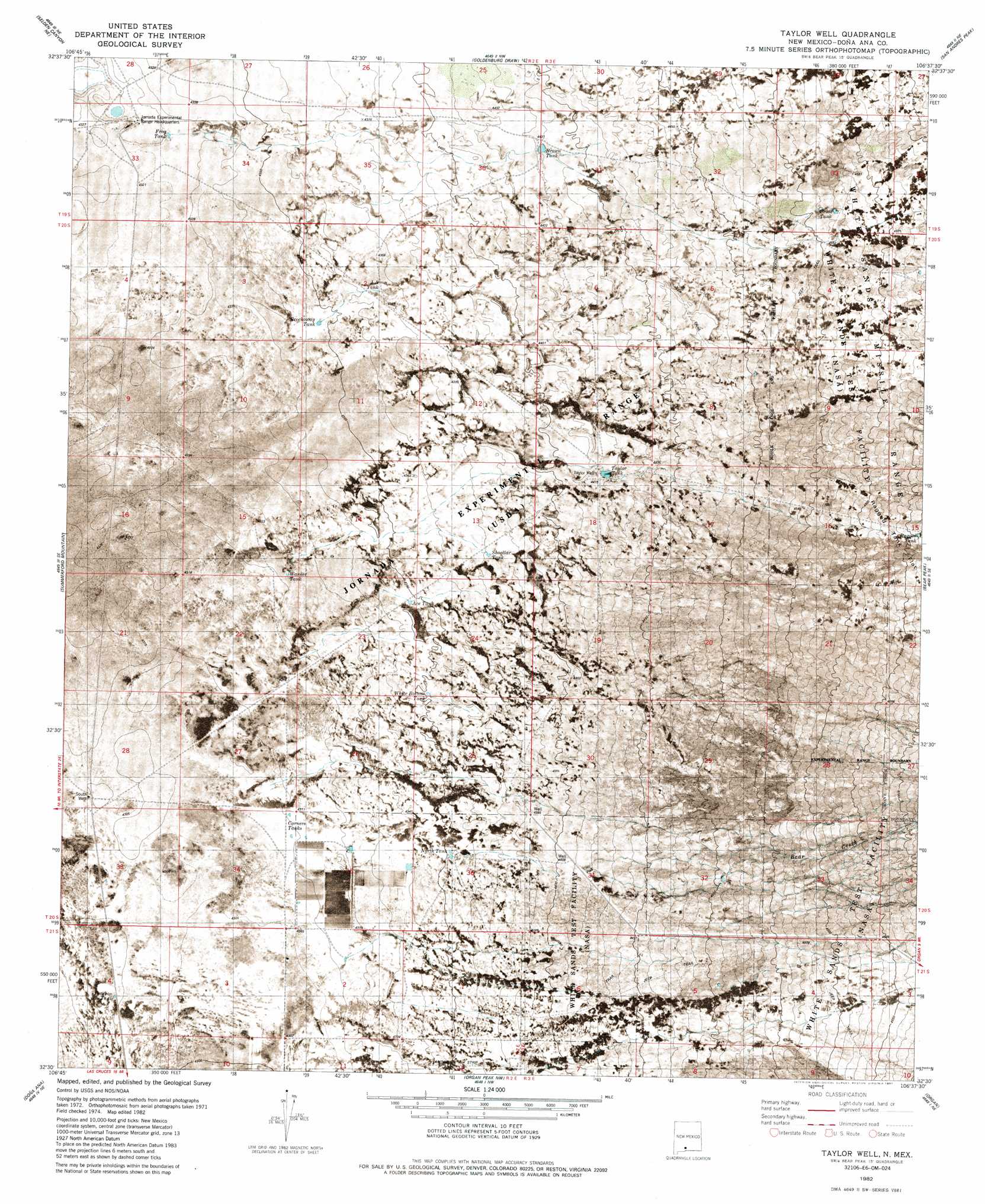
USGS Topo Quad 32106e6 - 1:24,000 scale
| Topo Map Name: | Taylor Well |
| USGS Topo Quad ID: | 32106e6 |
| Print Size: | ca. 21 1/4" wide x 27" high |
| Southeast Coordinates: | 32.5° N latitude / 106.625° W longitude |
| Map Center Coordinates: | 32.5625° N latitude / 106.6875° W longitude |
| U.S. State: | NM |
| Filename: | p32106e6.jpg |
| Download Map JPG Image: | Taylor Well topo map 1:24,000 scale |
| Map Type: | Orthophoto |
| Topo Series: | 7.5´ |
| Map Scale: | 1:24,000 |
| Source of Map Images: | United States Geological Survey (USGS) |
| Alternate Map Versions: |
Taylor Well NM 1982, updated 1982 Download PDF Buy paper map Taylor Well NM 1982, updated 1987 Download PDF Buy paper map Taylor Well NM 1996, updated 2002 Download PDF Buy paper map Taylor Well NM 2010 Download PDF Buy paper map Taylor Well NM 2013 Download PDF Buy paper map Taylor Well NM 2017 Download PDF Buy paper map |
1:24,000 Topo Quads surrounding Taylor Well
Upham Hills |
Gilmore Draw |
Fleck Draw |
Gardner Peak |
Heart Of The Sands Sw |
Thorn Well |
Seldon Canyon Ne |
Goldenburg Draw |
San Andres Peak |
Lake Lucero |
Seldon Canyon |
Summerford Mountain |
Taylor Well |
Bear Peak |
Bennett Mountain |
Leasburg |
Dona Ana |
Organ Peak Nw |
Organ |
White Sands |
Picacho Mountain |
Las Cruces |
Tortugas Mountain |
Organ Peak |
Davies Tank |
> Back to 32106e1 at 1:100,000 scale
> Back to 32106a1 at 1:250,000 scale
> Back to U.S. Topo Maps home
Taylor Well topo map: Gazetteer
Taylor Well: Airports
Waids Airpark elevation 1330m 4363′Taylor Well: Reservoirs
Ace Tank elevation 1326m 4350′Brockoway Tank elevation 1326m 4350′
Brown Tank elevation 1354m 4442′
Corners Tanks elevation 1314m 4311′
Cross Tank elevation 1393m 4570′
Frog Tank elevation 1314m 4311′
J A Tank elevation 1331m 4366′
North Tank elevation 1327m 4353′
Pearson Tank elevation 1315m 4314′
Ragged Tank elevation 1422m 4665′
Shoellar Tank elevation 1333m 4373′
Taylor Tank elevation 1347m 4419′
Warner Tank elevation 1318m 4324′
White Bottom Tank elevation 1327m 4353′
Taylor Well: Streams
Bear Creek elevation 1395m 4576′Taylor Well: Wells
South Well elevation 1314m 4311′Taylor Well elevation 1346m 4416′
Taylor Well digital topo map on disk
Buy this Taylor Well topo map showing relief, roads, GPS coordinates and other geographical features, as a high-resolution digital map file on DVD: