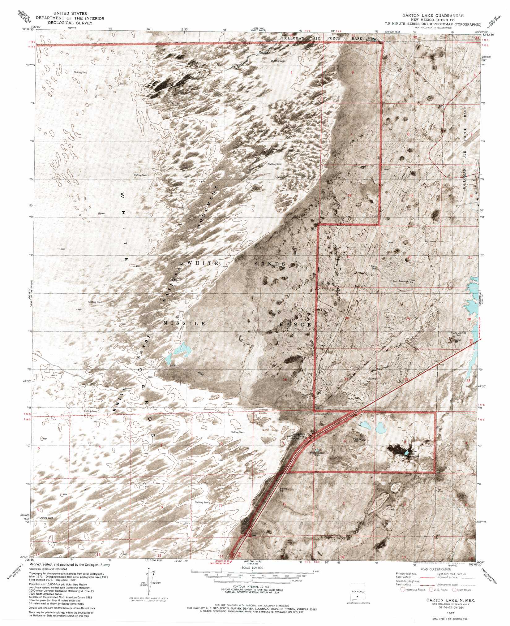
Garton Lake Topo Map New Mexico
To zoom in, hover over the map of Garton Lake
USGS Topo Quad 32106g2 - 1:24,000 scale
| Topo Map Name: | Garton Lake |
| USGS Topo Quad ID: | 32106g2 |
| Print Size: | ca. 21 1/4" wide x 27" high |
| Southeast Coordinates: | 32.75° N latitude / 106.125° W longitude |
| Map Center Coordinates: | 32.8125° N latitude / 106.1875° W longitude |
| U.S. State: | NM |
| Filename: | p32106g2.jpg |
| Download Map JPG Image: | Garton Lake topo map 1:24,000 scale |
| Map Type: | Orthophoto |
| Topo Series: | 7.5´ |
| Map Scale: | 1:24,000 |
| Source of Map Images: | United States Geological Survey (USGS) |
| Alternate Map Versions: |
Holloman SW NM 1976, updated 1980 Download PDF Buy paper map Garton Lake NM 1982, updated 1982 Download PDF Buy paper map Garton Lake NM 1982, updated 1987 Download PDF Buy paper map Garton Lake NM 2010 Download PDF Buy paper map Garton Lake NM 2013 Download PDF Buy paper map Garton Lake NM 2017 Download PDF Buy paper map |
1:24,000 Topo Quads surrounding Garton Lake
Lumley Lake |
Fifteenmile Lake |
Tularosa Peak |
Tularosa |
Sabinata Flat |
Heart Of The Sands Nw |
Heart Of The Sands Ne |
Lost River |
Malone Draw |
Alamogordo North |
Heart Of The Sands Sw |
Heart Of The Sands |
Garton Lake |
Holloman |
Alamogordo South |
Lake Lucero |
Lake Lucero Ne |
Foster Lake |
Tres Hermanos |
Deadman Canyon |
Bennett Mountain |
Lake Lucero Se |
Tres Hermanos Sw |
Tres Hermanos Se |
Pipeline Canyon |
> Back to 32106e1 at 1:100,000 scale
> Back to 32106a1 at 1:250,000 scale
> Back to U.S. Topo Maps home
Garton Lake topo map: Gazetteer
Garton Lake: Channels
White Sands Gate elevation 1218m 3996′Garton Lake: Dams
Holloman Lake Dam elevation 1234m 4048′Garton Lake: Lakes
Garton Lake elevation 1220m 4002′Garton Lake: Mines
Carton Well elevation 1219m 3999′White Sands Gypsum elevation 1238m 4061′
Garton Lake: Reservoirs
Holloman Lake elevation 1234m 4048′Garton Lake: Springs
Hurtz Spring elevation 1232m 4041′Garton Lake: Streams
Lost River elevation 1220m 4002′Garton Lake: Wells
Garton Water Well elevation 1220m 4002′Garton Well elevation 1220m 4002′
Sunspt Number 1 Water Well elevation 1220m 4002′
Garton Lake digital topo map on disk
Buy this Garton Lake topo map showing relief, roads, GPS coordinates and other geographical features, as a high-resolution digital map file on DVD: