Florida Topo Map New Mexico
To zoom in, hover over the map of Florida
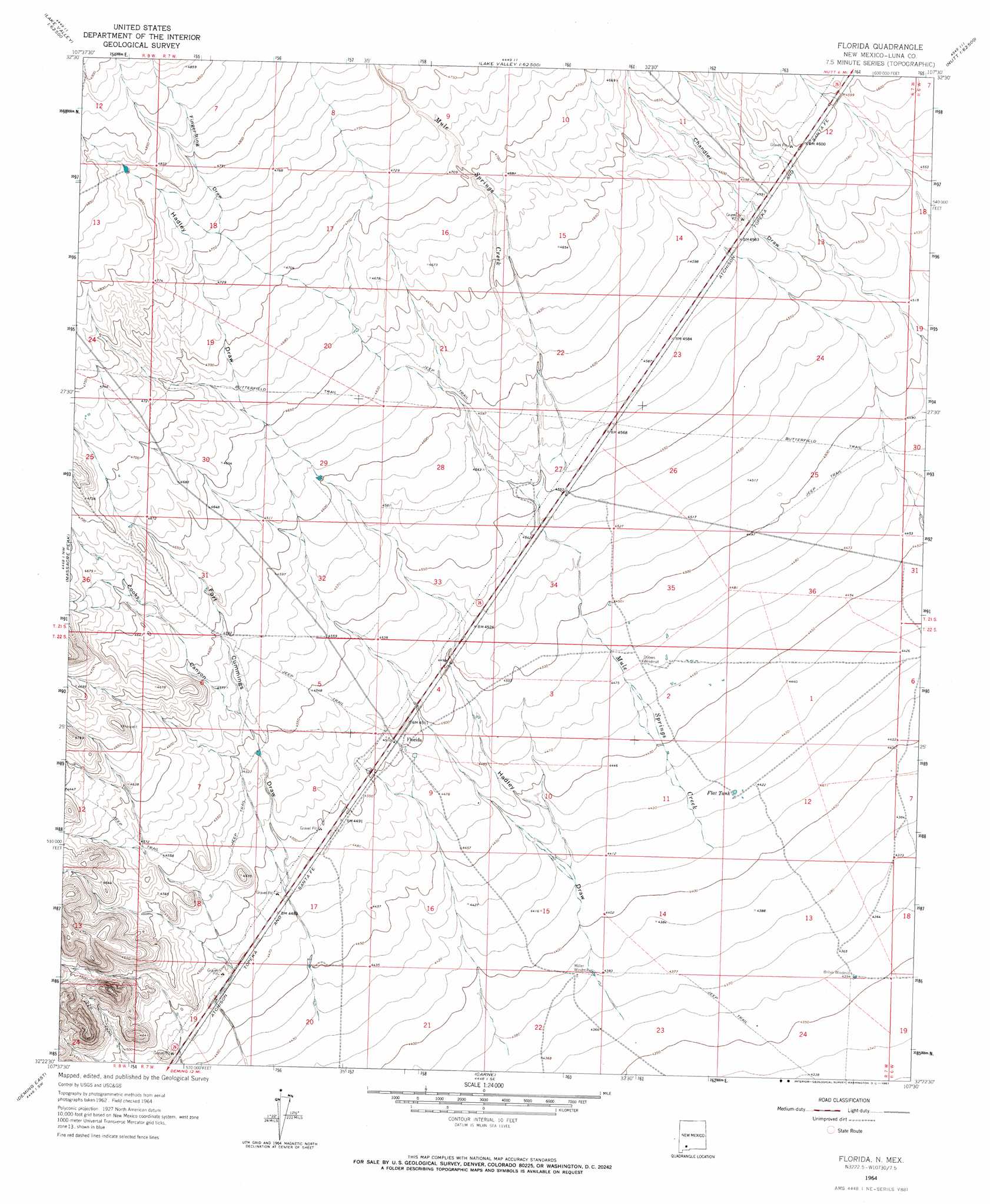
USGS Topo Quad 32107d5 - 1:24,000 scale
| Topo Map Name: | Florida |
| USGS Topo Quad ID: | 32107d5 |
| Print Size: | ca. 21 1/4" wide x 27" high |
| Southeast Coordinates: | 32.375° N latitude / 107.5° W longitude |
| Map Center Coordinates: | 32.4375° N latitude / 107.5625° W longitude |
| U.S. State: | NM |
| Filename: | o32107d5.jpg |
| Download Map JPG Image: | Florida topo map 1:24,000 scale |
| Map Type: | Topographic |
| Topo Series: | 7.5´ |
| Map Scale: | 1:24,000 |
| Source of Map Images: | United States Geological Survey (USGS) |
| Alternate Map Versions: |
Florida NM 1964, updated 1967 Download PDF Buy paper map Florida NM 2010 Download PDF Buy paper map Florida NM 2013 Download PDF Buy paper map Florida NM 2017 Download PDF Buy paper map |
1:24,000 Topo Quads surrounding Florida
Dwyer |
Whiterock Mountain |
Lake Valley |
Jug Canyon |
Arroyo Cuervo |
Faywood Se |
Ok Canyon |
Greg Hills |
Nutt |
Hockett |
Goat Ridge |
Massacre Peak |
Florida |
Good Sight Peak |
Good Sight Peak Ne |
Deming West |
Deming East |
Carne |
Myndus |
Lazy E Ranch |
Bowlin Ranch |
Capitol Dome |
Florida Gap |
Akela |
Cambray |
> Back to 32107a1 at 1:100,000 scale
> Back to 32106a1 at 1:250,000 scale
> Back to U.S. Topo Maps home
Florida topo map: Gazetteer
Florida: Populated Places
Florida elevation 1374m 4507′Florida: Post Offices
Florida Post Office (historical) elevation 1374m 4507′Florida: Reservoirs
Flat Tank elevation 1349m 4425′Florida: Springs
Cooks Spring Historic Site elevation 1374m 4507′Florida: Streams
Mule Springs Creek elevation 1345m 4412′Florida: Valleys
Cookes Canyon elevation 1391m 4563′Finger-Ring Draw elevation 1451m 4760′
Fort Cummings Draw elevation 1350m 4429′
Hadley Draw elevation 1332m 4370′
Florida: Wells
01207 Water Well elevation 1338m 4389′01213 Water Well elevation 1361m 4465′
01214 Water Well elevation 1376m 4514′
01215 Water Well elevation 1402m 4599′
01217 Water Well elevation 1333m 4373′
01218 Water Well elevation 1334m 4376′
01276 Water Well elevation 1388m 4553′
01583 Water Well elevation 1364m 4475′
10468 Water Well elevation 1335m 4379′
Florida digital topo map on disk
Buy this Florida topo map showing relief, roads, GPS coordinates and other geographical features, as a high-resolution digital map file on DVD: