Taylor Mountain Topo Map New Mexico
To zoom in, hover over the map of Taylor Mountain
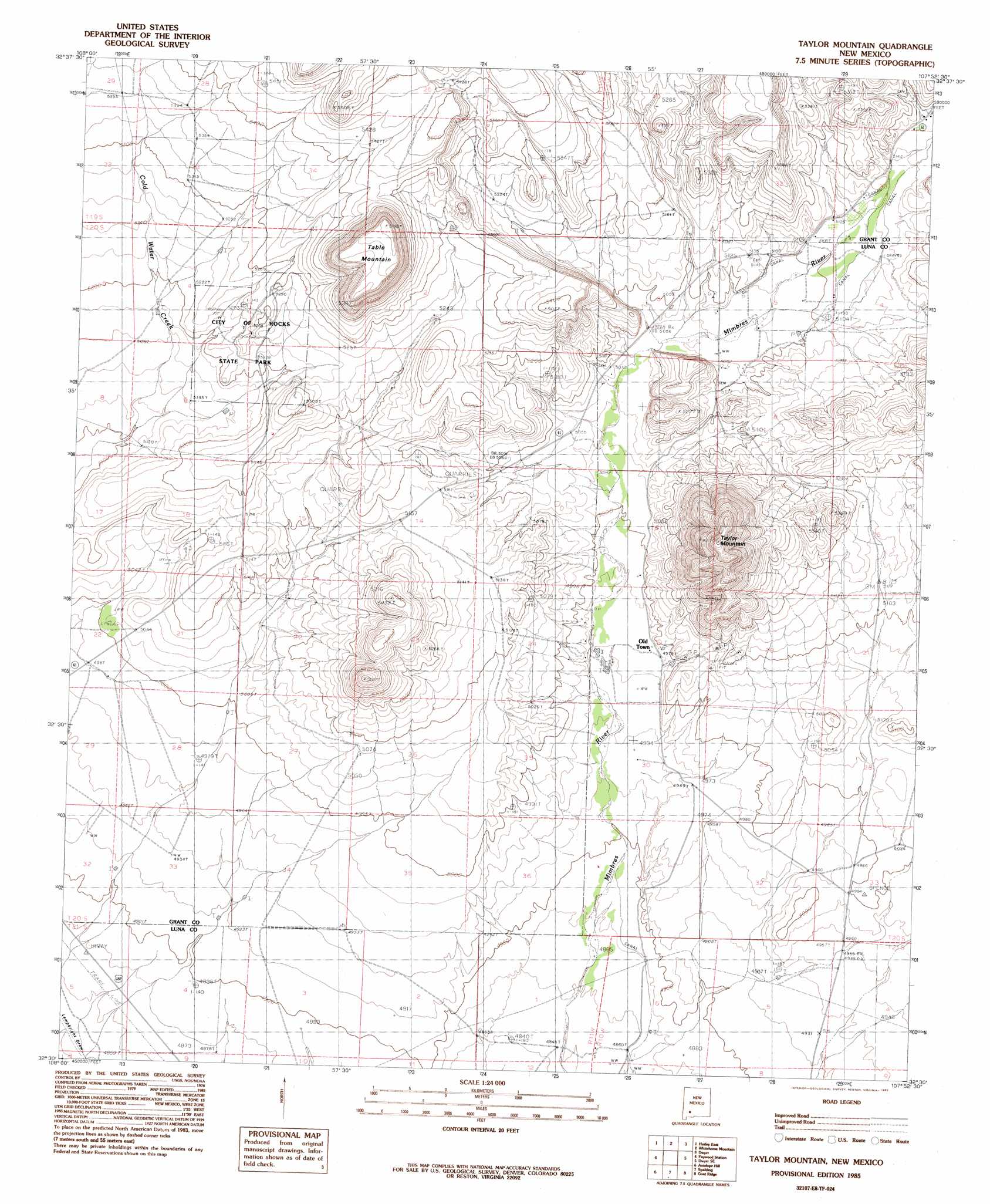
USGS Topo Quad 32107e8 - 1:24,000 scale
| Topo Map Name: | Taylor Mountain |
| USGS Topo Quad ID: | 32107e8 |
| Print Size: | ca. 21 1/4" wide x 27" high |
| Southeast Coordinates: | 32.5° N latitude / 107.875° W longitude |
| Map Center Coordinates: | 32.5625° N latitude / 107.9375° W longitude |
| U.S. State: | NM |
| Filename: | o32107e8.jpg |
| Download Map JPG Image: | Taylor Mountain topo map 1:24,000 scale |
| Map Type: | Topographic |
| Topo Series: | 7.5´ |
| Map Scale: | 1:24,000 |
| Source of Map Images: | United States Geological Survey (USGS) |
| Alternate Map Versions: |
Taylor Mountain NM 1985, updated 1985 Download PDF Buy paper map Taylor Mountain NM 2010 Download PDF Buy paper map Taylor Mountain NM 2013 Download PDF Buy paper map |
1:24,000 Topo Quads surrounding Taylor Mountain
Fort Bayard |
Santa Rita |
San Lorenzo |
Maverick Mountain |
Pa Mountain |
Hurley West |
Hurley East |
Whitehorse Mountain |
Dwyer |
Whiterock Mountain |
Whitewater |
Faywood Station |
Taylor Mountain |
Faywood Se |
Ok Canyon |
Cow Springs Mountain |
Antelope Hill |
Spalding |
Goat Ridge |
Massacre Peak |
Grandmother Mountain West |
Grandmother Mountain East |
Williams Ranch |
Deming West |
Deming East |
> Back to 32107e1 at 1:100,000 scale
> Back to 32106a1 at 1:250,000 scale
> Back to U.S. Topo Maps home
Taylor Mountain topo map: Gazetteer
Taylor Mountain: Arches
City of Rocks Arch elevation 1608m 5275′Taylor Mountain: Parks
City of Rocks State Park elevation 1605m 5265′Taylor Mountain: Populated Places
Old Town elevation 1518m 4980′Taylor Mountain: Reservoirs
Mimbres Tank elevation 1636m 5367′Taylor Mountain: Springs
Faywood Hot Spring elevation 1530m 5019′Taylor Mountain: Summits
Table Mountain elevation 1753m 5751′Taylor Mountain elevation 1776m 5826′
Taylor Mountain: Valleys
Negro Canyon elevation 1544m 5065′Taylor Mountain: Wells
01488 Water Well elevation 1551m 5088′01489 Water Well elevation 1551m 5088′
01490 Water Well elevation 1549m 5082′
01491 Water Well elevation 1549m 5082′
01492 Water Well elevation 1555m 5101′
01495 Water Well elevation 1506m 4940′
01497 Water Well elevation 1492m 4895′
01529 Water Well elevation 1560m 5118′
01530 Water Well elevation 1560m 5118′
01536 Water Well elevation 1551m 5088′
01537 Water Well elevation 1545m 5068′
01540 Water Well elevation 1515m 4970′
01541 Water Well elevation 1537m 5042′
01543 Water Well elevation 1549m 5082′
01549 Water Well elevation 1549m 5082′
01550 Water Well elevation 1543m 5062′
01553 Water Well elevation 1531m 5022′
01555 Water Well elevation 1549m 5082′
01556 Water Well elevation 1549m 5082′
01560 Water Well elevation 1577m 5173′
01562 Water Well elevation 1531m 5022′
01563 Water Well elevation 1520m 4986′
10022 Water Well elevation 1492m 4895′
10023 Water Well elevation 1489m 4885′
10024 Water Well elevation 1481m 4858′
Taylor Mountain digital topo map on disk
Buy this Taylor Mountain topo map showing relief, roads, GPS coordinates and other geographical features, as a high-resolution digital map file on DVD: