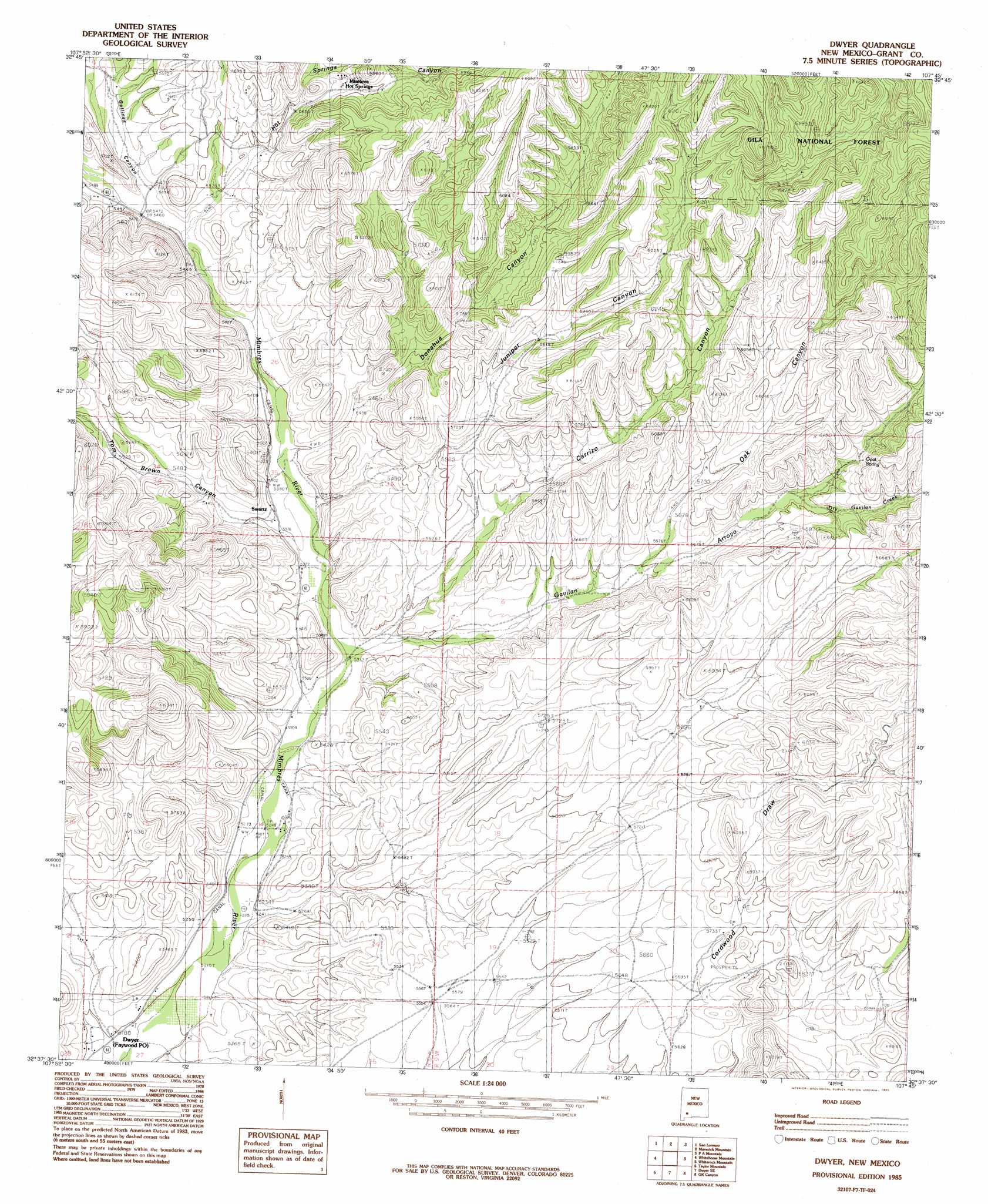
Dwyer Topo Map New Mexico
To zoom in, hover over the map of Dwyer
USGS Topo Quad 32107f7 - 1:24,000 scale
| Topo Map Name: | Dwyer |
| USGS Topo Quad ID: | 32107f7 |
| Print Size: | ca. 21 1/4" wide x 27" high |
| Southeast Coordinates: | 32.625° N latitude / 107.75° W longitude |
| Map Center Coordinates: | 32.6875° N latitude / 107.8125° W longitude |
| U.S. State: | NM |
| Filename: | o32107f7.jpg |
| Download Map JPG Image: | Dwyer topo map 1:24,000 scale |
| Map Type: | Topographic |
| Topo Series: | 7.5´ |
| Map Scale: | 1:24,000 |
| Source of Map Images: | United States Geological Survey (USGS) |
| Alternate Map Versions: |
Dwyer NM 1985, updated 1985 Download PDF Buy paper map Dwyer NM 1999, updated 2002 Download PDF Buy paper map Dwyer NM 2011 Download PDF Buy paper map Dwyer NM 2013 Download PDF Buy paper map Dwyer NM 2017 Download PDF Buy paper map |
| FStopo: | US Forest Service topo Dwyer is available: Download FStopo PDF Download FStopo TIF |
1:24,000 Topo Quads surrounding Dwyer
Allie Canyon |
Hendricks Peak |
Hillsboro Peak |
Kingston |
Hillsboro |
Santa Rita |
San Lorenzo |
Maverick Mountain |
Pa Mountain |
Mcclede Mountain |
Hurley East |
Whitehorse Mountain |
Dwyer |
Whiterock Mountain |
Lake Valley |
Faywood Station |
Taylor Mountain |
Faywood Se |
Ok Canyon |
Greg Hills |
Antelope Hill |
Spalding |
Goat Ridge |
Massacre Peak |
Florida |
> Back to 32107e1 at 1:100,000 scale
> Back to 32106a1 at 1:250,000 scale
> Back to U.S. Topo Maps home
Dwyer topo map: Gazetteer
Dwyer: Populated Places
Dwyer elevation 1585m 5200′Dwyer: Post Offices
Dwyer Post Office (historical) elevation 1585m 5200′Faywood Post Office elevation 1585m 5200′
Dwyer: Reservoirs
Dwyer Reservoir elevation 1868m 6128′Parra Tank elevation 1944m 6377′
Dwyer: Springs
Goat Spring elevation 1800m 5905′Mimbres Cold Springs elevation 1790m 5872′
Mimbres Hot Springs elevation 1762m 5780′
Dwyer: Streams
Dry Gavilan Creek elevation 1759m 5770′Dry Gavilan Creek elevation 1754m 5754′
Dry Gavilan Creek elevation 1768m 5800′
Gavilan Arroyo elevation 1622m 5321′
Gavilan Creek elevation 1779m 5836′
Macho Creek elevation 1714m 5623′
Dwyer: Valleys
Carrizo Canyon elevation 1641m 5383′Cold Springs Canyon elevation 1736m 5695′
Cordwood Draw elevation 1776m 5826′
Donahue Canyon elevation 1646m 5400′
Gallinas Canyon elevation 1677m 5501′
Hot Springs Canyon elevation 1681m 5515′
Juniper Canyon elevation 1661m 5449′
Oak Canyon elevation 1709m 5606′
Tom Brown Canyon elevation 1641m 5383′
Dwyer: Wells
00267 Water Well elevation 1787m 5862′00271 Water Well elevation 1781m 5843′
00272 Water Well elevation 1736m 5695′
00273 Water Well elevation 1765m 5790′
00290 Water Well elevation 1808m 5931′
00291 Water Well elevation 1689m 5541′
00304 Water Well elevation 1680m 5511′
00308 Water Well elevation 1721m 5646′
00310 Water Well elevation 1656m 5433′
00313 Water Well elevation 1691m 5547′
00315 Water Well elevation 1662m 5452′
00553 Water Well elevation 1840m 6036′
00555 Water Well elevation 1750m 5741′
00559 Water Well elevation 1746m 5728′
00570 Water Well elevation 1637m 5370′
00571 Water Well elevation 1688m 5538′
00576 Water Well elevation 1627m 5337′
Carrizo Well elevation 1937m 6354′
G 266 Water Well elevation 1869m 6131′
G 269 Water Well elevation 1827m 5994′
G 556 Water Well elevation 1819m 5967′
Dwyer digital topo map on disk
Buy this Dwyer topo map showing relief, roads, GPS coordinates and other geographical features, as a high-resolution digital map file on DVD: