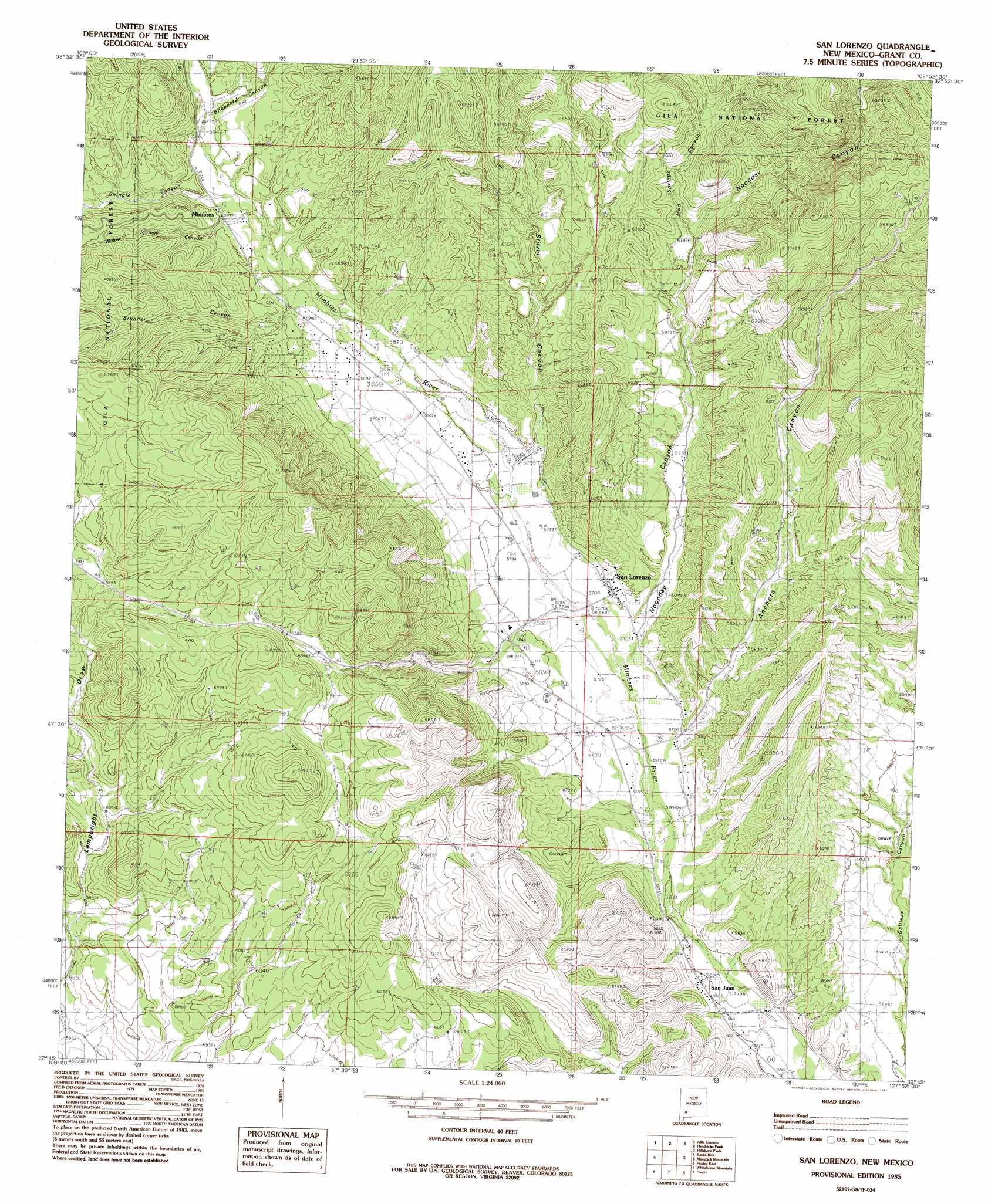
San Lorenzo Topo Map New Mexico
To zoom in, hover over the map of San Lorenzo
USGS Topo Quad 32107g8 - 1:24,000 scale
| Topo Map Name: | San Lorenzo |
| USGS Topo Quad ID: | 32107g8 |
| Print Size: | ca. 21 1/4" wide x 27" high |
| Southeast Coordinates: | 32.75° N latitude / 107.875° W longitude |
| Map Center Coordinates: | 32.8125° N latitude / 107.9375° W longitude |
| U.S. State: | NM |
| Filename: | o32107g8.jpg |
| Download Map JPG Image: | San Lorenzo topo map 1:24,000 scale |
| Map Type: | Topographic |
| Topo Series: | 7.5´ |
| Map Scale: | 1:24,000 |
| Source of Map Images: | United States Geological Survey (USGS) |
| Alternate Map Versions: |
San Lorenzo NM 1985, updated 1985 Download PDF Buy paper map San Lorenzo NM 1999, updated 2002 Download PDF Buy paper map San Lorenzo NM 2011 Download PDF Buy paper map San Lorenzo NM 2013 Download PDF Buy paper map |
| FStopo: | US Forest Service topo San Lorenzo is available: Download FStopo PDF Download FStopo TIF |
1:24,000 Topo Quads surrounding San Lorenzo
Copperas Peak |
North Star Mesa |
Hay Mesa |
Victoria Park |
Apache Peak |
Twin Sisters |
Allie Canyon |
Hendricks Peak |
Hillsboro Peak |
Kingston |
Fort Bayard |
Santa Rita |
San Lorenzo |
Maverick Mountain |
Pa Mountain |
Hurley West |
Hurley East |
Whitehorse Mountain |
Dwyer |
Whiterock Mountain |
Whitewater |
Faywood Station |
Taylor Mountain |
Faywood Se |
Ok Canyon |
> Back to 32107e1 at 1:100,000 scale
> Back to 32106a1 at 1:250,000 scale
> Back to U.S. Topo Maps home
San Lorenzo topo map: Gazetteer
San Lorenzo: Mines
Rose Mine elevation 1964m 6443′San Lorenzo: Populated Places
Mimbres elevation 1820m 5971′San Juan elevation 1712m 5616′
San Lorenzo elevation 1747m 5731′
San Lorenzo: Reservoirs
Beth Tank elevation 1938m 6358′Brunner Tank elevation 1925m 6315′
San Lorenzo: Valleys
Ancheta Canyon elevation 1734m 5688′Brunner Canyon elevation 1825m 5987′
Georgetown Canyon elevation 1828m 5997′
Mud Springs Canyon elevation 1861m 6105′
Noonday Canyon elevation 1757m 5764′
Sheppard Canyon elevation 1826m 5990′
Shingle Canyon elevation 1812m 5944′
Stitzel Canyon elevation 1757m 5764′
San Lorenzo: Wells
00017 Water Well elevation 1837m 6026′00028 Water Well elevation 1769m 5803′
00031 Water Well elevation 1753m 5751′
00042 Water Well elevation 1740m 5708′
00045 Water Well elevation 1739m 5705′
00048 Water Well elevation 1751m 5744′
00053 Water Well elevation 1736m 5695′
00056 Water Well elevation 1736m 5695′
00060 Water Well elevation 1735m 5692′
00064 Water Well elevation 1808m 5931′
00071 Water Well elevation 1798m 5898′
00073 Water Well elevation 1786m 5859′
00078 Water Well elevation 1795m 5889′
00080 Water Well elevation 1770m 5807′
00093 Water Well elevation 1920m 6299′
00096 Water Well elevation 1749m 5738′
00101 Water Well elevation 1746m 5728′
00276 Water Well elevation 1717m 5633′
00285 Water Well elevation 1713m 5620′
00286 Water Well elevation 1778m 5833′
00320 Water Well elevation 1889m 6197′
00321 Water Well elevation 1810m 5938′
01036 Water Well elevation 1726m 5662′
01069 Water Well elevation 1736m 5695′
10020 Water Well elevation 1778m 5833′
10167 Water Well elevation 1793m 5882′
10168 Water Well elevation 1782m 5846′
10169 Water Well elevation 1745m 5725′
10171 Water Well elevation 1849m 6066′
10172 Water Well elevation 1753m 5751′
10173 Water Well elevation 1847m 6059′
G 77 Water Well elevation 1755m 5757′
San Lorenzo digital topo map on disk
Buy this San Lorenzo topo map showing relief, roads, GPS coordinates and other geographical features, as a high-resolution digital map file on DVD: