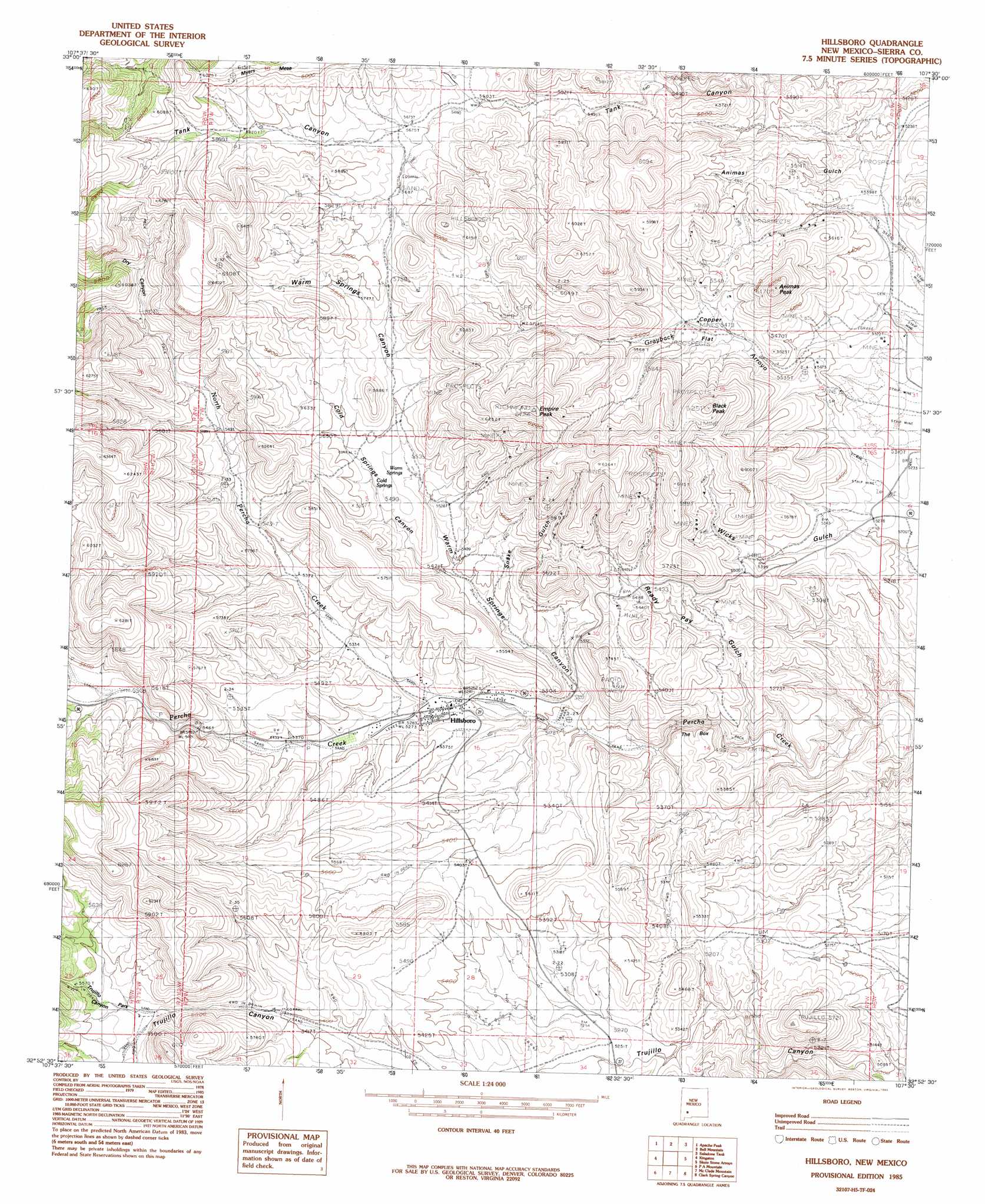
Hillsboro Topo Map New Mexico
To zoom in, hover over the map of Hillsboro
USGS Topo Quad 32107h5 - 1:24,000 scale
| Topo Map Name: | Hillsboro |
| USGS Topo Quad ID: | 32107h5 |
| Print Size: | ca. 21 1/4" wide x 27" high |
| Southeast Coordinates: | 32.875° N latitude / 107.5° W longitude |
| Map Center Coordinates: | 32.9375° N latitude / 107.5625° W longitude |
| U.S. State: | NM |
| Filename: | o32107h5.jpg |
| Download Map JPG Image: | Hillsboro topo map 1:24,000 scale |
| Map Type: | Topographic |
| Topo Series: | 7.5´ |
| Map Scale: | 1:24,000 |
| Source of Map Images: | United States Geological Survey (USGS) |
| Alternate Map Versions: |
Hillsboro NM 1985, updated 1985 Download PDF Buy paper map Hillsboro NM 1996, updated 2002 Download PDF Buy paper map Hillsboro NM 2010 Download PDF Buy paper map Hillsboro NM 2013 Download PDF Buy paper map |
1:24,000 Topo Quads surrounding Hillsboro
Reeds Peak |
Sugarloaf Peak |
Thumb Tank Peak |
Williamsburg Nw |
Cuchillo |
Victoria Park |
Apache Peak |
Bell Mountain |
Saladone Tank |
Williamsburg |
Hillsboro Peak |
Kingston |
Hillsboro |
Skute Stone Arroyo |
Caballo |
Maverick Mountain |
Pa Mountain |
Mcclede Mountain |
Clark Spring Canyon |
Garfield |
Dwyer |
Whiterock Mountain |
Lake Valley |
Jug Canyon |
Arroyo Cuervo |
> Back to 32107e1 at 1:100,000 scale
> Back to 32106a1 at 1:250,000 scale
> Back to U.S. Topo Maps home
Hillsboro topo map: Gazetteer
Hillsboro: Arroyos
Grayback Arroyo elevation 1611m 5285′Hillsboro: Flats
Copper Flat elevation 1675m 5495′Copper Flat elevation 1790m 5872′
Hillsboro: Mines
Bigelow elevation 1808m 5931′Black Peak elevation 1758m 5767′
Black Peak Mine elevation 1864m 6115′
Bonanza elevation 1884m 6181′
Buetecke Mine elevation 1708m 5603′
Bullion Mine elevation 1708m 5603′
Carrajel Shaft elevation 1814m 5951′
Chance Mine elevation 1665m 5462′
Cincinnati Mine elevation 1665m 5462′
Copper Flat Bulk Sample Plan Mine elevation 1685m 5528′
Copper Flat Mine elevation 1685m 5528′
Copper King Mine elevation 1676m 5498′
Crescent Lode Mine elevation 1719m 5639′
Dutch Gulch elevation 1623m 5324′
Eighty-Five Mine elevation 1791m 5875′
Empire elevation 1833m 6013′
Empire Mine elevation 1806m 5925′
Freidberg elevation 1663m 5456′
Fullerton elevation 1657m 5436′
Garfield-Butler elevation 1764m 5787′
Gold Dust Placers elevation 1595m 5232′
Golden Rule elevation 1669m 5475′
Hall Mine elevation 1524m 5000′
Hillsboro-Copper Flat elevation 1689m 5541′
Homestake Mine elevation 1692m 5551′
Jackpot Mine elevation 1826m 5990′
Katherine elevation 1816m 5958′
Little Wonder Mine elevation 1723m 5652′
Lost Arrowhead elevation 1585m 5200′
Luxemburg elevation 1650m 5413′
Mary Richmond elevation 1805m 5921′
McKinley Mine elevation 1714m 5623′
Morning Glory Mine elevation 1776m 5826′
National Defense elevation 1649m 5410′
National Defense Department Number One elevation 1610m 5282′
Opportunity elevation 1754m 5754′
Palma elevation 1597m 5239′
Palma Group elevation 1609m 5278′
Petroglyph Mine elevation 1674m 5492′
Quintana Incline elevation 1666m 5465′
Rattlesnake elevation 1763m 5784′
Rattlesnake Placers elevation 1658m 5439′
Ready Pay elevation 1793m 5882′
Republic Mine elevation 1723m 5652′
Sherman elevation 1831m 6007′
Stowaway Mine elevation 1773m 5816′
Sweetwater elevation 1648m 5406′
Tripp Mine elevation 1692m 5551′
Vanadinite Mine elevation 1554m 5098′
Virginia Claim elevation 1714m 5623′
Wicks elevation 1707m 5600′
Wisconsin Mine elevation 1723m 5652′
Hillsboro: Populated Places
Hillsboro elevation 1601m 5252′Hillsboro: Post Offices
Hillsboro Post Office elevation 1601m 5252′Hillsboro: Springs
Warm Springs elevation 1685m 5528′Hillsboro: Streams
North Percha Creek elevation 1609m 5278′Hillsboro: Summits
Animas Peak elevation 1868m 6128′Black Peak elevation 1893m 6210′
Empire Peak elevation 1953m 6407′
Hillsboro: Valleys
Cold Springs Canyon elevation 1640m 5380′Dry Canyon elevation 1710m 5610′
Ready Pay Gulch elevation 1535m 5036′
Sawpit Canyon elevation 1690m 5544′
Snake Gulch elevation 1637m 5370′
The Box elevation 1515m 4970′
Trujillo Park Canyon elevation 1677m 5501′
Warm Springs Canyon elevation 1585m 5200′
Hillsboro: Wells
27-100 3 Water Well elevation 1671m 5482′Hillsboro digital topo map on disk
Buy this Hillsboro topo map showing relief, roads, GPS coordinates and other geographical features, as a high-resolution digital map file on DVD: