Antelope Hill Topo Map New Mexico
To zoom in, hover over the map of Antelope Hill
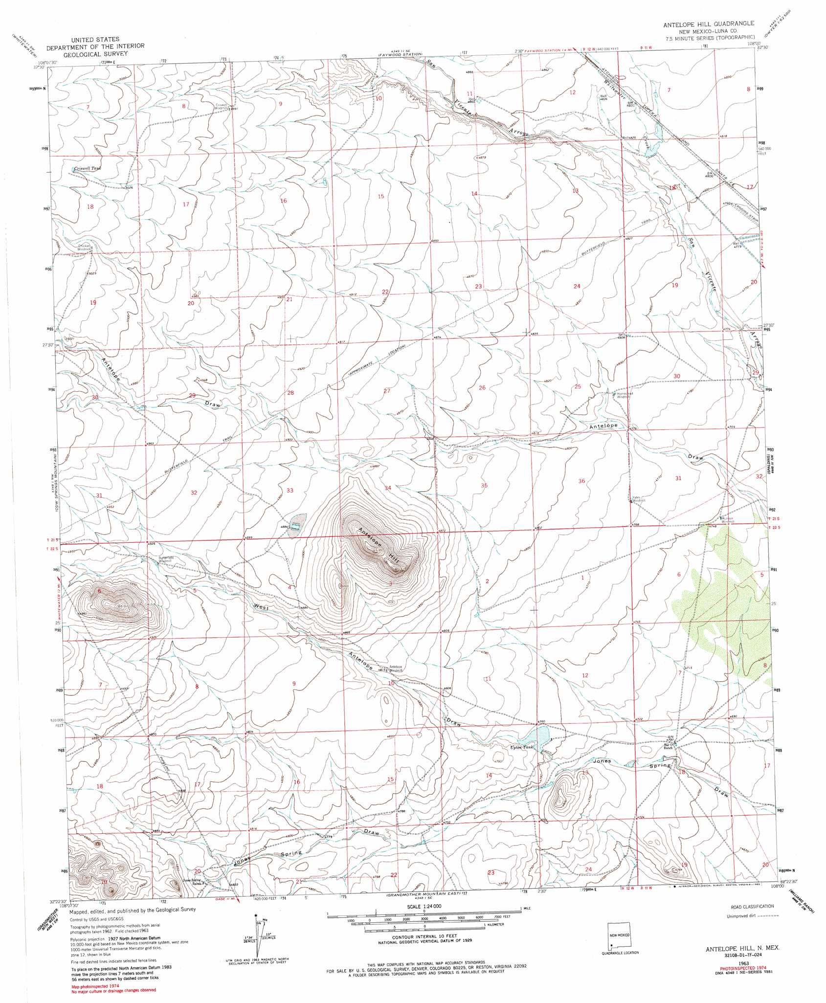
USGS Topo Quad 32108d1 - 1:24,000 scale
| Topo Map Name: | Antelope Hill |
| USGS Topo Quad ID: | 32108d1 |
| Print Size: | ca. 21 1/4" wide x 27" high |
| Southeast Coordinates: | 32.375° N latitude / 108° W longitude |
| Map Center Coordinates: | 32.4375° N latitude / 108.0625° W longitude |
| U.S. State: | NM |
| Filename: | o32108d1.jpg |
| Download Map JPG Image: | Antelope Hill topo map 1:24,000 scale |
| Map Type: | Topographic |
| Topo Series: | 7.5´ |
| Map Scale: | 1:24,000 |
| Source of Map Images: | United States Geological Survey (USGS) |
| Alternate Map Versions: |
Antelope Hill NM 1963, updated 1965 Download PDF Buy paper map Antelope Hill NM 1963, updated 1985 Download PDF Buy paper map Antelope Hill NM 2010 Download PDF Buy paper map Antelope Hill NM 2013 Download PDF Buy paper map Antelope Hill NM 2017 Download PDF Buy paper map |
1:24,000 Topo Quads surrounding Antelope Hill
Tyrone |
Hurley West |
Hurley East |
Whitehorse Mountain |
Dwyer |
White Signal |
Whitewater |
Faywood Station |
Taylor Mountain |
Faywood Se |
Werney Hill |
Cow Springs Mountain |
Antelope Hill |
Spalding |
Goat Ridge |
Soldiers Farewell Hill |
Grandmother Mountain West |
Grandmother Mountain East |
Williams Ranch |
Deming West |
Separ Ne |
Gage Nw |
Gage |
Red Mountain |
Bowlin Ranch |
> Back to 32108a1 at 1:100,000 scale
> Back to 32108a1 at 1:250,000 scale
> Back to U.S. Topo Maps home
Antelope Hill topo map: Gazetteer
Antelope Hill: Reservoirs
Criswell Tank elevation 1540m 5052′Upton Tank elevation 1448m 4750′
Antelope Hill: Streams
Whitewater Creek elevation 1452m 4763′Antelope Hill: Summits
Antelope Hill elevation 1578m 5177′Antelope Hill: Valleys
West Antelope Draw elevation 1442m 4730′Antelope Hill: Wells
01250 Water Well elevation 1435m 4708′01257 Water Well elevation 1496m 4908′
01258 Water Well elevation 1469m 4819′
01259 Water Well elevation 1449m 4753′
01267 Water Well elevation 1470m 4822′
01301 Water Well elevation 1466m 4809′
01302 Water Well elevation 1457m 4780′
01307 Water Well elevation 1456m 4776′
01319 Water Well elevation 1522m 4993′
01320 Water Well elevation 1483m 4865′
01321 Water Well elevation 1482m 4862′
01323 Water Well elevation 1482m 4862′
01324 Water Well elevation 1477m 4845′
01325 Water Well elevation 1475m 4839′
01326 Water Well elevation 1473m 4832′
01327 Water Well elevation 1485m 4872′
01328 Water Well elevation 1480m 4855′
01329 Water Well elevation 1477m 4845′
01330 Water Well elevation 1474m 4835′
01331 Water Well elevation 1519m 4983′
01333 Water Well elevation 1467m 4812′
01334 Water Well elevation 1464m 4803′
01335 Water Well elevation 1464m 4803′
01336 Water Well elevation 1446m 4744′
01471 Water Well elevation 1537m 5042′
06038 Water Well elevation 1501m 4924′
1260 Water Well elevation 1483m 4865′
Antelope Hill digital topo map on disk
Buy this Antelope Hill topo map showing relief, roads, GPS coordinates and other geographical features, as a high-resolution digital map file on DVD: