C Bar Ranch Topo Map New Mexico
To zoom in, hover over the map of C Bar Ranch
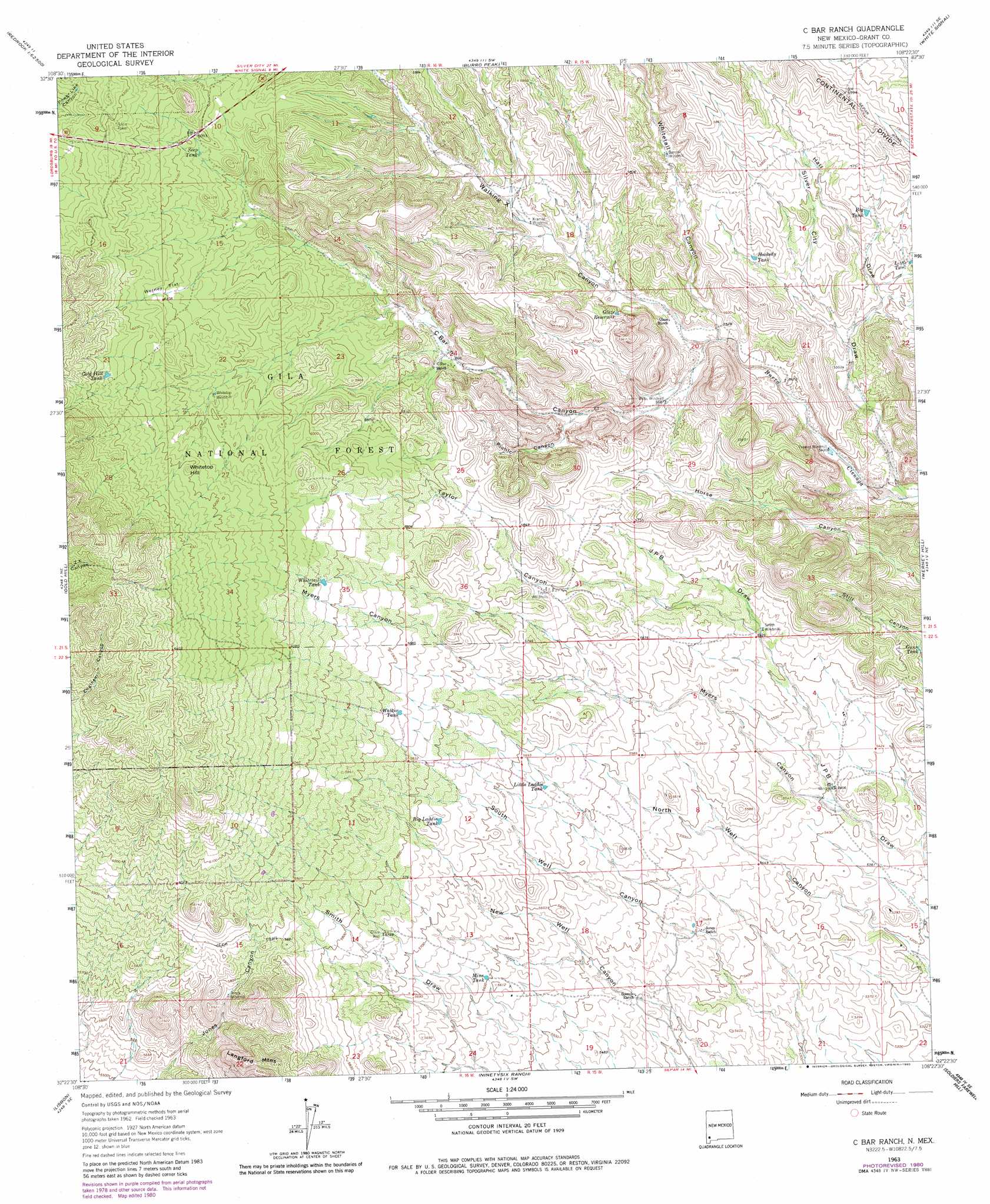
USGS Topo Quad 32108d4 - 1:24,000 scale
| Topo Map Name: | C Bar Ranch |
| USGS Topo Quad ID: | 32108d4 |
| Print Size: | ca. 21 1/4" wide x 27" high |
| Southeast Coordinates: | 32.375° N latitude / 108.375° W longitude |
| Map Center Coordinates: | 32.4375° N latitude / 108.4375° W longitude |
| U.S. State: | NM |
| Filename: | o32108d4.jpg |
| Download Map JPG Image: | C Bar Ranch topo map 1:24,000 scale |
| Map Type: | Topographic |
| Topo Series: | 7.5´ |
| Map Scale: | 1:24,000 |
| Source of Map Images: | United States Geological Survey (USGS) |
| Alternate Map Versions: |
C Bar Ranch NM 1963, updated 1966 Download PDF Buy paper map C Bar Ranch NM 1963, updated 1980 Download PDF Buy paper map C Bar Ranch NM 1999, updated 2002 Download PDF Buy paper map C Bar Ranch NM 2011 Download PDF Buy paper map C Bar Ranch NM 2013 Download PDF Buy paper map C Bar Ranch NM 2017 Download PDF Buy paper map |
| FStopo: | US Forest Service topo C Bar Ranch is available: Download FStopo PDF Download FStopo TIF |
1:24,000 Topo Quads surrounding C Bar Ranch
Redrock |
Bullard Peak |
Wind Mountain |
Tyrone |
Hurley West |
Willow Draw |
Eagle Eye Peak |
Burro Peak |
White Signal |
Whitewater |
Culberson Ranch |
Gold Hill |
C Bar Ranch |
Werney Hill |
Cow Springs Mountain |
Lordsburg |
Lisbon |
Ninetysix Ranch |
Soldiers Farewell Hill |
Grandmother Mountain West |
Pyramid Peak |
Muir Ranch |
Separ |
Separ Ne |
Gage Nw |
> Back to 32108a1 at 1:100,000 scale
> Back to 32108a1 at 1:250,000 scale
> Back to U.S. Topo Maps home
C Bar Ranch topo map: Gazetteer
C Bar Ranch: Flats
Werney Flat elevation 1860m 6102′C Bar Ranch: Mines
American Deposit elevation 1623m 5324′Double Strike Deposit elevation 1680m 5511′
C Bar Ranch: Reservoirs
Big Laddie Tank elevation 1757m 5764′Big Tank elevation 1729m 5672′
Blacktail Tank elevation 1841m 6040′
Burro Cienga Tank elevation 1659m 5442′
Glaze Reservoir elevation 1719m 5639′
Gold Hill Tank elevation 1908m 6259′
Gunn Tank elevation 1679m 5508′
Hookedy Tank elevation 1724m 5656′
Juniper Spring Tank elevation 1849m 6066′
Little Laddie Tank elevation 1721m 5646′
Little Tank elevation 1715m 5626′
Lonesome Tank elevation 1869m 6131′
Mine Tank elevation 1707m 5600′
Seep Tank elevation 1848m 6062′
Walker Tank elevation 1788m 5866′
Whitetail Tank elevation 1836m 6023′
C Bar Ranch: Summits
Whitetop Hill elevation 1909m 6263′C Bar Ranch: Valleys
C Bar Canyon elevation 1680m 5511′Hall Draw elevation 1686m 5531′
Myers Canyon elevation 1644m 5393′
Picnic Canyon elevation 1713m 5620′
Silver City Draw elevation 1643m 5390′
Taylor Canyon elevation 1686m 5531′
Walking X Canyon elevation 1680m 5511′
Whitetail Canyon elevation 1684m 5524′
C Bar Ranch: Wells
C Bar Water Well elevation 1802m 5912′Glaze Well elevation 1752m 5748′
Whitetop Well elevation 1841m 6040′
C Bar Ranch digital topo map on disk
Buy this C Bar Ranch topo map showing relief, roads, GPS coordinates and other geographical features, as a high-resolution digital map file on DVD: