Gold Hill Topo Map New Mexico
To zoom in, hover over the map of Gold Hill
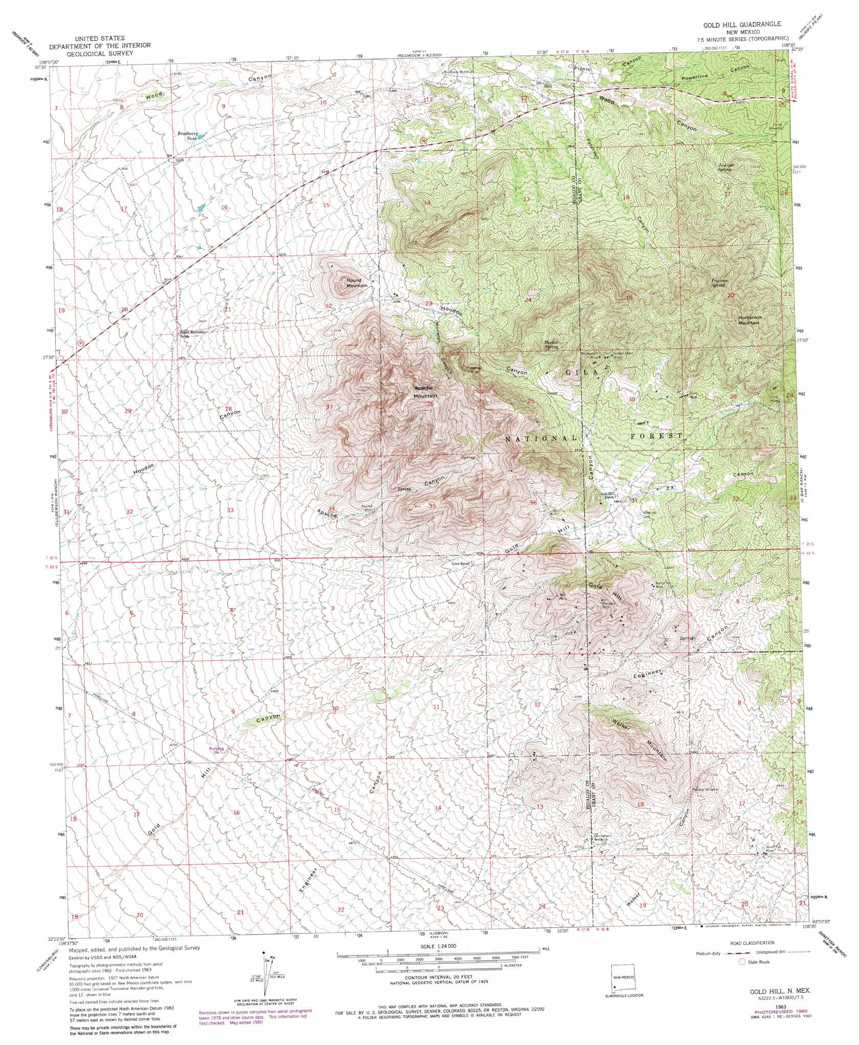
USGS Topo Quad 32108d5 - 1:24,000 scale
| Topo Map Name: | Gold Hill |
| USGS Topo Quad ID: | 32108d5 |
| Print Size: | ca. 21 1/4" wide x 27" high |
| Southeast Coordinates: | 32.375° N latitude / 108.5° W longitude |
| Map Center Coordinates: | 32.4375° N latitude / 108.5625° W longitude |
| U.S. State: | NM |
| Filename: | o32108d5.jpg |
| Download Map JPG Image: | Gold Hill topo map 1:24,000 scale |
| Map Type: | Topographic |
| Topo Series: | 7.5´ |
| Map Scale: | 1:24,000 |
| Source of Map Images: | United States Geological Survey (USGS) |
| Alternate Map Versions: |
Gold Hill NM 1963, updated 1965 Download PDF Buy paper map Gold Hill NM 1963, updated 1980 Download PDF Buy paper map Gold Hill NM 1999, updated 2002 Download PDF Buy paper map Gold Hill NM 2011 Download PDF Buy paper map Gold Hill NM 2013 Download PDF Buy paper map Gold Hill NM 2017 Download PDF Buy paper map |
| FStopo: | US Forest Service topo Gold Hill is available: Download FStopo PDF Download FStopo TIF |
1:24,000 Topo Quads surrounding Gold Hill
Nichols Canyon |
Redrock |
Bullard Peak |
Wind Mountain |
Tyrone |
Caprock Mountain |
Willow Draw |
Eagle Eye Peak |
Burro Peak |
White Signal |
Ninemile Hill |
Culberson Ranch |
Gold Hill |
C Bar Ranch |
Werney Hill |
Gary |
Lordsburg |
Lisbon |
Ninetysix Ranch |
Soldiers Farewell Hill |
Swallow Fork Peak |
Pyramid Peak |
Muir Ranch |
Separ |
Separ Ne |
> Back to 32108a1 at 1:100,000 scale
> Back to 32108a1 at 1:250,000 scale
> Back to U.S. Topo Maps home
Gold Hill topo map: Gazetteer
Gold Hill: Mines
Bruff Deposit elevation 1853m 6079′Contention Claim elevation 1777m 5830′
Coop Mine elevation 1990m 6528′
Crescent Deposit elevation 1839m 6033′
Golden Cross Mine elevation 1910m 6266′
Hughes elevation 1580m 5183′
Mill Mine elevation 1756m 5761′
Muscovy Mine elevation 1666m 5465′
Nancy Lee Mine elevation 1821m 5974′
Never Fail Mine elevation 1696m 5564′
Noonday Lode elevation 1773m 5816′
Orogrande elevation 1729m 5672′
Reservation Mine elevation 1947m 6387′
Ruby Mine elevation 1931m 6335′
Standard Mine elevation 1847m 6059′
Weatherfords Uranium Deposit elevation 1643m 5390′
Werney Mine elevation 1866m 6122′
White Rock Deposit elevation 1855m 6085′
Wing Feather Lady elevation 1886m 6187′
Gold Hill: Parks
McComas Incident Historical Marker elevation 1790m 5872′Gold Hill: Populated Places
Gold Hill (historical) elevation 1782m 5846′Gold Hill: Reservoirs
Apache Tank elevation 1805m 5921′Bradberry Tank elevation 1569m 5147′
Monarch Tank elevation 1758m 5767′
North Tank elevation 1711m 5613′
Oak Tank elevation 1824m 5984′
Peterson Tank elevation 1882m 6174′
Gold Hill: Springs
Hoodoo Spring elevation 1901m 6236′Juniper Spring elevation 1836m 6023′
Peterson Spring elevation 2008m 6587′
Gold Hill: Summits
Apache Mountain elevation 2114m 6935′Gold Hill elevation 1982m 6502′
Hornbrook Mountain elevation 2136m 7007′
Round Mountain elevation 1790m 5872′
Walker Mountain elevation 1897m 6223′
Gold Hill: Valleys
Monarch Canyon elevation 1725m 5659′Peterson Canyon elevation 1722m 5649′
Picnic Canyon elevation 1719m 5639′
Powerline Canyon elevation 1783m 5849′
Powerline Canyon elevation 1779m 5836′
Z X Canyon elevation 1775m 5823′
Gold Hill: Wells
Apache Wells elevation 1622m 5321′Gold Hill digital topo map on disk
Buy this Gold Hill topo map showing relief, roads, GPS coordinates and other geographical features, as a high-resolution digital map file on DVD: