Rock Tank Draw Topo Map New Mexico
To zoom in, hover over the map of Rock Tank Draw
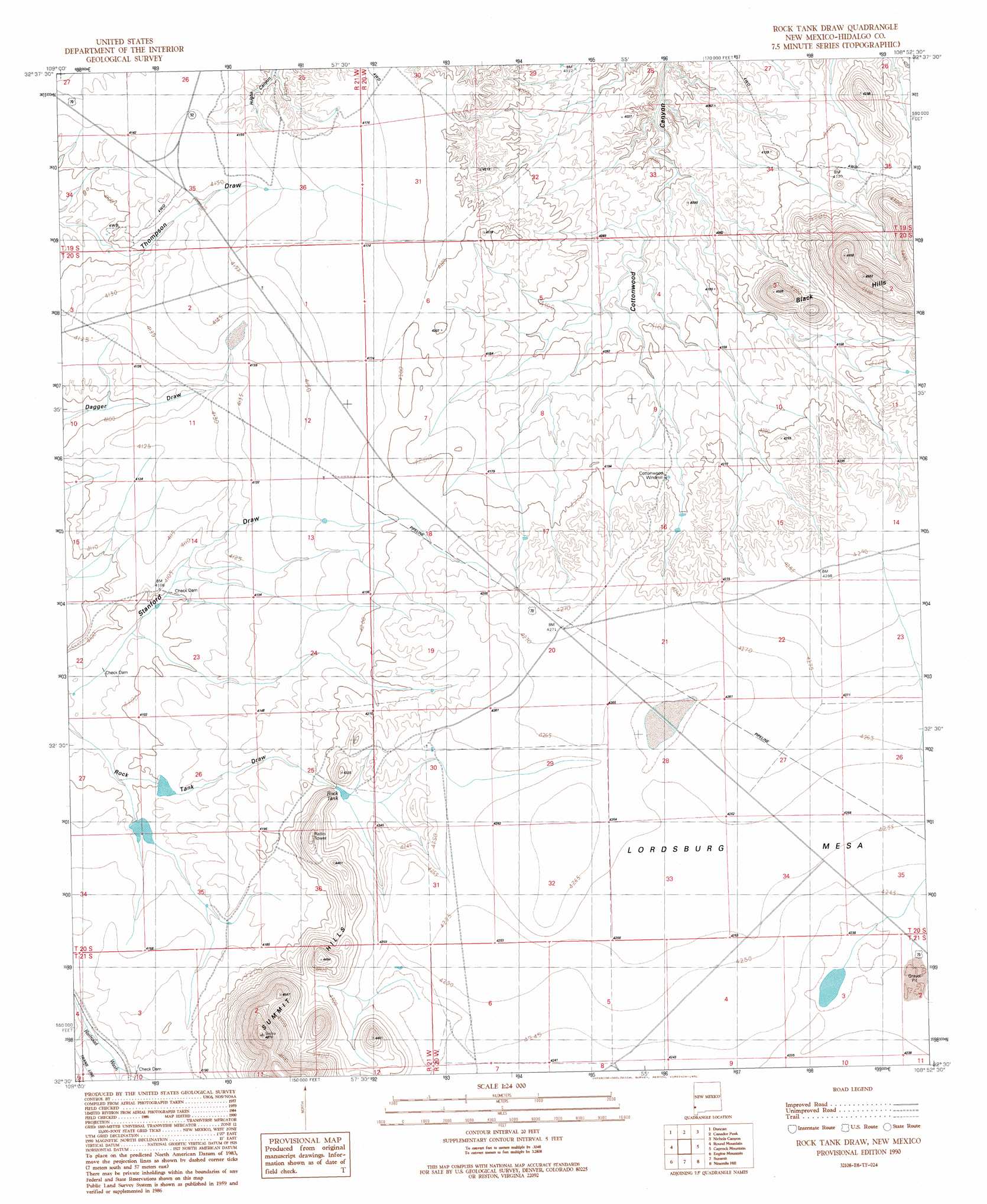
USGS Topo Quad 32108e8 - 1:24,000 scale
| Topo Map Name: | Rock Tank Draw |
| USGS Topo Quad ID: | 32108e8 |
| Print Size: | ca. 21 1/4" wide x 27" high |
| Southeast Coordinates: | 32.5° N latitude / 108.875° W longitude |
| Map Center Coordinates: | 32.5625° N latitude / 108.9375° W longitude |
| U.S. State: | NM |
| Filename: | o32108e8.jpg |
| Download Map JPG Image: | Rock Tank Draw topo map 1:24,000 scale |
| Map Type: | Topographic |
| Topo Series: | 7.5´ |
| Map Scale: | 1:24,000 |
| Source of Map Images: | United States Geological Survey (USGS) |
| Alternate Map Versions: |
Rock Tank Draw NM 1990, updated 1991 Download PDF Buy paper map Rock Tank Draw NM 2010 Download PDF Buy paper map Rock Tank Draw NM 2013 Download PDF Buy paper map Rock Tank Draw NM 2017 Download PDF Buy paper map |
1:24,000 Topo Quads surrounding Rock Tank Draw
Sheldon |
Goat Camp Spring |
Steeple Rock |
Walker Canyon |
Brushy Mountain |
Hot Well |
Duncan |
Canador Peak |
Nichols Canyon |
Redrock |
Whitlock Peak |
Round Mountain |
Rock Tank Draw |
Caprock Mountain |
Willow Draw |
Orange Butte |
Engine Mountain |
Summit |
Ninemile Hill |
Culberson Ranch |
San Simon |
Doubtful Mountain |
Mondel |
Gary |
Lordsburg |
> Back to 32108e1 at 1:100,000 scale
> Back to 32108a1 at 1:250,000 scale
> Back to U.S. Topo Maps home
Rock Tank Draw topo map: Gazetteer
Rock Tank Draw: Dams
Secho Detention Dam elevation 1269m 4163′Stanford Detention Dam Number Three elevation 1251m 4104′
Stanford Detention Dam Number Two elevation 1250m 4101′
Rock Tank Draw: Mines
Gila Bend elevation 1289m 4229′Rock Tank Draw: Ranges
Black Hills elevation 1393m 4570′Summit Hills elevation 1482m 4862′
Rock Tank Draw: Reservoirs
Rock Tank elevation 1281m 4202′Rock Tank Draw: Valleys
Rock Tank Draw elevation 1239m 4064′Rock Tank Draw digital topo map on disk
Buy this Rock Tank Draw topo map showing relief, roads, GPS coordinates and other geographical features, as a high-resolution digital map file on DVD: