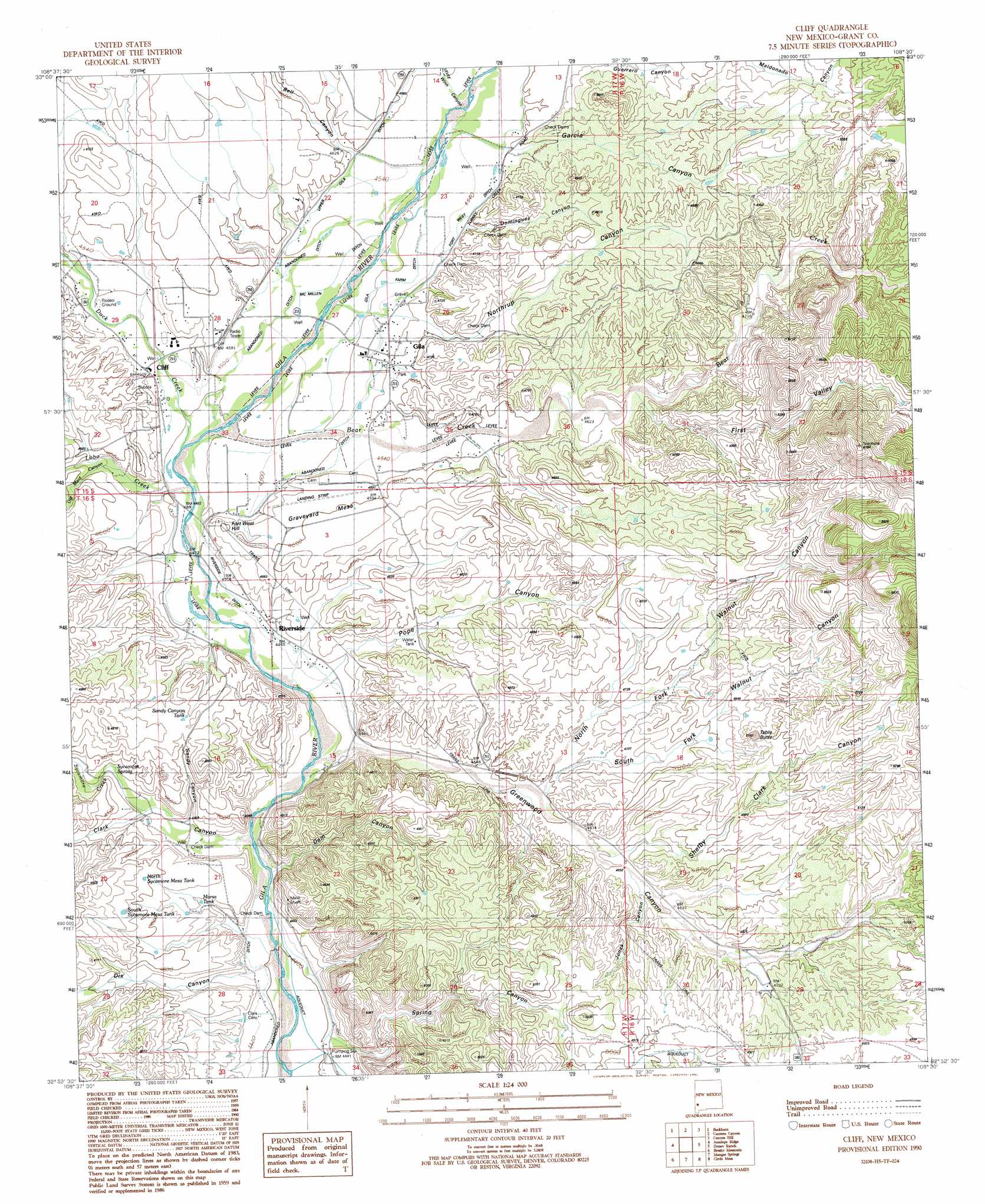
Cliff Topo Map New Mexico
To zoom in, hover over the map of Cliff
USGS Topo Quad 32108h5 - 1:24,000 scale
| Topo Map Name: | Cliff |
| USGS Topo Quad ID: | 32108h5 |
| Print Size: | ca. 21 1/4" wide x 27" high |
| Southeast Coordinates: | 32.875° N latitude / 108.5° W longitude |
| Map Center Coordinates: | 32.9375° N latitude / 108.5625° W longitude |
| U.S. State: | NM |
| Filename: | o32108h5.jpg |
| Download Map JPG Image: | Cliff topo map 1:24,000 scale |
| Map Type: | Topographic |
| Topo Series: | 7.5´ |
| Map Scale: | 1:24,000 |
| Source of Map Images: | United States Geological Survey (USGS) |
| Alternate Map Versions: |
Cliff NM 1990, updated 1991 Download PDF Buy paper map Cliff NM 2010 Download PDF Buy paper map Cliff NM 2013 Download PDF Buy paper map Cliff NM 2017 Download PDF Buy paper map |
1:24,000 Topo Quads surrounding Cliff
Moon Ranch |
Rice Ranch |
Shelley Peak |
Diablo Range |
Little Turkey Park |
Bear Mountain |
Buckhorn |
Canteen Canyon |
Canyon Hill |
Granny Mountain |
Applegate Mountain |
Antelope Ridge |
Cliff |
Dorsey Ranch |
Reading Mountain |
Walker Canyon |
Brushy Mountain |
Mangas Springs |
Circle Mesa |
Silver City |
Nichols Canyon |
Redrock |
Bullard Peak |
Wind Mountain |
Tyrone |
> Back to 32108e1 at 1:100,000 scale
> Back to 32108a1 at 1:250,000 scale
> Back to U.S. Topo Maps home
Cliff topo map: Gazetteer
Cliff: Canals
Clark Ditch elevation 1347m 4419′Crawford-De Forest Ditch elevation 1350m 4429′
Fort West Ditch elevation 1403m 4603′
Gila Farm Ditch elevation 1380m 4527′
McMillen Ditch elevation 1372m 4501′
Riverside Ditch elevation 1363m 4471′
Slayback Ditch elevation 1375m 4511′
Upper Gila Ditch elevation 1398m 4586′
Cliff: Dams
Upper Gila Site Number Four Dam elevation 1410m 4625′Upper Gila Site Number One Dam elevation 1408m 4619′
Upper Gila Site Three Dam elevation 1400m 4593′
Upper Gila Valley Site Number 12 Dam elevation 1381m 4530′
Cliff: Lakes
North Sycamore Mesa Tank elevation 1400m 4593′Cliff: Mines
Hillside elevation 1451m 4760′Cliff: Populated Places
Cliff elevation 1371m 4498′Gila elevation 1389m 4557′
Riverside elevation 1366m 4481′
Cliff: Post Offices
Cliff Post Office elevation 1371m 4498′Cliff: Reservoirs
Marsa Tank elevation 1369m 4491′Sandy Canyon Tank elevation 1422m 4665′
South Sycamore Mesa Tank elevation 1415m 4642′
Cliff: Springs
Sycamore Spring elevation 1379m 4524′Cliff: Streams
Bear Creek elevation 1367m 4484′Duck Creek elevation 1365m 4478′
Lobo Creek elevation 1361m 4465′
Sycamore Creek elevation 1362m 4468′
Cliff: Summits
Fort West Hill elevation 1400m 4593′Graveyard Mesa elevation 1404m 4606′
Table Butte elevation 1548m 5078′
Cliff: Valleys
Bell Canyon elevation 1384m 4540′Clark Canyon elevation 1348m 4422′
Dam Canyon elevation 1351m 4432′
Dix Canyon elevation 1347m 4419′
Domingues Canyon elevation 1404m 4606′
First Valley elevation 1440m 4724′
Garcia Canyon elevation 1393m 4570′
Greenwood Canyon elevation 1360m 4461′
Jones Canyon elevation 1425m 4675′
North Fork Walnut Canyon elevation 1398m 4586′
Northrup Canyon elevation 1394m 4573′
Pope Canyon elevation 1365m 4478′
Sandy Canyon elevation 1374m 4507′
Shelby Clark Canyon elevation 1420m 4658′
South Fork Walnut Canyon elevation 1408m 4619′
Spring Canyon elevation 1360m 4461′
Winn Canyon elevation 1385m 4543′
Cliff digital topo map on disk
Buy this Cliff topo map showing relief, roads, GPS coordinates and other geographical features, as a high-resolution digital map file on DVD: