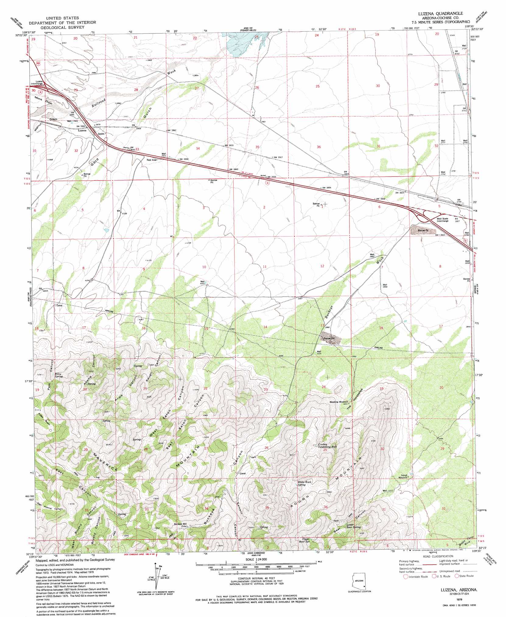
Luzena Topo Map Arizona
To zoom in, hover over the map of Luzena
USGS Topo Quad 32109c5 - 1:24,000 scale
| Topo Map Name: | Luzena |
| USGS Topo Quad ID: | 32109c5 |
| Print Size: | ca. 21 1/4" wide x 27" high |
| Southeast Coordinates: | 32.25° N latitude / 109.5° W longitude |
| Map Center Coordinates: | 32.3125° N latitude / 109.5625° W longitude |
| U.S. State: | AZ |
| Filename: | o32109c5.jpg |
| Download Map JPG Image: | Luzena topo map 1:24,000 scale |
| Map Type: | Topographic |
| Topo Series: | 7.5´ |
| Map Scale: | 1:24,000 |
| Source of Map Images: | United States Geological Survey (USGS) |
| Alternate Map Versions: |
Luzena AZ 1979, updated 1979 Download PDF Buy paper map Luzena AZ 1979, updated 1992 Download PDF Buy paper map Luzena AZ 1996, updated 2002 Download PDF Buy paper map Luzena AZ 2011 Download PDF Buy paper map Luzena AZ 2014 Download PDF Buy paper map |
1:24,000 Topo Quads surrounding Luzena
Stockton Pass |
Gillespie Mountain |
Tanque |
Javelina Peak |
Whitlock Cienega |
Greasewood Mountain |
Monk Draw |
Fisher Hills |
Ryan Draw |
Martin Well |
Willcox North |
Railroad Pass |
Luzena |
Bowie |
Olga |
Willcox South |
Simmons Peak |
Dos Cabezas |
Bowie Mountain North |
Little Wood Canyon |
Sulphur Spring |
Dos Cabezas Sw |
Pat Hills North |
Bowie Mountain South |
Cochise Head |
> Back to 32109a1 at 1:100,000 scale
> Back to 32108a1 at 1:250,000 scale
> Back to U.S. Topo Maps home
Luzena topo map: Gazetteer
Luzena: Basins
Fuller Basin elevation 1588m 5209′The Horseshoe elevation 1232m 4041′
Luzena: Crossings
Luzena Interchange elevation 1232m 4041′West Bowie Interchange elevation 1171m 3841′
Luzena: Mines
Buckeye Apache Mine elevation 1526m 5006′Luzena: Populated Places
Buckeye Mill elevation 1469m 4819′Luzena: Springs
Cowboy Swimming Hole elevation 1459m 4786′Lower Bear Spring elevation 1499m 4917′
Riley Spring elevation 1436m 4711′
Upper Bear Spring elevation 1663m 5456′
White Rock Spring elevation 1746m 5728′
Luzena: Streams
Buckeye Wash elevation 1155m 3789′Railroad Wash elevation 1174m 3851′
Luzena: Summits
Maverick Mountain elevation 1856m 6089′Luzena: Valleys
Adams Canyon elevation 1315m 4314′Angle Canyon elevation 1307m 4288′
Bear Canyon elevation 1280m 4199′
Brushy Canyon elevation 1540m 5052′
Buckeye Canyon elevation 1261m 4137′
Cement Canyon elevation 1359m 4458′
East Eaton Canyon elevation 1266m 4153′
Monk Draw elevation 1214m 3982′
Park Canyon elevation 1316m 4317′
Rough Canyon elevation 1281m 4202′
Walnut Gulch elevation 1214m 3982′
West Brushy Canyon elevation 1550m 5085′
West Eaton Canyon elevation 1277m 4189′
Luzena: Wells
CCC Camp Well elevation 1311m 4301′Luzena digital topo map on disk
Buy this Luzena topo map showing relief, roads, GPS coordinates and other geographical features, as a high-resolution digital map file on DVD: