Safford Topo Map Arizona
To zoom in, hover over the map of Safford
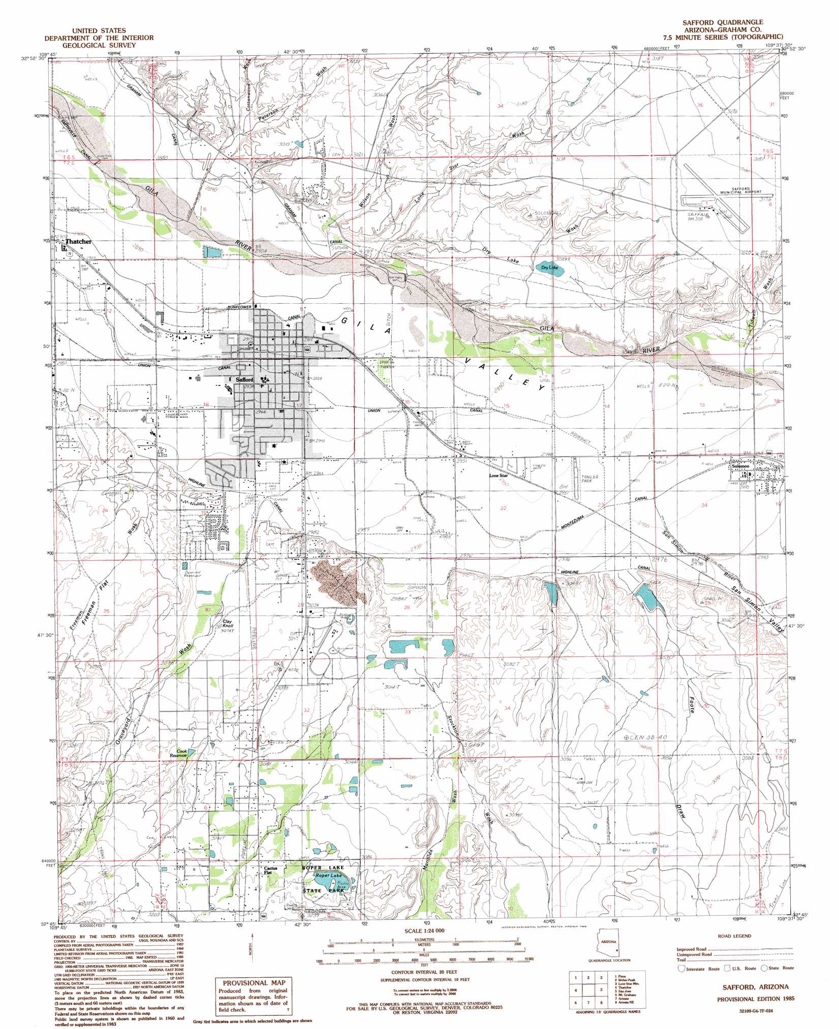
USGS Topo Quad 32109g6 - 1:24,000 scale
| Topo Map Name: | Safford |
| USGS Topo Quad ID: | 32109g6 |
| Print Size: | ca. 21 1/4" wide x 27" high |
| Southeast Coordinates: | 32.75° N latitude / 109.625° W longitude |
| Map Center Coordinates: | 32.8125° N latitude / 109.6875° W longitude |
| U.S. State: | AZ |
| Filename: | o32109g6.jpg |
| Download Map JPG Image: | Safford topo map 1:24,000 scale |
| Map Type: | Topographic |
| Topo Series: | 7.5´ |
| Map Scale: | 1:24,000 |
| Source of Map Images: | United States Geological Survey (USGS) |
| Alternate Map Versions: |
Safford AZ 1985, updated 1986 Download PDF Buy paper map Safford AZ 1985, updated 1986 Download PDF Buy paper map Safford AZ 2011 Download PDF Buy paper map Safford AZ 2014 Download PDF Buy paper map |
1:24,000 Topo Quads surrounding Safford
Fort Thomas |
Markham Creek |
Bryce Mountain |
Bonita Spring |
Copperplate Gulch |
Eden |
Pima |
Weber Peak |
Lone Star Mountain |
Gila Box |
Shingle Mill Mountain |
Thatcher |
Safford |
San Jose |
Tollgate Tank |
Webb Peak |
Mount Graham |
Artesia |
Artesia Ne |
Dry Mountain |
Fort Grant |
Stockton Pass |
Gillespie Mountain |
Tanque |
Javelina Peak |
> Back to 32109e1 at 1:100,000 scale
> Back to 32108a1 at 1:250,000 scale
> Back to U.S. Topo Maps home
Safford topo map: Gazetteer
Safford: Airports
High Mesa Airpark elevation 941m 3087′Safford Municipal Airport elevation 967m 3172′
Safford: Canals
Highline Canal elevation 908m 2979′Montezuma Canal elevation 904m 2965′
Sunflower Canal elevation 887m 2910′
Union Canal elevation 896m 2939′
Safford: Dams
Cactus Dam elevation 954m 3129′Foote Wash Dam elevation 935m 3067′
Freeman Wash Retarding Dam elevation 909m 2982′
Graveyard Wash Retarding Dam elevation 921m 3021′
No Name Wash Dam elevation 926m 3038′
Roper Dam elevation 955m 3133′
Smith Detention Dam elevation 917m 3008′
Stockton Pass Dam elevation 939m 3080′
Stockton Wash Retarding Dam elevation 920m 3018′
Safford: Flats
Freeman Flat elevation 930m 3051′Safford: Lakes
Roper Lake elevation 955m 3133′Safford: Populated Places
Cactus Flat elevation 954m 3129′Hollywood elevation 890m 2919′
Lone Star elevation 900m 2952′
Safford elevation 0m 0′
Solomon elevation 906m 2972′
Safford: Post Offices
Safford Post Office elevation 889m 2916′Solomon Post Office elevation 906m 2972′
Safford: Reservoirs
Cook Reservoir elevation 953m 3126′Dry Lake elevation 927m 3041′
Safford: Streams
Cottonwood Wash elevation 898m 2946′Dry Lake Wash elevation 887m 2910′
Freeman Wash elevation 907m 2975′
Graveyard Wash elevation 902m 2959′
Lone Star Wash elevation 884m 2900′
Marijilda Wash elevation 921m 3021′
Marijilda Wash elevation 921m 3021′
Peterson Wash elevation 891m 2923′
San Simon River elevation 897m 2942′
Stockton Wash elevation 908m 2979′
Tidwell Wash elevation 902m 2959′
Wilson Wash elevation 884m 2900′
Safford: Summits
Clay Knoll elevation 927m 3041′Safford: Valleys
Foote Draw elevation 913m 2995′San Simon Valley elevation 0m 0′
Safford digital topo map on disk
Buy this Safford topo map showing relief, roads, GPS coordinates and other geographical features, as a high-resolution digital map file on DVD: