Lone Star Mountain Topo Map Arizona
To zoom in, hover over the map of Lone Star Mountain
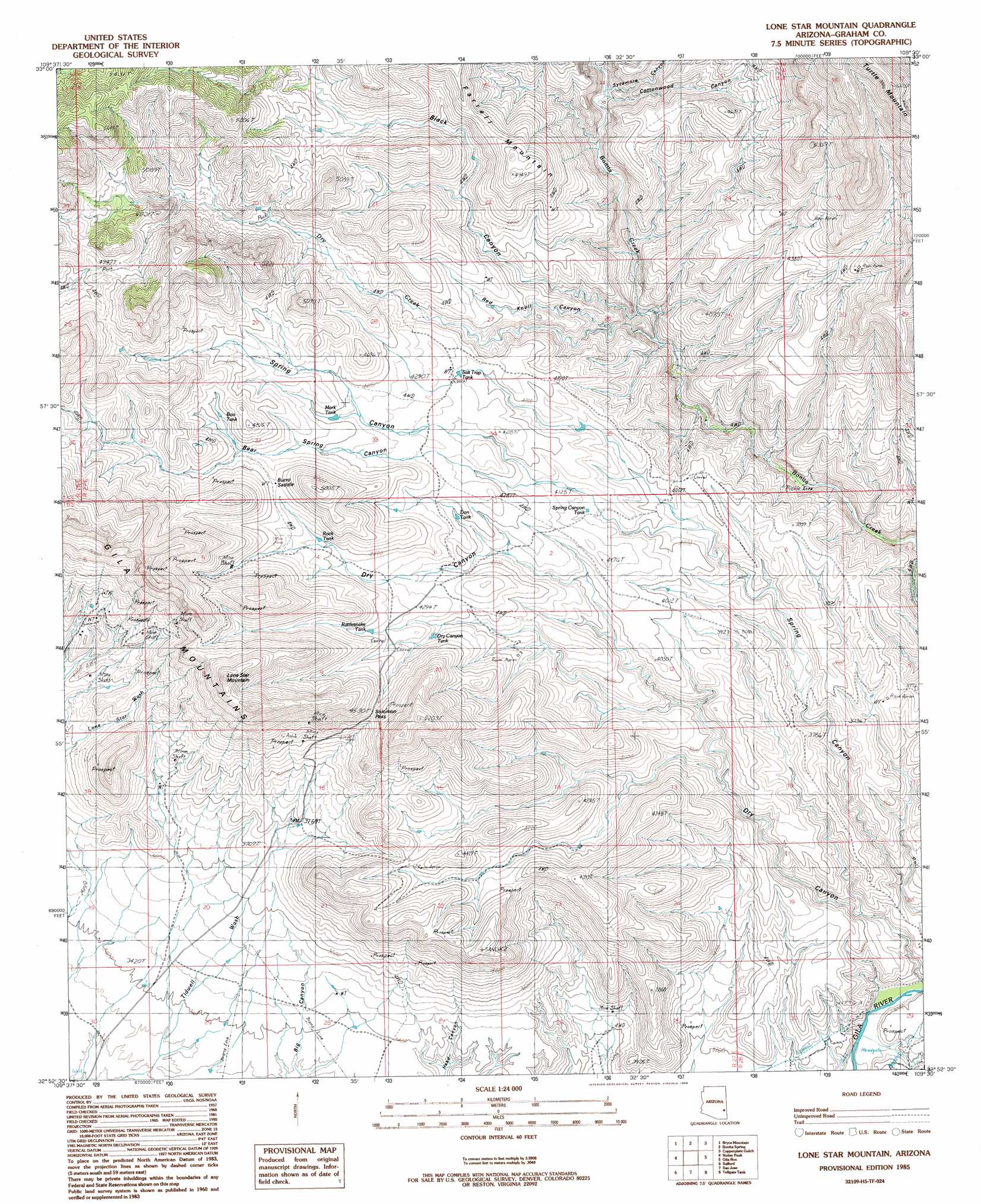
USGS Topo Quad 32109h5 - 1:24,000 scale
| Topo Map Name: | Lone Star Mountain |
| USGS Topo Quad ID: | 32109h5 |
| Print Size: | ca. 21 1/4" wide x 27" high |
| Southeast Coordinates: | 32.875° N latitude / 109.5° W longitude |
| Map Center Coordinates: | 32.9375° N latitude / 109.5625° W longitude |
| U.S. State: | AZ |
| Filename: | o32109h5.jpg |
| Download Map JPG Image: | Lone Star Mountain topo map 1:24,000 scale |
| Map Type: | Topographic |
| Topo Series: | 7.5´ |
| Map Scale: | 1:24,000 |
| Source of Map Images: | United States Geological Survey (USGS) |
| Alternate Map Versions: |
Lone Star Mountain AZ 1985, updated 1986 Download PDF Buy paper map Lone Star Mountain AZ 1985, updated 1986 Download PDF Buy paper map Lone Star Mountain AZ 2011 Download PDF Buy paper map Lone Star Mountain AZ 2014 Download PDF Buy paper map |
1:24,000 Topo Quads surrounding Lone Star Mountain
Bonita Tank |
Park Creek Cabins |
Elevator Mountain |
Coronado Mountain |
Mitchell Peak |
Markham Creek |
Bryce Mountain |
Bonita Spring |
Copperplate Gulch |
Clifton |
Pima |
Weber Peak |
Lone Star Mountain |
Gila Box |
Guthrie |
Thatcher |
Safford |
San Jose |
Tollgate Tank |
Ash Peak |
Mount Graham |
Artesia |
Artesia Ne |
Dry Mountain |
Whitlock Mountains Ne |
> Back to 32109e1 at 1:100,000 scale
> Back to 32108a1 at 1:250,000 scale
> Back to U.S. Topo Maps home
Lone Star Mountain topo map: Gazetteer
Lone Star Mountain: Gaps
Burro Saddle elevation 1395m 4576′Solomon Pass elevation 1375m 4511′
Lone Star Mountain: Mines
Horseshoe Mine elevation 1204m 3950′Lone Star Mine elevation 1214m 3982′
Lone Star Mountain: Reservoirs
Boo Tank elevation 1390m 4560′Don Tank elevation 1278m 4192′
Dry Canyon Tank elevation 1291m 4235′
Mark Tank elevation 1338m 4389′
Rattlesnake Tank elevation 1329m 4360′
Rock Tank elevation 1343m 4406′
Salt Trap Tank elevation 0m 0′
Spring Canyon Tank elevation 1234m 4048′
Lone Star Mountain: Springs
Cottonwood Spring elevation 1317m 4320′Dry Canyon Spring elevation 1416m 4645′
Red Tanks Spring elevation 1380m 4527′
Lone Star Mountain: Streams
Dry Creek elevation 1081m 3546′Lone Star Mountain: Summits
Lone Star Mountain elevation 1645m 5396′Lone Star Mountain: Valleys
Bear Spring Canyon elevation 1255m 4117′Black Canyon elevation 1155m 3789′
Cottonwood Canyon elevation 1189m 3900′
Dry Canyon elevation 967m 3172′
Red Knoll Canyon elevation 1154m 3786′
Sycamore Canyon elevation 1148m 3766′
Lone Star Mountain digital topo map on disk
Buy this Lone Star Mountain topo map showing relief, roads, GPS coordinates and other geographical features, as a high-resolution digital map file on DVD: