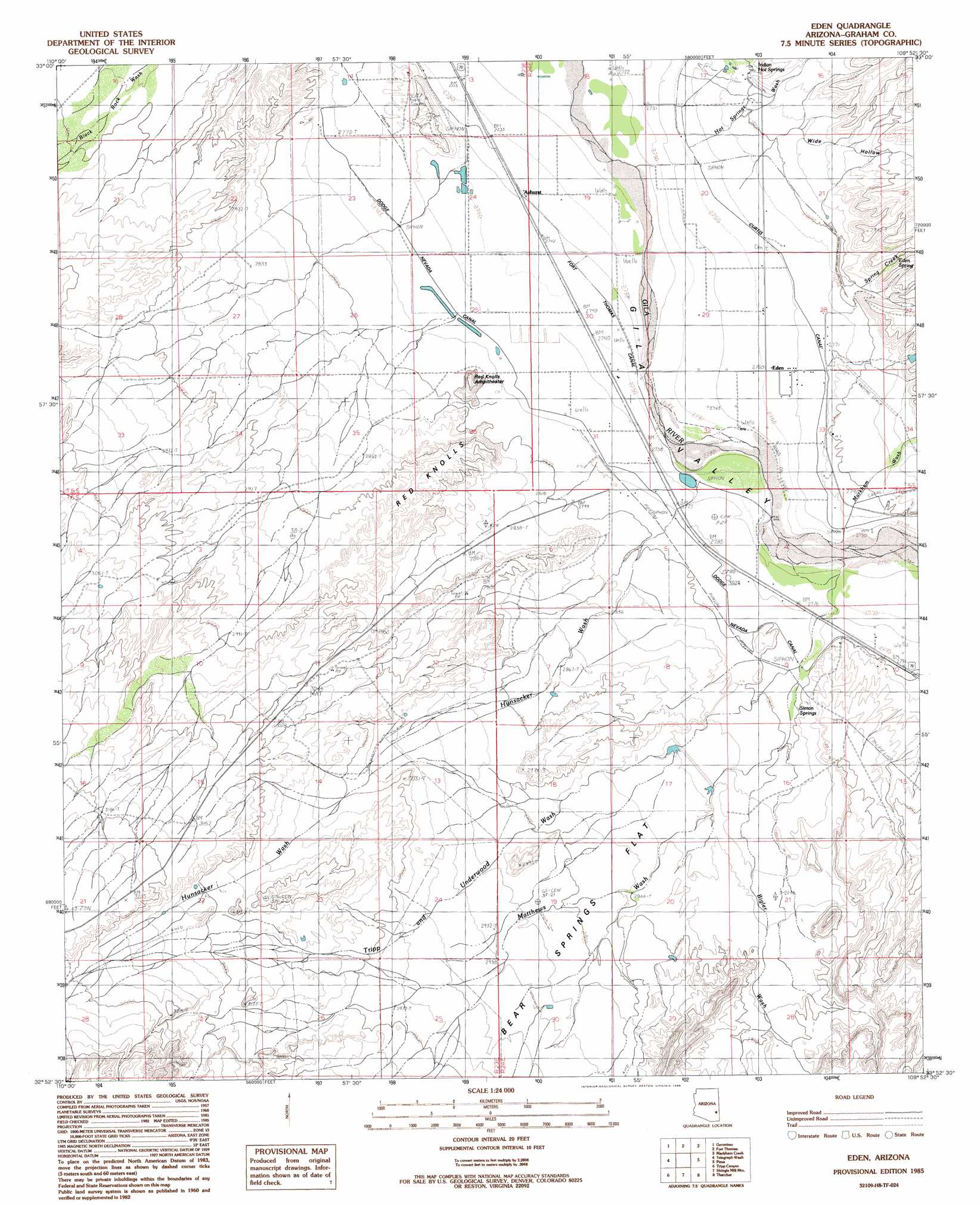
Eden Topo Map Arizona
To zoom in, hover over the map of Eden
USGS Topo Quad 32109h8 - 1:24,000 scale
| Topo Map Name: | Eden |
| USGS Topo Quad ID: | 32109h8 |
| Print Size: | ca. 21 1/4" wide x 27" high |
| Southeast Coordinates: | 32.875° N latitude / 109.875° W longitude |
| Map Center Coordinates: | 32.9375° N latitude / 109.9375° W longitude |
| U.S. State: | AZ |
| Filename: | o32109h8.jpg |
| Download Map JPG Image: | Eden topo map 1:24,000 scale |
| Map Type: | Topographic |
| Topo Series: | 7.5´ |
| Map Scale: | 1:24,000 |
| Source of Map Images: | United States Geological Survey (USGS) |
| Alternate Map Versions: |
Eden AZ 1985, updated 1986 Download PDF Buy paper map Eden AZ 2011 Download PDF Buy paper map Eden AZ 2014 Download PDF Buy paper map |
1:24,000 Topo Quads surrounding Eden
Calva |
Bylas |
Gila Peak |
Bonita Tank |
Park Creek Cabins |
Beargrass Basin |
Geronimo |
Fort Thomas |
Markham Creek |
Bryce Mountain |
Jackson Mountain |
Telegraph Wash |
Eden |
Pima |
Weber Peak |
Buford Hill |
Tripp Canyon |
Shingle Mill Mountain |
Thatcher |
Safford |
Eureka Ranch |
Blue Jay Peak |
Webb Peak |
Mount Graham |
Artesia |
> Back to 32109e1 at 1:100,000 scale
> Back to 32108a1 at 1:250,000 scale
> Back to U.S. Topo Maps home
Eden topo map: Gazetteer
Eden: Basins
Red Knolls Amphitheater elevation 854m 2801′Eden: Canals
Battle Creek Canal elevation 837m 2746′Curtis Canal elevation 844m 2769′
Dodge Nevada Canal elevation 848m 2782′
Eden: Dams
Oso Largo Dike Dam elevation 866m 2841′Eden: Flats
Bear Springs Flat elevation 893m 2929′Eden: Populated Places
Ashurst elevation 835m 2739′Cork elevation 842m 2762′
Eden elevation 840m 2755′
Indian Hot Springs elevation 851m 2791′
Eden: Post Offices
Eden Post Office elevation 841m 2759′Eden: Reservoirs
Biglers Reservoir elevation 876m 2874′Eldon Palmer Reservoir elevation 876m 2874′
Quarry Reservoir elevation 872m 2860′
Eden: Springs
Beauty Springs elevation 855m 2805′Eden Spring elevation 874m 2867′
Indian Hot Springs elevation 856m 2808′
Iron Springs elevation 857m 2811′
Magnesium Springs elevation 856m 2808′
Mud Springs elevation 860m 2821′
Simon Springs elevation 853m 2798′
Eden: Streams
Bigler Wash elevation 854m 2801′Hot Springs Wash elevation 839m 2752′
Hunsacker Wash elevation 836m 2742′
Markham Wash elevation 838m 2749′
Matthews Wash elevation 840m 2755′
Spring Creek elevation 845m 2772′
Tripp and Underwood Wash elevation 850m 2788′
Eden: Summits
Red Knolls elevation 872m 2860′Eden: Valleys
Wide Hollow elevation 842m 2762′Eden: Wells
Gila Well elevation 837m 2746′Eden digital topo map on disk
Buy this Eden topo map showing relief, roads, GPS coordinates and other geographical features, as a high-resolution digital map file on DVD: