Rincon Peak Topo Map Arizona
To zoom in, hover over the map of Rincon Peak
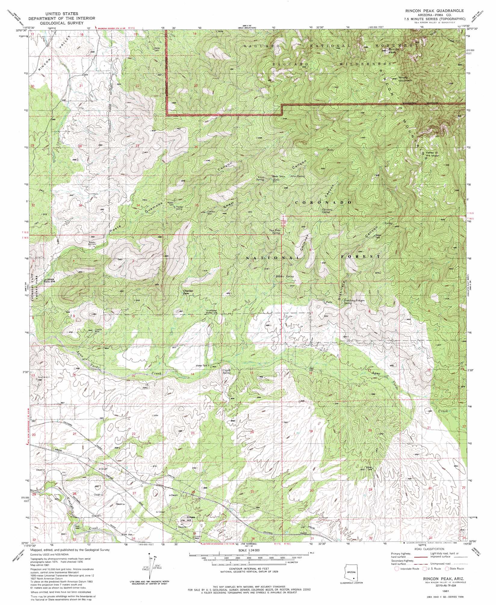
USGS Topo Quad 32110a5 - 1:24,000 scale
| Topo Map Name: | Rincon Peak |
| USGS Topo Quad ID: | 32110a5 |
| Print Size: | ca. 21 1/4" wide x 27" high |
| Southeast Coordinates: | 32° N latitude / 110.5° W longitude |
| Map Center Coordinates: | 32.0625° N latitude / 110.5625° W longitude |
| U.S. State: | AZ |
| Filename: | o32110a5.jpg |
| Download Map JPG Image: | Rincon Peak topo map 1:24,000 scale |
| Map Type: | Topographic |
| Topo Series: | 7.5´ |
| Map Scale: | 1:24,000 |
| Source of Map Images: | United States Geological Survey (USGS) |
| Alternate Map Versions: |
Rincon Peak AZ 1981, updated 1981 Download PDF Buy paper map Rincon Peak AZ 1981, updated 1986 Download PDF Buy paper map Rincon Peak AZ 1981, updated 1986 Download PDF Buy paper map Rincon Peak AZ 1996, updated 2002 Download PDF Buy paper map Rincon Peak AZ 2011 Download PDF Buy paper map Rincon Peak AZ 2014 Download PDF Buy paper map |
| FStopo: | US Forest Service topo Rincon Peak is available: Download FStopo PDF Download FStopo TIF |
1:24,000 Topo Quads surrounding Rincon Peak
Sabino Canyon |
Agua Caliente Hill |
Piety Hill |
Soza Canyon |
Soza Mesa |
Tucson East |
Tanque Verde Peak |
Mica Mountain |
Happy Valley |
Wildhorse Mountain |
Tucson Se |
Vail |
Rincon Peak |
Galleta Flat West |
Galleta Flat East |
Corona De Tucson |
Mount Fagan |
The Narrows |
Mescal |
Benson |
Helvetia |
Empire Ranch |
Spring Water Canyon |
Apache Peak |
Mcgrew Spring |
> Back to 32110a1 at 1:100,000 scale
> Back to 32110a1 at 1:250,000 scale
> Back to U.S. Topo Maps home
Rincon Peak topo map: Gazetteer
Rincon Peak: Basins
Valley of the Moon elevation 2114m 6935′Rincon Peak: Dams
Charlies Dam elevation 1150m 3772′Rincon Peak: Parks
La Sevilla Picnic Area elevation 1078m 3536′Rincon Peak: Populated Places
Harrington Place elevation 1137m 3730′Rincon Peak: Reservoirs
Arrowhead Water Tank elevation 1146m 3759′Rincon Peak: Springs
Aliso Spring elevation 1675m 5495′Bear Wallow Spring elevation 2365m 7759′
CCC Spring elevation 1111m 3645′
Chimney Spring elevation 1556m 5104′
Coyote Spring elevation 1129m 3704′
Distillery Canyon Spring elevation 1280m 4199′
Grapevine Spring elevation 1627m 5337′
Hidden Spring elevation 1216m 3989′
Lion Spring elevation 1566m 5137′
Papago Spring elevation 1192m 3910′
Van Trap Spring elevation 1424m 4671′
Rincon Peak: Summits
Cross Hill elevation 1137m 3730′Rincon Peak elevation 2519m 8264′
Wrong Mountain elevation 2458m 8064′
Rincon Peak: Valleys
Chimney Canyon elevation 1117m 3664′Distillery Canyon elevation 1126m 3694′
Shaw Canyon elevation 1096m 3595′
Rincon Peak: Wells
Charlies Well elevation 1253m 4110′Coyote Well elevation 1113m 3651′
Rincon Peak digital topo map on disk
Buy this Rincon Peak topo map showing relief, roads, GPS coordinates and other geographical features, as a high-resolution digital map file on DVD: